Click here for more info on on SMS!

K82A

MARION COUNTY
BUENA VISTA
GA
Time Zone: Eastern
Lat: N 3217.0
Long: W 08430.2
Elev: 682
Var: +02
Longest Runway: 3200
CTAF: 122.9

FBO & Flight Services info for K82A

FBOs: Update your Fuel Prices

AIRPORTPh: 229-649-2603
-
Freq: 122.9
Service
Jet
100LL
SAF
MoGas
Fuel Avail: NO FUEL AVAILABLE
Full        Last Update: 04/19/2024 00:01:45

Self        
If you are an FBO, call 1-203-262-1700 to update your info or email: FltPlan.Advertising@garmin.com
Advertise your FBO on FltPlan.com

Runway & Approach Info for K82A
Rwy
Length
Land Dist**
Approach*
  Rwy
Length
Land Dist**
Approach*
14
3200x75  3200'          
 
  
32
  3200x75  3200'          
 
 * only ILS, LOC, LDA, and SDF approaches to a specific runway are shown
** For any Declared Landing Distance Available, please see A/FD or Approach plates
Runway Weight Capability (lbs.) Help
Runway IDSingle WheelDouble WheelDouble Tandem WheelDual Double Wheel
14/3214,000N/AN/AN/A
These numbers are Advisory and are not limits.   The Airport Manager should have more accurate Weight Limits
Approach Charts
FltPlan does not have IFR approach charts available for K82A.
Current Weather/Notams
Customs Information Send updates to Support@FltPlan.com
Customs Not Available
Database effective 04/18/2024
Airport Diagram of K82A
Airport Diagram might not be current.

Facility Name: MARION COUNTY
City Name: BUENA VISTA
County: MARION
State abbrev: GA
State Name: GEORGIA
   
Ownership: PUBLICLY OWNED
Use: OPEN TO THE PUBLIC
Owner's Name: MARION COUNTY
Address: PO BOX 481
 BUENA VISTA, GA 31803
Owner's Phone: 229-649-2603
  
Manager's Name: MATT GUNNELS
Address: 100 EAST BURKHALTER AVE, PO BOX 481
 BUENA VISTA, GA 31803
Phone: 229-649-2603
   
FAA Region: SOUTHERN
FAA Field Office: ATL


Sunrise / Sunset times for MARION COUNTY

DateSunriseSunset
04/18/24 Thursday7:0520:10
04/19/24 Friday7:0320:11
04/20/24 Saturday7:0220:12
04/21/24 Sunday7:0120:12
04/22/24 Monday7:0020:13
04/23/24 Tuesday6:5920:14
04/24/24 Wednesday6:5820:15
04/25/24 Thursday6:5720:15
04/26/24 Friday6:5620:16
04/27/24 Saturday6:5520:17
04/28/24 Sunday6:5420:17
04/29/24 Monday6:5320:18
04/30/24 Tuesday6:5220:19
05/01/24 Wednesday6:5120:20

Airport Facilities

Airport Attendance ScheduleUNATTENDED
Airport Status OPERATIONAL (This Status can change at any time - please check NOTAMS)
Airport Lighting ScheduleACTVT MIRL RWY 14/32 -CTAF.
Airport Storage AvailableTie Downs
Extra Services AvailableNONE
Wind IndicatorYES - (unlit)
Control TowerNO
CTAF Frequency122.900
Unicom Frequency
Rotating Beacon ColorWG
Segmented CircleYES
Landing FeeNO

Airport Inspection Data

Airport InspectedSTATE - performed by STATE AERONAUTICAL PERSONNEL
Inspection Date05/17/2023

Airport Services

Type of Fuel AvailableNone
Airframe Repair ServiceNONE
Power Plant Repair ServiceNONE

Geographic Data

LatitudeN3217.0
LongitudeW08430.2 (ESTIMATED)
Arpt Elevation682ft (SURVEYED)
Magnetic Variation02W
3 miles SEof BUENA VISTA
Traffic Pattern Altitude
Sectional ChartATLANTA

Aircraft Data

Operations (Reported)YearlyAvg. Daily
General Aviation Transient 6002
General Aviation Local 6002
Air Taxi 00
Commerical 00
Commuter 00
Military 00
Aircraft based on Field
General Aviation Singles 2
General Aviation Multi 0
Jet Aircraft 0
General Aviation Helicopters 0
Military Aircraft 0
Gliders 0
Ultralights 0

FAA Services

FSS on field NO
FSS tie-in MACON
FSS Phone 1-800-WX-BRIEF
Who issues Notams MCN
Notam D service at airport YES
ARTCC Name ATLANTA

Federal Status

Airport Certification
Aircraft Rescue & Firefighting IndexNone
Airport of EntryNo
Custom Landing RightsNo
Joint Civil/MilitaryNo
Military Landing rightsYES

Federal Agreements

GRANT AGREEMENTS UNDER FAAP/ADAP/AIP
ASSURANCES PURSUANT TO TITLE VI, CIVIL RIGHTS ACT OF 1964

Remarks

PAEW ON & INVOF RWY.
FOR CD CTC ATLANTA APCH AT 678-364-6132, WHEN APCH CLSD CTC ATLANTA ARTCC AT 770-210-7692.
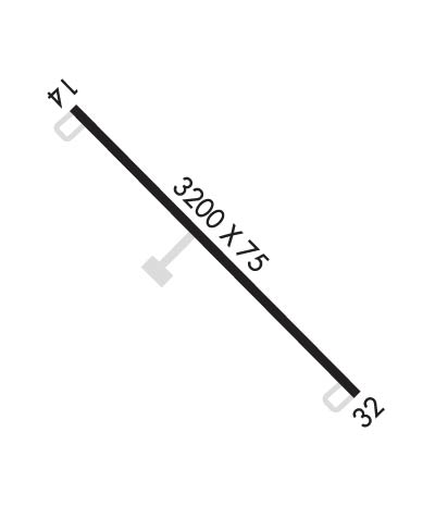
Runway Identifications
Runway Identification: 14/32
Length: 3200 ft
Width: 75 ft
Surface: ASPHALT
Edge lights: Medium Intensity

Treatment: NONE

 Runway: 14   Runway: 32
Mag heading: N/AMag heading: N/A
Approach: Approach:
Pattern: Left TrafficPattern: Left Traffic
Markings: BASICMarkings: BASIC
Marking Condition: GOODMarking Condition: GOOD
Arresting Dev: Arresting Dev:
Lat & Long: N3217.2  W08430.4Lat. & Long.: N3216.8  W08430.0
Elev: N/AElev: N/A
TCH: TCH:
Visual Glide Path: Visual Glide Path:
Displaced Threshold: NoDisplaced Threshold: No
Touchdown Zone: NOTouchdown Zone: NO
Touchdown Elev.: Touchdown Elev.:
Visual Glide Slope: Visual Glide Slope:
RVR Equipment: RVR Equipment:
RVV Equipment: NORVV Equipment: NO
Approach Lights: Approach Lights:
REIL: NOREIL: NO
Centerline Lights: NOCenterline Lights: NO
Touchdown lights: NOTouchdown lights: NO
Runway Category: Runway with a Visual ApproachRunway Category: Runway with a Visual Approach
Declared Distances: Declared Distances:
Obstructions: TREESObstructions: TREES
Marked: NOT Marked/LightedMarked: NOT Marked/Lighted
Clearance slope: 25:1Clearance slope: 34:1
Obstruction height: 34 feet AGLObstruction height: 38 feet AGL
Dist. from runway: 1050 feetDist. from runway: 1492 feet
Centerline offset: 200 left of centerlineCenterline offset: 210 feet right of centerline
Comments: Comments:
C:/P: