Approach Charts
| FltPlan does not have IFR approach charts available for K7Y2. |
Current Weather/Notams (Metars, TAFs, Notams, NWS Forecast, PIREPS, and nearby weather)
Customs Information Send updates to Support@FltPlan.com
Customs Not Available
Database effective 05/16/2024
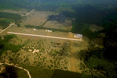
| Facility Name: | THOMPSONVILLE |
| City Name: | THOMPSONVILLE |
| County: | BENZIE |
| State abbrev: | MI |
| State Name: | MICHIGAN |
| | |
| Ownership: | PUBLICLY OWNED |
| Use: | OPEN TO THE PUBLIC |
| Owner's Name: | VILLAGE OF THOMPSONVILLE |
| Address: | 14714 LINCOLN AVE |
| | THOMPSONVILLE, MI 49683-9109 |
| Owner's Phone: | 231-378-2575 |
| | |
| Manager's Name: | MARV PREPEJCHAL |
| Address: | 20266 VALENCOURT RD |
| | COPEMISH, MI 49625-9735 |
| Phone: | 231-649-3802; CELL. RES 231-378-2435. |
| | |
| FAA Region: | GREAT LAKES |
| FAA Field Office: | DET |
Runway Identifications
Runway Identification: 09/27Length: 2900 ft
Width: 75 ft
Surface: ASPHALT-GOOD CONDITION
Edge lights: Low IntensityTreatment: NONE
| | Runway: 09 | | Runway: 27 |
| Mag heading: | N/A | Mag heading: | N/A |
| Rwy Slope: | .00% | Rwy Slope: | .00% |
| Approach: | | Approach: | |
| Pattern: | Right Traffic | Pattern: | Left Traffic |
| Markings: | BASIC | Markings: | BASIC |
| Marking Condition: | FAIR | Marking Condition: | FAIR |
| Arresting Dev: | | Arresting Dev: | |
| Lat & Long: | N4431.1 W08558.7 | Lat. & Long.: | N4431.1 W08558.0 |
| Elev: | 793.0 ft. MSL | Elev: | 793.0 ft. MSL |
| TCH: | | TCH: | 20 ft. AGL |
| Visual Glide Path: | | Visual Glide Path: | 4.00 degrees |
| Displaced Threshold: | 60 feet | Displaced Threshold: | No |
| Touchdown Zone: | NO | Touchdown Zone: | NO |
| Touchdown Elev.: | | Touchdown Elev.: | |
| Visual Glide Slope: | | Visual Glide Slope: | 2-Light PAPI on LEFT side of Runway |
| RVR Equipment: | | RVR Equipment: | |
| RVV Equipment: | NO | RVV Equipment: | NO |
| Approach Lights: | | Approach Lights: | |
| REIL: | NO | REIL: | NO |
| Centerline Lights: | NO | Centerline Lights: | NO |
| Touchdown lights: | NO | Touchdown lights: | NO |
| Runway Category: | Runway with a Visual Approach | Runway Category: | Runway with a Visual Approach |
| Declared Distances: | | Declared Distances: | |
| Obstructions: | ROAD | Obstructions: | TREE |
| Marked: | NOT Marked/Lighted | Marked: | NOT Marked/Lighted |
| Clearance slope: | 2:1 | Clearance slope: | 3:1 |
| Obstruction height: | 14 feet AGL | Obstruction height: | 14 feet AGL |
| Dist. from runway: | 240 feet | Dist. from runway: | 250 feet |
| Centerline offset: | | Centerline offset: | 125 feet right of centerline |
| Comments: | + 4 FT FENCE, 185 FT DSTC L/R. | Comments: | |
Runway Identification: 17/35Length: 2475 ft
Width: 150 ft
Surface: GRASS-FAIR CONDITION
Edge lights: Treatment: NONE
| | Runway: 17 | | Runway: 35 |
| Mag heading: | N/A | Mag heading: | N/A |
| Rwy Slope: | .00% | Rwy Slope: | .00% |
| Approach: | | Approach: | |
| Pattern: | Left Traffic | Pattern: | Right Traffic |
| Markings: | | Markings: | |
| Marking Condition: | RWY & DTHR MKD WITH 3 FT YELLOW CONES. | Marking Condition: | RWY & DTHR MKD WITH 3 FT YELLOW CONES. |
| Arresting Dev: | | Arresting Dev: | |
| Lat & Long: | N4431.2 W08558.1 | Lat. & Long.: | N4430.8 W08558.0 |
| Elev: | 793.0 ft. MSL | Elev: | 793.0 ft. MSL |
| TCH: | | TCH: | |
| Visual Glide Path: | | Visual Glide Path: | |
| Displaced Threshold: | 1212 feet | Displaced Threshold: | 1085 feet |
| Touchdown Zone: | NO | Touchdown Zone: | NO |
| Touchdown Elev.: | | Touchdown Elev.: | |
| Visual Glide Slope: | | Visual Glide Slope: | |
| RVR Equipment: | | RVR Equipment: | |
| RVV Equipment: | NO | RVV Equipment: | NO |
| Approach Lights: | | Approach Lights: | |
| REIL: | NO | REIL: | NO |
| Centerline Lights: | NO | Centerline Lights: | NO |
| Touchdown lights: | NO | Touchdown lights: | NO |
| Runway Category: | Runway with a Visual Approach | Runway Category: | Runway with a Visual Approach |
| Declared Distances: | | Declared Distances: | |
| Obstructions: | TREES | Obstructions: | TREES |
| Marked: | NOT Marked/Lighted | Marked: | NOT Marked/Lighted |
| Clearance slope: | APCH RATIO 15:1 TO DTHR. | Clearance slope: | APCH RATIO 15:1 TO DTHR. |
| Obstruction height: | 70 feet AGL | Obstruction height: | 75 feet AGL |
| Dist. from runway: | 50 feet | Dist. from runway: | 40 feet |
| Centerline offset: | 75 right of centerline | Centerline offset: | |
| Comments: | | Comments: | |