Click here for more info on on SMS!

K7W4

LAKE ANNA
BUMPASS
VA
Time Zone: Eastern
Lat: N 3757.9
Long: W 07744.8
Elev: 351
Var: +10
Longest Runway: 2558
AWOS: 120.77
CTAF: 122.9

FBO & Flight Services info for K7W4

FBOs: Update your Fuel Prices

AIRPORT (UNATTD)
-
Freq: 122.9
Service
Jet
100LL
SAF
MoGas
Fuel Avail: NO FUEL AVAILABLE
Full        Last Update: 04/24/2024 06:02:17

Self        
AWOSPh: 540-872-0303
-
Freq: 120.77  
If you are an FBO, call 1-203-262-1700 to update your info or email: FltPlan.Advertising@garmin.com
Advertise your FBO on FltPlan.com

Runway & Approach Info for K7W4
Rwy
Length
Land Dist**
Approach*
  Rwy
Length
Land Dist**
Approach*
08
2558x50  2558'          
 
  
26
  2558x50  2558'          
 
 * only ILS, LOC, LDA, and SDF approaches to a specific runway are shown
** For any Declared Landing Distance Available, please see A/FD or Approach plates
Runway Weight Capability (lbs.) Help
Runway IDSingle WheelDouble WheelDouble Tandem WheelDual Double Wheel
08/266,000N/AN/AN/A
These numbers are Advisory and are not limits.   The Airport Manager should have more accurate Weight Limits
Approach Charts
Approaches    
Current Weather/Notams
Customs Information Send updates to Support@FltPlan.com
Customs Not Available
Database effective 05/16/2024
Airport Diagram of K7W4
Airport Diagram might not be current.

Facility Name: LAKE ANNA
City Name: BUMPASS
County: LOUISA
State abbrev: VA
State Name: VIRGINIA
   
Ownership: PRIVATELY OWNED
Use: OPEN TO THE PUBLIC
Owner's Name: MILE HIGH CHARTERS, LLC
Address: 10267 MATTHEWS GROVE LN.
 MECHANICSVILLE, VA 23116
Owner's Phone: 804-550-5794
  
Manager's Name: RICHARD HENRY REMPE
Address: 10267 MATTHEWS GROVE LN.
 MECHANICSVILLE, VA 23116
Phone: 804-550-5794; EMERGENCY PHONE NUMBER IS: (804) 514-6642
   
FAA Region: EASTERN
FAA Field Office: DCA


Sunrise / Sunset times for LAKE ANNA

DateSunriseSunset
04/23/24 Tuesday6:2419:55
04/24/24 Wednesday6:2319:56
04/25/24 Thursday6:2119:57
04/26/24 Friday6:2019:58
04/27/24 Saturday6:1919:59
04/28/24 Sunday6:1820:00
04/29/24 Monday6:1620:01
04/30/24 Tuesday6:1520:02
05/01/24 Wednesday6:1420:02
05/02/24 Thursday6:1320:03
05/03/24 Friday6:1220:04
05/04/24 Saturday6:1120:05
05/05/24 Sunday6:1020:06
05/06/24 Monday6:0920:07

Airport Facilities

Airport Attendance ScheduleUNATTENDED
Airport Status OPERATIONAL (This Status can change at any time - please check NOTAMS)
Airport Lighting ScheduleACTVT MIRL RY 08/26 - CTAF
Airport Storage AvailableTie Downs
Extra Services AvailableNONE
Wind IndicatorNONE
Control TowerNO
CTAF Frequency122.900
Unicom FrequencyCTAF 122.90
Rotating Beacon ColorWG
Segmented CircleNO
Landing FeeNO

Airport Inspection Data

Airport InspectedSTATE - performed by STATE AERONAUTICAL PERSONNEL
Inspection Date03/30/2023

Airport Services

Type of Fuel AvailableNone
Airframe Repair ServiceNONE
Power Plant Repair ServiceNONE

Geographic Data

LatitudeN3757.9
LongitudeW07744.8 (ESTIMATED)
Arpt Elevation351ft (ESTIMATED)
Magnetic Variation10W
0 miles NWof BUMPASS
Traffic Pattern Altitude
Sectional ChartWASHINGTON

Aircraft Data

Operations (Reported)YearlyAvg. Daily
General Aviation Transient 1750
General Aviation Local 7502
Air Taxi 00
Commerical 00
Commuter 00
Military 450
Aircraft based on Field
General Aviation Singles 2
General Aviation Multi 1
Jet Aircraft 0
General Aviation Helicopters 0
Military Aircraft 0
Gliders 0
Ultralights 0

FAA Services

FSS on field NO
FSS tie-in LEESBURG
FSS Phone 1-800-WX-BRIEF
Who issues Notams DCA
Notam D service at airport YES
ARTCC Name WASHINGTON

Federal Status

Airport Certification
Aircraft Rescue & Firefighting IndexNone
Airport of EntryNo
Custom Landing RightsNo
Joint Civil/MilitaryNo
Military Landing rightsNo

Remarks

DEER ON & INVOF ARPT.
FOR CD CTC POTOMAC APCH AT 866-640-4124.
Airport Communications & Frequencies:
CTAF Frequency:
122.900
Unicom Frequency:
CTAF 122.90
Remarks
  • APCH/DEP SVC PRVDD BY POTOMAC TRACON 126.75/307.2 .
  • POTOMAC Primary Approach Frequencies:  
    126.75
    307.2
    POTOMAC Primary Departure Frequencies:  
    126.75
    307.2
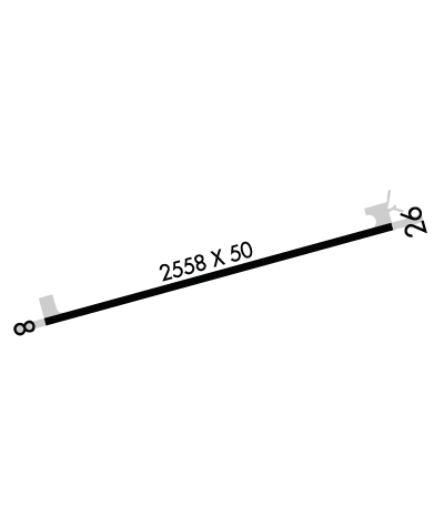
    Runway Identifications
    Runway Identification: 08/26
    Length: 2558 ft
    Width: 50 ft
    Surface: ASPHALT-GOOD CONDITION
    Edge lights: Medium Intensity

    Treatment: NONE

     Runway: 08   Runway: 26
    Mag heading: 85°Mag heading: 265°
    Rwy Slope: .07% UpRwy Slope: -.07% Down
    Approach: Approach:
    Pattern: Left TrafficPattern: Left Traffic
    Markings: NONPRECISION INSTRUMENTMarkings: NONPRECISION INSTRUMENT
    Marking Condition: GOODMarking Condition: GOOD
    Arresting Dev: Arresting Dev:
    Lat & Long: N3757.9  W07745.0Lat. & Long.: N3758.0  W07744.5
    Elev: 349.5 ft. MSLElev: 351.2 ft. MSL
    TCH: TCH:
    Visual Glide Path: Visual Glide Path:
    Displaced Threshold: NoDisplaced Threshold: No
    Touchdown Zone: YESTouchdown Zone: YES
    Touchdown Elev.: 351.2 feetTouchdown Elev.: 351.2 feet
    Visual Glide Slope: Visual Glide Slope:
    RVR Equipment: RVR Equipment:
    RVV Equipment: NORVV Equipment: NO
    Approach Lights: Approach Lights:
    REIL: NOREIL: NO
    Centerline Lights: NOCenterline Lights: NO
    Touchdown lights: NOTouchdown lights: NO
    Runway Category: Runway with a Non-precision ApproachRunway Category: Runway with a Non-precision Approach
    Declared Distances: Declared Distances:
    Obstructions: TREESObstructions: TREE
    Marked: NOT Marked/LightedMarked: NOT Marked/Lighted
    Clearance slope: 12:1Clearance slope: 13:1
    Obstruction height: 63 feet AGLObstruction height: 59 feet AGL
    Dist. from runway: 1011 feetDist. from runway: 1022 feet
    Centerline offset: 13 left of centerlineCenterline offset: 116 feet left of centerline
    Comments: Comments:
    C:/P: