Approach Charts
FltPlan does not have IFR approach charts available for K7S3.
Current Weather/Notams (Metars, TAFs, Notams, NWS Forecast, PIREPS, and nearby weather)
Customs Information Send updates to Support@FltPlan.com
Customs Not Available
Database effective 05/16/2024
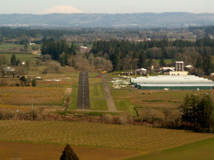
Facility Name: STARK'S TWIN OAKS AIRPARK City Name: HILLSBORO County: WASHINGTON State abbrev: OR State Name: OREGON Ownership: PRIVATELY OWNED Use: OPEN TO THE PUBLIC Owner's Name: ROBERT C & BETTY STARK Address: 12405 S.W. RIVER RD HILLSBORO, OR 97123 Owner's Phone: 503-522-8952 Manager's Name: ROBERT C. STARK; BOB@TWINOAKSAIRPARK.COM Address: 12405 S.W. RIVER RD HILLSBORO, OR 97123 Phone: 503-628-2817 FAA Region: NORTHWEST MOUNTAIN FAA Field Office: SEA
Runway Identifications Help
Runway Identification: 02/20 Length: 2465 ftWidth: 48 ftSurface: ASPHALT-GOOD CONDITIONEdge lights: Low Intensity Treatment: NONE Runway: 02 Runway: 20 Mag heading: N/A Mag heading: N/A Approach: Approach: Pattern: Left Traffic Pattern: Left Traffic Markings: NONSTANDARD Markings: NONSTANDARD Marking Condition: GOOD Marking Condition: GOOD Arresting Dev: Arresting Dev: Lat & Long: Lat. & Long.: Elev: N/A Elev: N/A TCH: TCH: Visual Glide Path: Visual Glide Path: Displaced Threshold: 100 feet Displaced Threshold: No Touchdown Zone: NO Touchdown Zone: NO Touchdown Elev.: Touchdown Elev.: Visual Glide Slope: Visual Glide Slope: RVR Equipment: RVR Equipment: RVV Equipment: NO RVV Equipment: NO Approach Lights: Approach Lights: REIL: NO REIL: NO Centerline Lights: NO Centerline Lights: NO Touchdown lights: NO Touchdown lights: NO Runway Category: Runway with a Visual Approach Runway Category: Runway with a Visual Approach Declared Distances: Declared Distances: Obstructions: Obstructions: TREES Marked: Marked: NOT Marked/Lighted Clearance slope: 20:1 Clearance slope: Obstruction height: Obstruction height: 15 feet AGL Dist. from runway: Dist. from runway: 210 feet Centerline offset: Centerline offset: 30 feet right of centerline Comments: Comments: 20 FT TREES AT 175 FT AND 120 FT LEFT OF CNTRLN. NO SAFETY AREA. ALSO, 10 FT PUB ROAD AT 180 FT XNG CNTRLN.