Approach Charts
| FltPlan does not have IFR approach charts available for K7M9. |
Current Weather/Notams (Metars, TAFs, Notams, NWS Forecast, PIREPS, and nearby weather)
Customs Information Send updates to Support@FltPlan.com
Customs Not Available
Database effective 05/16/2024
Airport Diagram might not be current.
|
| Facility Name: | SALEM |
| City Name: | SALEM |
| County: | FULTON |
| State abbrev: | AR |
| State Name: | ARKANSAS |
| | |
| Ownership: | PUBLICLY OWNED |
| Use: | OPEN TO THE PUBLIC |
| Owner's Name: | CITY OF SALEM |
| Address: | PO BOX 619 |
| | SALEM, AR 72576 |
| Owner's Phone: | 870-895-3478 |
| | |
| Manager's Name: | ELBERT LAYNE |
| Address: | PO BOX 1015 |
| | SALEM, AR 72576 |
| Phone: | (870) 371-0756 |
| | |
| FAA Region: | SOUTHWEST |
| FAA Field Office: | AOK |
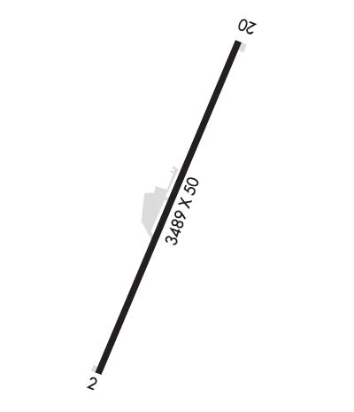
Runway Identifications
Runway Identification: 02/20Length: 3489 ft
Width: 50 ft
Surface: ASPHALT-GOOD CONDITION
Edge lights: Medium IntensityTreatment: NONE
| | Runway: 02 | | Runway: 20 |
| Mag heading: | 20° | Mag heading: | 200° |
| Rwy Slope: | -2.37% Down | Rwy Slope: | 2.37% Up |
| Approach: | | Approach: | |
| Pattern: | Left Traffic | Pattern: | Left Traffic |
| Markings: | BASIC | Markings: | NONPRECISION INSTRUMENT |
| Marking Condition: | GOOD | Marking Condition: | GOOD |
| Arresting Dev: | | Arresting Dev: | |
| Lat & Long: | N3621.1 W09150.0 | Lat. & Long.: | N3621.6 W09149.7 |
| Elev: | 786.7 ft. MSL | Elev: | 704.0 ft. MSL |
| TCH: | | TCH: | |
| Visual Glide Path: | | Visual Glide Path: | |
| Displaced Threshold: | 1233 feet | Displaced Threshold: | 248 feet |
| Touchdown Zone: | YES | Touchdown Zone: | YES |
| Touchdown Elev.: | 786.7 feet | Touchdown Elev.: | 760.2 feet |
| Visual Glide Slope: | | Visual Glide Slope: | |
| RVR Equipment: | | RVR Equipment: | |
| RVV Equipment: | NO | RVV Equipment: | NO |
| Approach Lights: | | Approach Lights: | |
| REIL: | NO | REIL: | NO |
| Centerline Lights: | NO | Centerline Lights: | NO |
| Touchdown lights: | NO | Touchdown lights: | NO |
| Runway Category: | Runway with a Visual Approach | Runway Category: | Runway with a Visual Approach |
| Declared Distances: | | Declared Distances: | |
| Obstructions: | HILL | Obstructions: | TREE |
| Marked: | LIGHTED; OBSTN LIGHT OTS INDEFLY. | Marked: | NOT Marked/Lighted |
| Clearance slope: | APCH SLOPE 14:1 TO DSPLCD THLD. | Clearance slope: | 12:1; APCH SLOPE 37:1 TO DSPLCD THLD. |
| Obstruction height: | 50 feet AGL | Obstruction height: | 25 feet AGL |
| Dist. from runway: | 200 feet | Dist. from runway: | 500 feet |
| Centerline offset: | 150 right of centerline | Centerline offset: | 75 feet left of centerline |
| Comments: | +50 FT HILL 20 FT FM THLD BOTH SIDES OF CNTRLN. | Comments: | +60 FT TREES 50 FT L OF CNTRLN 100 FT FM RY END; +10 FT ROAD 50 FT FM RY END. |

