Approach Charts
| FltPlan does not have IFR approach charts available for K7M3. |
Current Weather/Notams (Metars, TAFs, Notams, NWS Forecast, PIREPS, and nearby weather)
Customs Information Send updates to Support@FltPlan.com
Customs Not Available
Database effective 04/18/2024
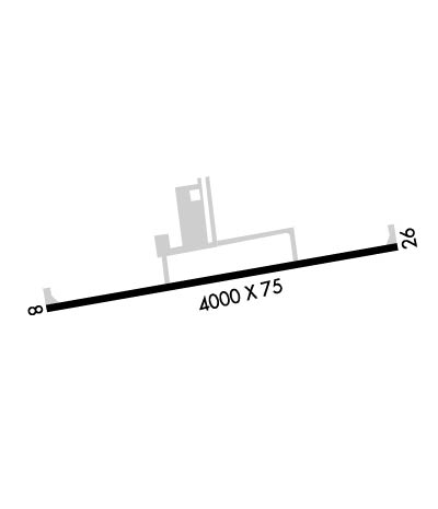
Airport Diagram might not be current.
|
| Facility Name: | BEARCE |
| City Name: | MOUNT IDA |
| County: | MONTGOMERY |
| State abbrev: | AR |
| State Name: | ARKANSAS |
| | |
| Ownership: | PUBLICLY OWNED |
| Use: | OPEN TO THE PUBLIC |
| Owner's Name: | CITY OF MOUNT IDA |
| Address: | CITY HALL |
| | MOUNT IDA, AR 71957 |
| Owner's Phone: | 870-867-3541 |
| | |
| Manager's Name: | LEON TURNAGE |
| Address: | P.O. BOX 631 |
| | WEATHERFORD, TX 76086 |
| Phone: | 817-999-3310; 100LL/JET A AVBL 24/7 CALL 817-999-4479 OR 817-999-3310 FOR SERV |
| | |
| FAA Region: | SOUTHWEST |
| FAA Field Office: | AOK |
Runway Identifications
Runway Identification: 08/26Length: 4000 ft
Width: 75 ft
Surface: ASPHALT-FAIR CONDITION
Edge lights: Medium IntensityTreatment: NONE
| | Runway: 08 | | Runway: 26 |
| Mag heading: | 75° | Mag heading: | 255° |
| Rwy Slope: | -.37% Down | Rwy Slope: | .37% Up |
| Approach: | | Approach: | |
| Pattern: | Left Traffic | Pattern: | Right Traffic |
| Markings: | NONPRECISION INSTRUMENT | Markings: | NONPRECISION INSTRUMENT |
| Marking Condition: | POOR; MKGS RWY 8 FADED. | Marking Condition: | POOR; MKGS RWY 26 FADED. |
| Arresting Dev: | | Arresting Dev: | |
| Lat & Long: | N3431.7 W09332.2 | Lat. & Long.: | N3431.8 W09331.4 |
| Elev: | 644.4 ft. MSL | Elev: | 629.6 ft. MSL |
| TCH: | 70 ft. AGL | TCH: | 72 ft. AGL |
| Visual Glide Path: | 4.00 degrees | Visual Glide Path: | 4.00 degrees |
| Displaced Threshold: | No | Displaced Threshold: | 180 feet |
| Touchdown Zone: | YES | Touchdown Zone: | YES |
| Touchdown Elev.: | 644.4 feet | Touchdown Elev.: | 643.0 feet |
| Visual Glide Slope: | 2-Light PAPI on RIGHT side of Runway; PAPI UNUSBL BYD 8 DEGS LEFT AND BYD 5 DEGS RIGHT OF CNTRLN. | Visual Glide Slope: | 2-Light PAPI on RIGHT side of Runway; PAPI UNUSBL BYD 8 DEGS RIGHT OF CNTRLN. |
| RVR Equipment: | | RVR Equipment: | |
| RVV Equipment: | NO | RVV Equipment: | NO |
| Approach Lights: | | Approach Lights: | |
| REIL: | NO | REIL: | NO |
| Centerline Lights: | NO | Centerline Lights: | NO |
| Touchdown lights: | NO | Touchdown lights: | NO |
| Runway Category: | Runway with a Visual Approach | Runway Category: | Runway with a Visual Approach |
| Declared Distances: | | Declared Distances: | |
| Obstructions: | TREE | Obstructions: | TREES |
| Marked: | NOT Marked/Lighted | Marked: | NOT Marked/Lighted |
| Clearance slope: | 15:1 | Clearance slope: | 7:1; APCH SLOPE 17:1 TO DSPLCD THLD. |
| Obstruction height: | 70 feet AGL | Obstruction height: | 38 feet AGL |
| Dist. from runway: | 1300 feet | Dist. from runway: | 470 feet |
| Centerline offset: | 135 left of centerline | Centerline offset: | 55 feet left of centerline |
| Comments: | | Comments: | |

