Current Weather/Notams (Metars, TAFs, Notams, NWS Forecast, PIREPS, and nearby weather)
Customs Information Send updates to Support@FltPlan.com
Customs Not Available
Database effective 04/18/2024
Airport Diagram might not be current.
|
| Facility Name: | MOUNTAIN VIEW WILCOX MEML FLD |
| City Name: | MOUNTAIN VIEW |
| County: | STONE |
| State abbrev: | AR |
| State Name: | ARKANSAS |
| | |
| Ownership: | PUBLICLY OWNED |
| Use: | OPEN TO THE PUBLIC |
| Owner's Name: | CITY OF MOUNTAIN VIEW |
| Address: | CITY HALL |
| | MOUNTAIN VIEW, AR 72560 |
| Owner's Phone: | 870-269-3804 |
| | |
| Manager's Name: | LARRY SNYDER |
| Address: | 1501 AIRPORT LANE |
| | MOUNTAIN VIEW, AR 72560 |
| Phone: | 501-203-8644 |
| | |
| FAA Region: | SOUTHWEST |
| FAA Field Office: | AOK |
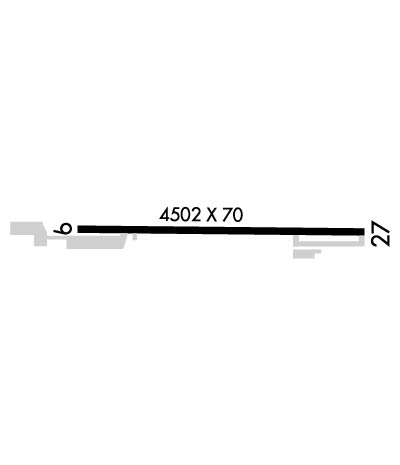
Runway Identifications
Runway Identification: 09/27Length: 4502 ft
Width: 70 ft
Surface: ASPHALT-FAIR CONDITION
Edge lights: Medium IntensityTreatment: NONE
| | Runway: 09 | | Runway: 27 |
| Mag heading: | 92° | Mag heading: | 272° |
| Rwy Slope: | -.53% Down | Rwy Slope: | .53% Up |
| Approach: | | Approach: | |
| Pattern: | Left Traffic | Pattern: | Left Traffic |
| Markings: | NONPRECISION INSTRUMENT | Markings: | NONPRECISION INSTRUMENT |
| Marking Condition: | FAIR | Marking Condition: | FAIR |
| Arresting Dev: | | Arresting Dev: | |
| Lat & Long: | N3551.9 W09205.9 | Lat. & Long.: | N3551.9 W09205.0 |
| Elev: | 804.0 ft. MSL | Elev: | 780.0 ft. MSL |
| TCH: | | TCH: | |
| Visual Glide Path: | | Visual Glide Path: | |
| Displaced Threshold: | No | Displaced Threshold: | No |
| Touchdown Zone: | YES | Touchdown Zone: | YES |
| Touchdown Elev.: | 805.0 feet | Touchdown Elev.: | 796.0 feet |
| Visual Glide Slope: | | Visual Glide Slope: | |
| RVR Equipment: | | RVR Equipment: | |
| RVV Equipment: | NO | RVV Equipment: | NO |
| Approach Lights: | | Approach Lights: | |
| REIL: | NO | REIL: | NO |
| Centerline Lights: | NO | Centerline Lights: | NO |
| Touchdown lights: | NO | Touchdown lights: | NO |
| Runway Category: | Runway with a Visual Approach | Runway Category: | Runway with a Visual Approach |
| Declared Distances: | | Declared Distances: | |
| Obstructions: | BLDG | Obstructions: | TOWER |
| Marked: | NOT Marked/Lighted | Marked: | LIGHTED |
| Clearance slope: | 11:1 | Clearance slope: | 14:1 |
| Obstruction height: | 21 feet AGL | Obstruction height: | 355 feet AGL |
| Dist. from runway: | 435 feet | Dist. from runway: | 5280 feet |
| Centerline offset: | 110 right of centerline | Centerline offset: | |
| Comments: | | Comments: | 6-8 FT BRUSH APRX 50 FT FM RWY END. |

