Click here for more info on on SMS!

K7G8

GEAUGA COUNTY
MIDDLEFIELD
OH
Time Zone: Eastern
Lat: N 4127.0
Long: W 08103.8
Elev: 1174
Var: +09
Longest Runway: 3500
CTAF: 123.0

FBO & Flight Services info for K7G8

FBOs: Update your Fuel Prices

GEAUGA COUNTYPh: 440-632-1884
-
Freq: 123.0
Service
Jet
100LL
SAF
MoGas
Fuel Avail: ~~ CALL AHEAD FOR FUEL, NEED CARD KEY, ARPT OPENED LIMITED HOURS.
Full        Last Update: 04/19/2024 00:01:44

Self        
 Address: GEAUGA COUNTY ARPT   MIDDLEFIELD, OH 44024
If you are an FBO, call 1-203-262-1700 to update your info or email: FltPlan.Advertising@garmin.com
Advertise your FBO on FltPlan.com

Runway & Approach Info for K7G8
Rwy
Length
Land Dist**
Approach*
  Rwy
Length
Land Dist**
Approach*
11
3500x65  3321'          
 
  
29
  3500x65  3500'          
 
 * only ILS, LOC, LDA, and SDF approaches to a specific runway are shown
** For any Declared Landing Distance Available, please see A/FD or Approach plates
Runway Weight Capability (lbs.) Help
Runway IDSingle WheelDouble WheelDouble Tandem WheelDual Double Wheel
11/2918,500N/AN/AN/A
These numbers are Advisory and are not limits.   The Airport Manager should have more accurate Weight Limits
Approach Charts
Approaches    
Current Weather/Notams
Customs Information Send updates to Support@FltPlan.com
Customs Not Available
Database effective 04/18/2024
Airport Diagram of K7G8
Airport Diagram might not be current.

Facility Name: GEAUGA COUNTY
City Name: MIDDLEFIELD
County: GEAUGA
State abbrev: OH
State Name: OHIO
   
Ownership: PUBLICLY OWNED
Use: OPEN TO THE PUBLIC
Owner's Name: GEAUGA CO BOARD OF COMM
Address: COURTHOUSE ANNEX, 231 MAIN ST
 CHARDON, OH 44024-1263
Owner's Phone: 440-285-2222
  
Manager's Name: RICHARD BLAMER; 7G8MANAGER@GMAIL.COM.
Address: PO BOX 1308
 MIDDLEFIELD, OH 44062-1308
Phone: 440-632-1884; CELL 216-509-8858.
   
FAA Region: GREAT LAKES
FAA Field Office: DET


Sunrise / Sunset times for GEAUGA COUNTY

DateSunriseSunset
04/18/24 Thursday6:3920:09
04/19/24 Friday6:3720:10
04/20/24 Saturday6:3620:11
04/21/24 Sunday6:3420:12
04/22/24 Monday6:3320:13
04/23/24 Tuesday6:3120:14
04/24/24 Wednesday6:3020:15
04/25/24 Thursday6:2920:16
04/26/24 Friday6:2720:17
04/27/24 Saturday6:2620:18
04/28/24 Sunday6:2420:20
04/29/24 Monday6:2320:21
04/30/24 Tuesday6:2220:22
05/01/24 Wednesday6:2020:23

Airport Facilities

Airport Attendance ScheduleMON-FRI 0900-1700 IREG
Airport Status OPERATIONAL (This Status can change at any time - please check NOTAMS)
Airport Lighting ScheduleACTVT REIL RWY 11 & 29; PAPI RWY 29; MIRL RWY 11/29 - CTAF.
Airport Storage AvailableTie Downs, Hanger
Extra Services AvailableAir Ambulance, Glider, Glider Towing
Wind IndicatorYES - (lighted)
Control TowerNO
CTAF Frequency123.000
Unicom Frequency123.000
Rotating Beacon ColorWG
Segmented CircleNO
Landing FeeNO

Airport Inspection Data

Airport InspectedSTATE - performed by STATE AERONAUTICAL PERSONNEL
Inspection Date06/29/2023

Airport Services

Type of Fuel AvailableGrade 100LLMOGAS; -10100LL AVBL H24 VIA CREDIT CARD.
Airframe Repair ServiceNONE
Power Plant Repair ServiceNONE

Geographic Data

LatitudeN4127.0
LongitudeW08103.8 (ESTIMATED)
Arpt Elevation1174ft (SURVEYED)
Magnetic Variation09W
1 miles SEof MIDDLEFIELD
Traffic Pattern Altitude1025
Sectional ChartDETROIT

Aircraft Data

Operations (Reported)YearlyAvg. Daily
General Aviation Transient 15004
General Aviation Local 1800049
Air Taxi 8002
Commerical 00
Commuter 00
Military 5001
Aircraft based on Field
General Aviation Singles 40
General Aviation Multi 2
Jet Aircraft 0
General Aviation Helicopters 1
Military Aircraft 0
Gliders 5
Ultralights 0

FAA Services

FSS on field NO
FSS tie-in CLEVELAND
FSS Phone 1-800-WX-BRIEF
Who issues Notams CLE
Notam D service at airport YES
ARTCC Name CLEVELAND

Federal Status

Airport Certification
Aircraft Rescue & Firefighting IndexNone
Airport of EntryNo
Custom Landing RightsNo
Joint Civil/MilitaryNo
Military Landing rightsNo

Federal Agreements

NATIONAL PLAN OF INTEGRATED AIRPORT SYSTEMS (NPIAS)

Remarks

PARL TWY EAST OF TEE HNGRS CLSD PERMLY.
EXTSV GLDR ACT ON & INVOF ARPT.
DEER, BIRDS, & OTR WILDLIFE ON & INVOF ARPT.
FOR CD CTC CLEVELAND APCH AT 216-352-2323.
ADZY ONLY WX AVBL - 4 CLICKS CTAF.
Airport Communications & Frequencies:
CTAF Frequency:
123.000
Unicom Frequency:
123.000
CLEVELAND Primary Approach Frequencies:  
125.35
346.325
CLEVELAND Primary Departure Frequencies:  
125.35
346.325
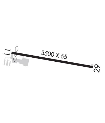
Runway Identifications
Runway Identification: 11/29
Length: 3500 ft
Width: 65 ft
Surface: ASPHALT-GOOD CONDITION
Edge lights: Medium Intensity

Treatment: NONE

 Runway: 11   Runway: 29
Mag heading: 109°Mag heading: 289°
Rwy Slope: -.47% DownRwy Slope: .47% Up
Approach: Approach:
Pattern: Left TrafficPattern: Left Traffic
Markings: NONPRECISION INSTRUMENTMarkings: NONPRECISION INSTRUMENT
Marking Condition: GOODMarking Condition: GOOD
Arresting Dev: Arresting Dev:
Lat & Long: N4127.0  W08104.2Lat. & Long.: N4126.9  W08103.4
Elev: 1174.3 ft. MSLElev: 1157.9 ft. MSL
TCH: TCH: 23 ft. AGL
Visual Glide Path: Visual Glide Path: 3.00 degrees
Displaced Threshold: 179 feetDisplaced Threshold: No
Touchdown Zone: YESTouchdown Zone: YES
Touchdown Elev.: 1172.0 feetTouchdown Elev.: 1167.1 feet
Visual Glide Slope: Visual Glide Slope: 2-Light PAPI on LEFT side of Runway
RVR Equipment: RVR Equipment:
RVV Equipment: NORVV Equipment: NO
Approach Lights: Approach Lights:
REIL: YESREIL: YES
Centerline Lights: NOCenterline Lights: NO
Touchdown lights: NOTouchdown lights: NO
Runway Category: Runway with a Non-precision ApproachRunway Category: Runway with a Non-precision Approach
Declared Distances: Declared Distances:
Obstructions: ANTObstructions:
Marked: LIGHTEDMarked:
Clearance slope: 7:1; APCH RATIO 16:1 TO DTHR.Clearance slope: 20:1
Obstruction height: 45 feet AGLObstruction height:
Dist. from runway: 551 feetDist. from runway:
Centerline offset: 160 right of centerlineCenterline offset:
Comments: +3-6 FT BRUSH, 0-140 FT DIST, 220 FT L.Comments:
C:1/P: