Click here for more info on on SMS!

K7G0

LEDGEDALE AIRPARK
BROCKPORT
NY
Time Zone: Eastern
Lat: N 4310.9
Long: W 07754.9
Elev: 665
Var: +11
Longest Runway: 4206
CTAF: 122.7

FBO & Flight Services info for K7G0

FBOs: Update your Fuel Prices

LEDGEDALE AIRPARKPh: 585-637-5050
-
Freq: 122.7
Service
Jet
100LL
SAF
MoGas
Fuel Avail: PRIST Premixed. Please call in advance for full serviced.
Full        Caution: Fuel prices have not been updated in 31 days.
Last Update: 03/24/2024 10:21

Self5.696.49    
 Address: 21 EISENHAUER DR,   BROCKPORT, NY 14420
If you are an FBO, call 1-203-262-1700 to update your info or email: FltPlan.Advertising@garmin.com
Advertise your FBO on FltPlan.com

Runway & Approach Info for K7G0
Rwy
Length
Land Dist**
Approach*
  Rwy
Length
Land Dist**
Approach*
10
4206x75  4206'          
 
  
28
  4206x75  4206'          
 
 * only ILS, LOC, LDA, and SDF approaches to a specific runway are shown
** For any Declared Landing Distance Available, please see A/FD or Approach plates
Runway Weight Capability (lbs.) Help
Runway IDSingle WheelDouble WheelDouble Tandem WheelDual Double Wheel
10/2812,000N/AN/AN/A
These numbers are Advisory and are not limits.   The Airport Manager should have more accurate Weight Limits
Approach Charts
Approaches    
Current Weather/Notams
Customs Information Send updates to Support@FltPlan.com
Customs Not Available
Database effective 05/16/2024
Airport Diagram of K7G0
Airport Diagram might not be current.

Facility Name: LEDGEDALE AIRPARK
City Name: BROCKPORT
County: MONROE
State abbrev: NY
State Name: NEW YORK
   
Ownership: PRIVATELY OWNED
Use: OPEN TO THE PUBLIC
Owner's Name: BIG FELLA ENTERPRISES INC.
Address: 21 EISENHAUER
 BROCKPORT, NY 14420
Owner's Phone: (585) 233-5117
  
Manager's Name: CODY JOHNSON
Address: 21 EISENHAUER
 BROCKPORT, NY 14420
Phone: 585-880-3298
   
FAA Region: EASTERN
FAA Field Office: NYC


Sunrise / Sunset times for LEDGEDALE AIRPARK

DateSunriseSunset
04/23/24 Tuesday6:1620:05
04/24/24 Wednesday6:1420:06
04/25/24 Thursday6:1320:07
04/26/24 Friday6:1120:08
04/27/24 Saturday6:1020:09
04/28/24 Sunday6:0820:10
04/29/24 Monday6:0720:12
04/30/24 Tuesday6:0520:13
05/01/24 Wednesday6:0420:14
05/02/24 Thursday6:0320:15
05/03/24 Friday6:0120:16
05/04/24 Saturday6:0020:17
05/05/24 Sunday5:5920:18
05/06/24 Monday5:5720:20

Airport Facilities

Airport Attendance Schedule7 Days A Week 1000-1600; FOR ATTENDANCE OTHER HOURS MONDAY-FRIDAY CALL 585-233-5117.
Airport Status OPERATIONAL (This Status can change at any time - please check NOTAMS)
Airport Lighting Schedule
Airport Storage AvailableTie Downs, Hanger
Extra Services AvailableFlight Instruction
Wind IndicatorYES - (lighted)
Control TowerNO
CTAF Frequency122.700
Unicom Frequency122.700
Rotating Beacon ColorWG
Segmented CircleNO
Landing FeeNO

Airport Inspection Data

Airport InspectedSTATE - performed by STATE AERONAUTICAL PERSONNEL
Inspection Date06/08/2021

Airport Services

Type of Fuel AvailableGrade 100LL, JET A (freeze point -40C)
Airframe Repair ServiceMAJOR
Power Plant Repair ServiceMAJOR

Geographic Data

LatitudeN4310.9
LongitudeW07754.9 (ESTIMATED)
Arpt Elevation664ft (SURVEYED)
Magnetic Variation11W
3 miles SEof BROCKPORT
Traffic Pattern Altitude
Sectional ChartDETROIT

Aircraft Data

Operations (Reported)YearlyAvg. Daily
General Aviation Transient 15004
General Aviation Local 1400038
Air Taxi 00
Commerical 00
Commuter 00
Military 6002
Aircraft based on Field
General Aviation Singles 22
General Aviation Multi 0
Jet Aircraft 0
General Aviation Helicopters 0
Military Aircraft 0
Gliders 0
Ultralights 0

FAA Services

FSS on field NO
FSS tie-in BUFFALO
FSS Phone 1-800-WX-BRIEF
Who issues Notams BUF
Notam D service at airport YES
ARTCC Name CLEVELAND

Federal Status

Airport Certification
Aircraft Rescue & Firefighting IndexNone
Airport of EntryNo
Custom Landing RightsNo
Joint Civil/MilitaryNo
Military Landing rightsNo

Federal Agreements

NATIONAL PLAN OF INTEGRATED AIRPORT SYSTEMS (NPIAS)
ASSURANCES PURSUANT TO TITLE VI, CIVIL RIGHTS ACT OF 1964

Remarks

DEER ON & INVOF ARPT + MIGRATORY BIRDS ON ARPT IN SPRING AND FALL.
FOR CD CTC CLEVELAND ARTCC AT 440-774-0490.
Airport Communications & Frequencies:
CTAF Frequency:
122.700
Unicom Frequency:
122.700
ROCHESTER Primary Approach Frequencies:  
123.7
322.3
ROCHESTER Primary Departure Frequencies:  
123.7
322.3
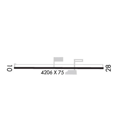
Runway Identifications
Runway Identification: 10/28
Length: 4206 ft
Width: 75 ft
Surface: ASPHALT-GOOD CONDITION
Edge lights:

Treatment: NONE

 Runway: 10   Runway: 28
Mag heading: 102°Mag heading: 282°
Rwy Slope: .15% UpRwy Slope: -.15% Down
Approach: Approach:
Pattern: Left TrafficPattern: Left Traffic
Markings: NONPRECISION INSTRUMENTMarkings: NONPRECISION INSTRUMENT
Marking Condition: POOR; MARKINGS FADEDMarking Condition: POOR; MARKINGS FADED
Arresting Dev: Arresting Dev:
Lat & Long: N4310.9  W07755.4Lat. & Long.: N4310.9  W07754.5
Elev: 656.4 ft. MSLElev: 662.5 ft. MSL
TCH: TCH:
Visual Glide Path: Visual Glide Path:
Displaced Threshold: NoDisplaced Threshold: No
Touchdown Zone: YESTouchdown Zone: YES
Touchdown Elev.: 664.9 feetTouchdown Elev.: 664.9 feet
Visual Glide Slope: Visual Glide Slope:
RVR Equipment: RVR Equipment:
RVV Equipment: NORVV Equipment: NO
Approach Lights: Approach Lights:
REIL: NOREIL: NO
Centerline Lights: NOCenterline Lights: NO
Touchdown lights: NOTouchdown lights: NO
Runway Category: Runway with a Visual ApproachRunway Category: Runway with a Non-precision Approach
Declared Distances: Declared Distances:
Obstructions: BRUSHObstructions: TREES; RY 28 HAS TREES ON BOTH SIDES OF CNTRLN, +32 TO +50 FT HIGH, 750 - 900 FT FROM RY END
Marked: NOT Marked/LightedMarked: NOT Marked/Lighted
Clearance slope: 5:1Clearance slope: 15:1
Obstruction height: 18 feet AGLObstruction height: 37 feet AGL
Dist. from runway: 292 feetDist. from runway: 759 feet
Centerline offset: Centerline offset: 148 feet left of centerline
Comments: RWY 10, +5 FT ELECTRICAL BOXES 81 FT OUT AND 100 FT LEFT; +11 TO +16FT TREES, 104 -160FT FRM RWY, 172 - 183FT RT.Comments: RY 28 HAS +5 FT ELECTRIC BOXES 61 FT FM RY END AND 100 FT RIGHT; +20 TO +33FT TREES, 13 - 32FT FRM RNWY,114 - 123FT LEFT.
C:/P: