Click here for more info on on SMS!

K7B2

NORTHAMPTON
NORTHAMPTON
MA
Time Zone: Eastern
Lat: N 4219.7
Long: W 07236.7
Elev: 121
Var: +15
Longest Runway: 3335
Clr Del: 133.6
CTAF: 122.7

FBO & Flight Services info for K7B2

FBOs: Update your Fuel Prices
Located on the scenic Connecticut River, the Northampton Airport (7B2) has a 3365' runway with a 24-hour self-service 100 LL fuel stop, fully-licensed flight school, airplane rentals, certified maintenance department and FBO office.
Ph: 413-584-7980 Fax: 413.387.6335 Freq: 122.7Website-
Service
Jet
100LL
SAF
MoGas
Full        Caution: Fuel prices have not been updated in 32 days.
Last Update: 03/18/2024 10:17

Self  6.25    
Misc. Info: Address: 160 OLD FERRY RD   NORTHAMPTON, MA 01060

If you are an FBO, call 1-203-262-1700 to update your info or email: FltPlan.Advertising@garmin.com
Advertise your FBO on FltPlan.com

Runway & Approach Info for K7B2
Rwy
Length
Land Dist**
Approach*
  Rwy
Length
Land Dist**
Approach*
14
3335x50  3335'          
 
  
32
  3335x50  3115'          
 
 * only ILS, LOC, LDA, and SDF approaches to a specific runway are shown
** For any Declared Landing Distance Available, please see A/FD or Approach plates
Runway Weight Capability (lbs.) Help
Runway IDSingle WheelDouble WheelDouble Tandem WheelDual Double Wheel
14/327,500N/AN/AN/A
These numbers are Advisory and are not limits.   The Airport Manager should have more accurate Weight Limits
Approach Charts
Approaches    
Current Weather/Notams
Customs Information Send updates to Support@FltPlan.com
Customs Not Available
Database effective 04/18/2024
Airport Diagram of K7B2
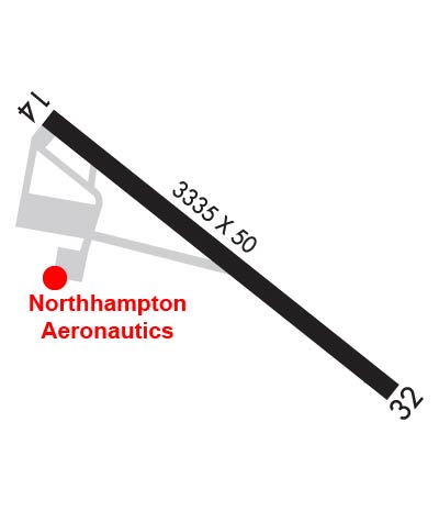
Airport Diagram might not be current.

Facility Name: NORTHAMPTON
City Name: NORTHAMPTON
County: HAMPSHIRE
State abbrev: MA
State Name: MASSACHUSETTS
   
Ownership: PRIVATELY OWNED
Use: OPEN TO THE PUBLIC
Owner's Name: SEVEN BRAVO TWO, LLC
Address: 160 OLD FERRY RD
 NORTHAMPTON, MA 01060
Owner's Phone: 413-568-0905
  
Manager's Name: RICHARD MACISAAC
Address: 160 OLD FERRY RD
 NORTHAMPTON, MA 01060
Phone: 860-833-7602; RICHM@FLY7B2.COM
   
FAA Region: NEW ENGLAND
FAA Field Office: NONE


Sunrise / Sunset times for NORTHAMPTON

DateSunriseSunset
04/18/24 Thursday6:0419:36
04/19/24 Friday6:0219:37
04/20/24 Saturday6:0119:39
04/21/24 Sunday5:5919:40
04/22/24 Monday5:5819:41
04/23/24 Tuesday5:5619:42
04/24/24 Wednesday5:5519:43
04/25/24 Thursday5:5319:44
04/26/24 Friday5:5219:45
04/27/24 Saturday5:5019:46
04/28/24 Sunday5:4919:47
04/29/24 Monday5:4719:49
04/30/24 Tuesday5:4619:50
05/01/24 Wednesday5:4519:51

Airport Facilities

Airport Attendance Schedule7 Days A Week 0800-1800
Airport Status OPERATIONAL (This Status can change at any time - please check NOTAMS)
Airport Lighting ScheduleACTVT MIRL RWY 14/32 - CTAF.
Airport Storage AvailableTie Downs, Hanger
Extra Services AvailableFlight Instruction, Aircraft Rental
Wind IndicatorYES - (lighted)
Control TowerNO
CTAF Frequency122.700
Unicom Frequency122.700
Rotating Beacon ColorWG
Segmented CircleNO
Landing FeeNO

Airport Inspection Data

Airport InspectedSTATE - performed by STATE AERONAUTICAL PERSONNEL
Inspection Date05/20/2022

Airport Services

Type of Fuel AvailableGrade 100LL; -10FUEL IS 24 HR SELF-SERVE.
Airframe Repair ServiceMAJOR
Power Plant Repair ServiceMAJOR

Geographic Data

LatitudeN4219.7
LongitudeW07236.7 (ESTIMATED)
Arpt Elevation121ft (SURVEYED)
Magnetic Variation15W
1 miles NEof NORTHAMPTON
Traffic Pattern Altitude
Sectional ChartNEW YORK

Aircraft Data

Operations (Reported)YearlyAvg. Daily
General Aviation Transient 11003
General Aviation Local 41000112
Air Taxi 2001
Commerical 00
Commuter 00
Military 1500
Aircraft based on Field
General Aviation Singles 77
General Aviation Multi 4
Jet Aircraft 0
General Aviation Helicopters 1
Military Aircraft 0
Gliders 2
Ultralights 0

FAA Services

FSS on field NO
FSS tie-in BURLINGTON
FSS Phone 1-800-WX-BRIEF
Who issues Notams BTV
Notam D service at airport YES
ARTCC Name BOSTON

Federal Status

Airport Certification
Aircraft Rescue & Firefighting IndexNone
Airport of EntryNo
Custom Landing RightsNo
Joint Civil/MilitaryNo
Military Landing rightsNo

Federal Agreements

NATIONAL PLAN OF INTEGRATED AIRPORT SYSTEMS (NPIAS)

Remarks

THIS AIRPORT HAS BEEN SURVEYED BY THE NATIONAL GEODETIC SURVEY.
ARPT CLSD TO ALL ACFT & HEL CRTFYD FOR 12500 LBS & OVR.
LDG FEE FOR COML ACFT.
FEE & PPR FOR COML BLN OPS.
FOR CD CTC YANKEE APCH AT 860-386-3597.
GLDR ACT ON & INVOF ARPT MAY-OCT.
(PAY PHONE) PAY PHONE AVAILABLE.
Airport Communications & Frequencies:
Clearance Delivery Frequencies:
133.6
CTAF Frequency:
122.700
Unicom Frequency:
122.700
BRADLEY Primary Approach Frequencies:  
125.35
281.5
BRADLEY Primary Departure Frequencies:  
125.35
281.5
Runway Identifications
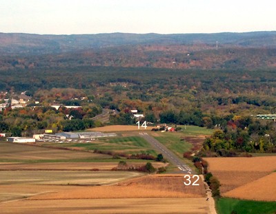
Runway Identification: 14/32
Length: 3335 ft
Width: 50 ft
Surface: ASPHALT-GOOD CONDITION
Edge lights: Medium Intensity

Treatment: NONE

 Runway: 14   Runway: 32
Mag heading: 143°Mag heading: 323°
Rwy Slope: -.08% DownRwy Slope: .08% Up
Approach: Approach:
Pattern: Left TrafficPattern: Left Traffic
Markings: BASICMarkings: BASIC
Marking Condition: GOODMarking Condition: GOOD
Arresting Dev: Arresting Dev:
Lat & Long: N4219.8  W07237.0Lat. & Long.: N4219.5  W07236.4
Elev: 121.4 ft. MSLElev: 118.8 ft. MSL
TCH: 60 ft. AGLTCH:
Visual Glide Path: 4.50 degreesVisual Glide Path:
Displaced Threshold: NoDisplaced Threshold: 220 feet
Touchdown Zone: YESTouchdown Zone: YES
Touchdown Elev.: 121.4 feetTouchdown Elev.: 119.3 feet
Visual Glide Slope: 4-Light PAPI on LEFT side of RunwayVisual Glide Slope:
RVR Equipment: RVR Equipment:
RVV Equipment: NORVV Equipment: NO
Approach Lights: Approach Lights:
REIL: NOREIL: NO
Centerline Lights: NOCenterline Lights: NO
Touchdown lights: NOTouchdown lights: NO
Runway Category: Runway with a Visual ApproachRunway Category: Runway with a Visual Approach
Declared Distances: Declared Distances:
Obstructions: TREESObstructions: TREES
Marked: NOT Marked/LightedMarked: NOT Marked/Lighted
Clearance slope: 6:1Clearance slope: 25:1; APCH 38:1 TO DTHR.
Obstruction height: 60 feet AGLObstruction height: 32 feet AGL
Dist. from runway: 600 feetDist. from runway: 1000 feet
Centerline offset: 210 right of centerlineCenterline offset: 51 feet right of centerline
Comments: 15 FT ROAD IN PRIM SFC.Comments: ROAD IN PRIM SFC 50 FT FM THR.
C:1/P: