Click here for more info on on SMS!

K79J

SOUTH ALABAMA RGNL
ANDALUSIA
AL
Time Zone: Central
Lat: N 3118.5
Long: W 08623.5
Elev: 310
Var: +02
Longest Runway: 6000
AWOS: 134.87
CTAF: 122.8

FBO & Flight Services info for K79J

FBOs: Update your Fuel Prices
Providing high quality fuel and services to you and your customers, from Phillips 66 Aviation.
Ph: 334-222-6598 Fax: 334-222-1242 Freq: 122.8Website-
                   
Service
Jet
100LL
SAF
MoGas
Full        Caution: Fuel prices have not been updated in 31 days.
Last Update: 03/24/2024 10:31

Self        
Misc. Info: Address: 21861 BILL BENTON LANE   ANDALUSIA, AL 36421

ASOSPh: 334-222-9770
-
Freq: 134.87  
If you are an FBO, call 1-203-262-1700 to update your info or email: FltPlan.Advertising@garmin.com
Advertise your FBO on FltPlan.com

Runway & Approach Info for K79J
Rwy
Length
Land Dist**
Approach*
  Rwy
Length
Land Dist**
Approach*
11
6000x100  6000'          
 
  
29
  6000x100  6000'          
 
 * only ILS, LOC, LDA, and SDF approaches to a specific runway are shown
** For any Declared Landing Distance Available, please see A/FD or Approach plates
Runway Weight Capability (lbs.) Help
Runway IDSingle WheelDouble WheelDouble Tandem WheelDual Double Wheel
11/2998,000160,000275,000N/A
These numbers are Advisory and are not limits.   The Airport Manager should have more accurate Weight Limits
Approach Charts
Approaches    
Current Weather/Notams
Customs Information Send updates to Support@FltPlan.com
Customs Not Available
Database effective 05/16/2024
Airport Diagram of K79J
Airport Diagram might not be current.
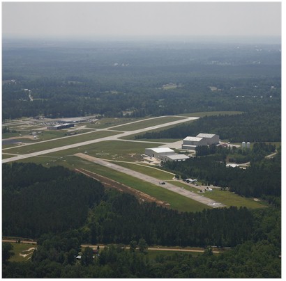
Facility Name: SOUTH ALABAMA RGNL AT BILL BENTON FLD
City Name: ANDALUSIA
County: COVINGTON
State abbrev: AL
State Name: ALABAMA
   
Ownership: PUBLICLY OWNED
Use: OPEN TO THE PUBLIC
Owner's Name: ANDALUSIA ARPT AUTH
Address: 21861 BILL BENTON LANE
 ANDALUSIA, AL 36421
Owner's Phone: 334-222-6598
  
Manager's Name: JED BLACKWELL; JED BLACKWELL
Address: 21861 BILL BENTON LANE
 ANDALUSIA, AL 36421
Phone: 334-222-6598
   
FAA Region: SOUTHERN
FAA Field Office: JAN


Sunrise / Sunset times for SOUTH ALABAMA RGNL AT BILL BENTON FLD

DateSunriseSunset
04/23/24 Tuesday6:0819:20
04/24/24 Wednesday6:0719:21
04/25/24 Thursday6:0619:21
04/26/24 Friday6:0519:22
04/27/24 Saturday6:0419:23
04/28/24 Sunday6:0319:23
04/29/24 Monday6:0219:24
04/30/24 Tuesday6:0119:25
05/01/24 Wednesday6:0019:26
05/02/24 Thursday5:5919:26
05/03/24 Friday5:5819:27
05/04/24 Saturday5:5719:28
05/05/24 Sunday5:5719:28
05/06/24 Monday5:5619:29

Airport Facilities

Airport Attendance ScheduleSAT-SUN 0730-1630, MON - FRI 0630-0000; AFT HRS SVC CALL 334-222-0638/334-427-0733
Airport Status OPERATIONAL (This Status can change at any time - please check NOTAMS)
Airport Lighting ScheduleACTVT PAPI RWY 11 & 29; MIRL RWY 11/29 - CTAF.
Airport Storage AvailableTie Downs
Extra Services AvailableFlight Instruction
Wind IndicatorYES - (lighted)
Control TowerNO
CTAF Frequency122.800
Unicom Frequency122.800
Rotating Beacon ColorWG
Segmented CircleYES
Landing FeeNO

Airport Inspection Data

Airport InspectedSTATE - performed by STATE AERONAUTICAL PERSONNEL
Inspection Date03/21/2022

Airport Services

Type of Fuel AvailableGrade 100LL, JET A; -10100LL SELF SERVE AVBL 24 HRS.; -A+MILITARY CONTRACT FUEL AVBL MON-FRI 0700-2400, OTHER TIMES CALL (334) 222-0638
Airframe Repair ServiceMAJOR
Power Plant Repair ServiceMAJOR

Geographic Data

LatitudeN3118.5
LongitudeW08623.5 (ESTIMATED)
Arpt Elevation310ft (SURVEYED)
Magnetic Variation02W
4 miles Eof ANDALUSIA
Traffic Pattern Altitude
Sectional ChartNEW ORLEANS

Aircraft Data

Operations (Reported)YearlyAvg. Daily
General Aviation Transient 1141331
General Aviation Local 19505
Air Taxi 00
Commerical 00
Commuter 00
Military 52337143
Aircraft based on Field
General Aviation Singles 20
General Aviation Multi 2
Jet Aircraft 1
General Aviation Helicopters 3
Military Aircraft 0
Gliders 0
Ultralights 0

FAA Services

FSS on field NO
FSS tie-in ANNISTON
FSS Phone 1-800-WX-BRIEF
Who issues Notams 79J
Notam D service at airport YES
ARTCC Name JACKSONVILLE

Federal Status

Airport Certification
Aircraft Rescue & Firefighting IndexNone
Airport of EntryNo
Custom Landing RightsNo
Joint Civil/MilitaryNo
Military Landing rightsYES

Federal Agreements

NATIONAL PLAN OF INTEGRATED AIRPORT SYSTEMS (NPIAS)
GRANT AGREEMENTS UNDER FAAP/ADAP/AIP
ASSURANCES PURSUANT TO TITLE VI, CIVIL RIGHTS ACT OF 1964

Remarks

THIS AIRPORT HAS BEEN SURVEYED BY THE NATIONAL GEODETIC SURVEY.
FOR CD CTC CAIRNS APCH AT 334-255-8402, WHEN APCH CLSD CTC JACKSONVILLE ARTCC AT 904-845-1592.
Airport Communications & Frequencies:
CTAF Frequency:
122.800
Unicom Frequency:
122.800
Remarks
  • APCH/DEP SVC PRVDD BY JACKSONVILLE ARTCC ON FREQS 134.3/322.55 (DOTHAN RCAG) WHEN CAIRNS APCH/DEP CLSD.
  • CAIRNS Primary Approach Frequencies:  
    133.45
    239.275
    CAIRNS Primary Departure Frequencies:  
    133.45
    239.275
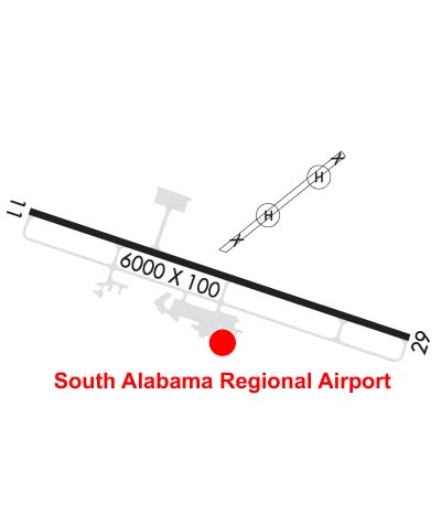
    Runway Identifications
    Runway Identification: 11/29
    Length: 6000 ft
    Width: 100 ft
    Surface: ASPHALT-GOOD CONDITION
    Edge lights: Medium Intensity

    Treatment: NONE

     Runway: 11   Runway: 29
    Mag heading: 109°Mag heading: 289°
    Rwy Slope: -.17% DownRwy Slope: .17% Up
    Approach: Approach:
    Pattern: Left TrafficPattern: Left Traffic
    Markings: NONPRECISION INSTRUMENTMarkings: NONPRECISION INSTRUMENT
    Marking Condition: FAIR; MARKINGS FAIR DUE TO FADINGMarking Condition: GOOD
    Arresting Dev: Arresting Dev:
    Lat & Long: N3118.6  W08624.1Lat. & Long.: N3118.4  W08623.0
    Elev: 309.9 ft. MSLElev: 299.9 ft. MSL
    TCH: 33 ft. AGLTCH: 47 ft. AGL
    Visual Glide Path: 3.00 degreesVisual Glide Path: 3.50 degrees
    Displaced Threshold: NoDisplaced Threshold: No
    Touchdown Zone: YESTouchdown Zone: YES
    Touchdown Elev.: 310.2 feetTouchdown Elev.: 308.3 feet
    Visual Glide Slope: 4-Light PAPI on RIGHT side of RunwayVisual Glide Slope: 4-Light PAPI on LEFT side of Runway
    RVR Equipment: RVR Equipment:
    RVV Equipment: NORVV Equipment: NO
    Approach Lights: Approach Lights:
    REIL: YESREIL: YES
    Centerline Lights: NOCenterline Lights: NO
    Touchdown lights: NOTouchdown lights: NO
    Runway Category: Runway with a Non-precision Approach having visibility minimums greater than 3/4 mileRunway Category: Runway with a Non-precision Approach having visibility minimums greater than 3/4 mile
    Declared Distances: Declared Distances:
    Obstructions: TREEObstructions: TREE
    Marked: NOT Marked/LightedMarked: NOT Marked/Lighted
    Clearance slope: 24:1Clearance slope: 26:1
    Obstruction height: 105 feet AGLObstruction height: 82 feet AGL
    Dist. from runway: 2797 feetDist. from runway: 2404 feet
    Centerline offset: 98 right of centerlineCenterline offset: 55 feet left of centerline
    Comments: Comments:
    C:9/P: