Current Weather/Notams (Metars, TAFs, Notams, NWS Forecast, PIREPS, and nearby weather)
Customs Information Send updates to Support@FltPlan.com
Customs Not Available
Database effective 04/18/2024
Airport Diagram might not be current.
|
| Facility Name: | MARLETTE TOWNSHIP |
| City Name: | MARLETTE |
| County: | SANILAC |
| State abbrev: | MI |
| State Name: | MICHIGAN |
| | |
| Ownership: | PUBLICLY OWNED |
| Use: | OPEN TO THE PUBLIC |
| Owner's Name: | MARLETTE TOWNSHIP |
| Address: | 6725 AIRPORT RD |
| | MARLETTE, MI 48453-8210 |
| Owner's Phone: | 989-635-7772 |
| | |
| Manager's Name: | PHIL ROACH |
| Address: | 6725 AIRPORT RD |
| | MARLETTE, MI 48453-8210 |
| Phone: | 810-459-4674 |
| | |
| FAA Region: | GREAT LAKES |
| FAA Field Office: | DET |
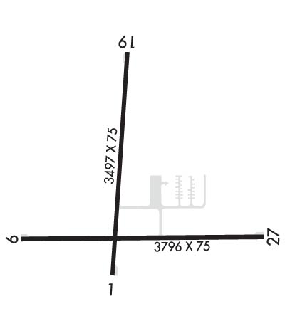
Runway Identifications
Runway Identification: 01/19Length: 3500 ft
Width: 75 ft
Surface: ASPHALT-GOOD CONDITION
Edge lights: Medium IntensityTreatment: NONE
| | Runway: 01 | | Runway: 19 |
| Mag heading: | 12° | Mag heading: | 192° |
| Rwy Slope: | .69% Up | Rwy Slope: | -.69% Down |
| Approach: | | Approach: | |
| Pattern: | Left Traffic | Pattern: | Left Traffic |
| Markings: | NONPRECISION INSTRUMENT | Markings: | NONPRECISION INSTRUMENT |
| Marking Condition: | GOOD | Marking Condition: | GOOD |
| Arresting Dev: | | Arresting Dev: | |
| Lat & Long: | N4318.5 W08305.5 | Lat. & Long.: | N4319.1 W08305.5 |
| Elev: | 870.8 ft. MSL | Elev: | 894.9 ft. MSL |
| TCH: | 21 ft. AGL | TCH: | 40 ft. AGL |
| Visual Glide Path: | 3.00 degrees | Visual Glide Path: | 3.00 degrees |
| Displaced Threshold: | No | Displaced Threshold: | No |
| Touchdown Zone: | YES | Touchdown Zone: | YES |
| Touchdown Elev.: | 891.6 feet | Touchdown Elev.: | 894.9 feet |
| Visual Glide Slope: | 2-Light PAPI on LEFT side of Runway | Visual Glide Slope: | 2-Light PAPI on LEFT side of Runway |
| RVR Equipment: | | RVR Equipment: | |
| RVV Equipment: | NO | RVV Equipment: | NO |
| Approach Lights: | | Approach Lights: | |
| REIL: | NO | REIL: | NO |
| Centerline Lights: | NO | Centerline Lights: | NO |
| Touchdown lights: | NO | Touchdown lights: | NO |
| Runway Category: | Runway with a Visual Approach | Runway Category: | Runway with a Non-precision Approach |
| Declared Distances: | | Declared Distances: | |
| Obstructions: | 0-8 FT SEASONAL CROPS, 230 FT DIST. | Obstructions: | TREE |
| Marked: | NOT Marked/Lighted | Marked: | NOT Marked/Lighted |
| Clearance slope: | 20:1 | Clearance slope: | 5:1 |
| Obstruction height: | | Obstruction height: | 26 feet AGL |
| Dist. from runway: | | Dist. from runway: | 345 feet |
| Centerline offset: | | Centerline offset: | 130 feet left of centerline |
| Comments: | | Comments: | |
Runway Identification: 10/28Length: 3795 ft
Width: 75 ft
Surface: ASPHALT-FAIR CONDITION
Edge lights: Medium IntensityTreatment: NONE
| | Runway: 10 | | Runway: 28 |
| Mag heading: | 97° | Mag heading: | 277° |
| Rwy Slope: | .20% Up | Rwy Slope: | -.20% Down |
| Approach: | | Approach: | |
| Pattern: | Left Traffic | Pattern: | Left Traffic |
| Markings: | NONPRECISION INSTRUMENT | Markings: | NONPRECISION INSTRUMENT |
| Marking Condition: | GOOD | Marking Condition: | GOOD |
| Arresting Dev: | | Arresting Dev: | |
| Lat & Long: | N4318.6 W08305.8 | Lat. & Long.: | N4318.6 W08305.0 |
| Elev: | 871.7 ft. MSL | Elev: | 879.2 ft. MSL |
| TCH: | 44 ft. AGL | TCH: | 45 ft. AGL |
| Visual Glide Path: | 3.00 degrees | Visual Glide Path: | 3.00 degrees |
| Displaced Threshold: | No | Displaced Threshold: | No |
| Touchdown Zone: | YES | Touchdown Zone: | YES |
| Touchdown Elev.: | 880.7 feet | Touchdown Elev.: | 880.7 feet |
| Visual Glide Slope: | 2-Light PAPI on RIGHT side of Runway | Visual Glide Slope: | 2-Light PAPI on LEFT side of Runway |
| RVR Equipment: | | RVR Equipment: | |
| RVV Equipment: | NO | RVV Equipment: | NO |
| Approach Lights: | | Approach Lights: | |
| REIL: | NO | REIL: | NO |
| Centerline Lights: | NO | Centerline Lights: | NO |
| Touchdown lights: | NO | Touchdown lights: | NO |
| Runway Category: | Runway with a Non-precision Approach | Runway Category: | Runway with a Non-precision Approach |
| Declared Distances: | | Declared Distances: | |
| Obstructions: | | Obstructions: | TREE |
| Marked: | | Marked: | NOT Marked/Lighted |
| Clearance slope: | 20:1 | Clearance slope: | 14:1 |
| Obstruction height: | | Obstruction height: | 28 feet AGL |
| Dist. from runway: | | Dist. from runway: | 595 feet |
| Centerline offset: | | Centerline offset: | 180 feet right of centerline |
| Comments: | | Comments: | |

