
| ||||||||||||||||||||||||||||||||||||||||||||
| ||||||||||||||||||||||||||||||||||||||||||||
| ||||||||||||||||||||||||||||||||||||||||||||
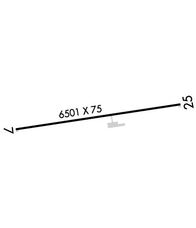
| Rwy | Rwy | |||||||
| 6501x75 | 6501' | 6501x75 | 6501' | |||||
| Runway ID | Single Wheel | Double Wheel | Double Tandem Wheel | Dual Double Wheel |
| 07/25 | 30,000 | 60,000 | N/A | N/A |
| These numbers are Advisory and are not limits. The Airport Manager should have more accurate Weight Limits | ||||
 Airport Diagram might not be current. | |
| Facility Name: | ROOSEVELT MUNI |
| City Name: | ROOSEVELT |
| County: | DUCHESNE |
| State abbrev: | UT |
| State Name: | UTAH |
| Ownership: | PUBLICLY OWNED |
| Use: | OPEN TO THE PUBLIC |
| Owner's Name: | CITY OF ROOSEVELT |
| Address: | 255 S. STATE ST. |
| ROOSEVELT, UT 84066 | |
| Owner's Phone: | 435-722-5001 |
| Manager's Name: | KIRBY WOLFINJER; PUBLIC WORKS DIR/ARPT MGR. |
| Address: | 255 S. STATE ST. |
| ROOSEVELT, UT 84066 | |
| Phone: | 435-722-5001 |
| FAA Region: | NORTHWEST MOUNTAIN |
| FAA Field Office: | DEN |
| Date | Sunrise | Sunset |
|---|---|---|
| 04/22/24 Monday | 6:31 | 20:07 |
| 04/23/24 Tuesday | 6:29 | 20:08 |
| 04/24/24 Wednesday | 6:28 | 20:09 |
| 04/25/24 Thursday | 6:26 | 20:10 |
| 04/26/24 Friday | 6:25 | 20:11 |
| 04/27/24 Saturday | 6:24 | 20:12 |
| 04/28/24 Sunday | 6:22 | 20:13 |
| 04/29/24 Monday | 6:21 | 20:14 |
| 04/30/24 Tuesday | 6:20 | 20:15 |
| 05/01/24 Wednesday | 6:19 | 20:16 |
| 05/02/24 Thursday | 6:17 | 20:17 |
| 05/03/24 Friday | 6:16 | 20:18 |
| 05/04/24 Saturday | 6:15 | 20:19 |
| 05/05/24 Sunday | 6:14 | 20:20 |
| Airport Attendance Schedule | UNATTENDED |
| Airport Status | OPERATIONAL (This Status can change at any time - please check NOTAMS) |
| Airport Lighting Schedule | ACTVT & INCR INTST REIL RWY 07 & 25; MIRL RWY 7/25 - CTAF. PAPI RWY 07 & 25 ON CONSLY. |
| Airport Storage Available | Tie Downs, Hanger |
| Extra Services Available | Flight Instruction, Aircraft Rental |
| Wind Indicator | YES - (lighted) |
| Control Tower | NO |
| CTAF Frequency | 122.800 |
| Unicom Frequency | 122.800 |
| Rotating Beacon Color | WG |
| Segmented Circle | YES |
| Landing Fee | NO |
| Airport Inspected | STATE - performed by PRIVATE CONTRACT PERSONNEL |
| Inspection Date | 09/17/2023 |
| Type of Fuel Available | Grade 100LL, JET A (freeze point -40C) |
| Airframe Repair Service | MAJOR |
| Power Plant Repair Service | MAJOR |
| Latitude | N4016.7 |
| Longitude | W11003.1 (ESTIMATED) |
| Arpt Elevation | 5176ft (SURVEYED) |
| Magnetic Variation | 10E |
| 3 miles SW | of ROOSEVELT |
| Traffic Pattern Altitude | |
| Sectional Chart | SALT LAKE CITY |
| Operations (Reported) | Yearly | Avg. Daily |
|---|---|---|
| General Aviation Transient | 3602 | 10 |
| General Aviation Local | 1557 | 4 |
| Air Taxi | 60 | 0 |
| Commerical | 0 | 0 |
| Commuter | 0 | 0 |
| Military | 0 | 0 |
| Aircraft based on Field | |
|---|---|
| General Aviation Singles | 20 |
| General Aviation Multi | 1 |
| Jet Aircraft | 0 |
| General Aviation Helicopters | 0 |
| Military Aircraft | 0 |
| Gliders | 0 |
| Ultralights | 0 |
| FSS on field | NO |
| FSS tie-in | CEDAR CITY |
| FSS Phone | 1-800-WX-BRIEF |
| Who issues Notams | CDC |
| Notam D service at airport | YES |
| ARTCC Name | SALT LAKE CITY |
| Airport Certification | |
| Aircraft Rescue & Firefighting Index | None |
| Airport of Entry | No |
| Custom Landing Rights | No |
| Joint Civil/Military | No |
| Military Landing rights | YES |
| NATIONAL PLAN OF INTEGRATED AIRPORT SYSTEMS (NPIAS) |
| GRANT AGREEMENTS UNDER FAAP/ADAP/AIP |
| ASSURANCES PURSUANT TO TITLE VI, CIVIL RIGHTS ACT OF 1964 |
Airport Communications & Frequencies:
| |||||||||
| Runway: 07 | Runway: 25 | ||
| Mag heading: | 73° | Mag heading: | 253° |
| Rwy Slope: | -1.02% Down | Rwy Slope: | 1.02% Up |
| Approach: | Approach: | ||
| Pattern: | Left Traffic | Pattern: | Left Traffic |
| Markings: | NONPRECISION INSTRUMENT | Markings: | NONPRECISION INSTRUMENT |
| Marking Condition: | GOOD | Marking Condition: | GOOD |
| Arresting Dev: | Arresting Dev: | ||
| Lat & Long: | N4016.6 W11003.8 | Lat. & Long.: | N4016.8 W11002.4 |
| Elev: | 5176.1 ft. MSL | Elev: | 5110.1 ft. MSL |
| TCH: | 40 ft. AGL | TCH: | 40 ft. AGL |
| Visual Glide Path: | 3.00 degrees | Visual Glide Path: | 3.00 degrees |
| Displaced Threshold: | No | Displaced Threshold: | No |
| Touchdown Zone: | YES | Touchdown Zone: | YES |
| Touchdown Elev.: | 5176.1 feet | Touchdown Elev.: | 5140.5 feet |
| Visual Glide Slope: | 4-Light PAPI on LEFT side of Runway | Visual Glide Slope: | 4-Light PAPI on LEFT side of Runway |
| RVR Equipment: | RVR Equipment: | ||
| RVV Equipment: | NO | RVV Equipment: | NO |
| Approach Lights: | Approach Lights: | ||
| REIL: | YES | REIL: | YES |
| Centerline Lights: | NO | Centerline Lights: | NO |
| Touchdown lights: | NO | Touchdown lights: | NO |
| Runway Category: | Runway with a Visual Approach | Runway Category: | Runway with a Non-precision Approach |
| Declared Distances: | Declared Distances: |
