Click here for more info on on SMS!

K74S

ANACORTES
ANACORTES
WA
Time Zone: Pacific
Lat: N 4829.9
Long: W 12239.7
Elev: 246
Var: -21
Longest Runway: 3018
CTAF: 128.25

FBO & Flight Services info for K74S

FBOs: Update your Fuel Prices
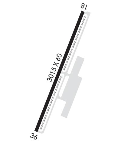
Important features of the facility are: Runway length: 3,018 ft., Runway width: 60 ft., Airport elevation 242 ft., Airport reference point: 48B029'57, Effective runway gradient: 0.27, Lighting - Runway & Taxiway: Medium Intensity, Visual approach aids: PAPI each end, Wind coverage: 89.3, Mean maximum temperature: 72.6, Super AWOS info 122.9
Ph: 360-299-1828
-
Freq: 128.25WebsiteE-Mail
Service
Jet
100LL
SAF
MoGas
Fuel Avail: 24-hour self service
Full        Last Update: 03/28/2024 14:00
PRICES GUARANTEED by FBO.
Self4.945.83    
Misc. Info: Address: 4000 AIRPORT ROAD A, ANACORTES WA 98221

If you are an FBO, call 1-203-262-1700 to update your info or email: FltPlan.Advertising@garmin.com
Advertise your FBO on FltPlan.com

Runway & Approach Info for K74S
Rwy
Length
Land Dist**
Approach*
  Rwy
Length
Land Dist**
Approach*
18
3018x60  3018'          
 
  
36
  3018x60  3018'          
 
 * only ILS, LOC, LDA, and SDF approaches to a specific runway are shown
** For any Declared Landing Distance Available, please see A/FD or Approach plates
Runway Weight Capability (lbs.) Help
Runway IDSingle WheelDouble WheelDouble Tandem WheelDual Double Wheel
18/3612,500N/AN/AN/A
These numbers are Advisory and are not limits.   The Airport Manager should have more accurate Weight Limits
Approach Charts
FltPlan does not have IFR approach charts available for K74S.
Current Weather/Notams
Customs Information Send updates to Support@FltPlan.com
Phone 360-293-2331
Fax N/A

Comments 2 hrs advance notice required. Business hrs 0800-1700 7 days a week. *Maximum passengers per flight: 15 *Call prior to 1700 for after-hours service.
Database effective 04/18/2024
Airport Diagram of K74S
Airport Diagram might not be current.

Facility Name: ANACORTES
City Name: ANACORTES
County: SKAGIT
State abbrev: WA
State Name: WASHINGTON
   
Ownership: PUBLICLY OWNED
Use: OPEN TO THE PUBLIC
Owner's Name: PORT OF ANACORTES
Address: 100 COMMERCIAL AVENUE
 ANACORTES, WA 98221
Owner's Phone: 360-293-3134
  
Manager's Name: JOHN DUMAS
Address: 100 COMMERCIAL AVENUE
 ANACORTES, WA 98221
Phone: 360-293-3134
   
FAA Region: NORTHWEST MOUNTAIN
FAA Field Office: SEA


Sunrise / Sunset times for ANACORTES

DateSunriseSunset
04/19/24 Friday6:1120:09
04/20/24 Saturday6:0920:10
04/21/24 Sunday6:0720:12
04/22/24 Monday6:0520:13
04/23/24 Tuesday6:0420:15
04/24/24 Wednesday6:0220:16
04/25/24 Thursday6:0020:18
04/26/24 Friday5:5820:19
04/27/24 Saturday5:5620:21
04/28/24 Sunday5:5520:22
04/29/24 Monday5:5320:24
04/30/24 Tuesday5:5120:25
05/01/24 Wednesday5:5020:26
05/02/24 Thursday5:4820:28

Airport Facilities

Airport Attendance ScheduleUNATTENDED
Airport Status OPERATIONAL (This Status can change at any time - please check NOTAMS)
Airport Lighting ScheduleACTVT MIRL & REILS RY 18/36 - CTAF.
Airport Storage AvailableTie Downs
Extra Services AvailableAir Freight, Air Ambulance, Charter
Wind IndicatorYES - (lighted)
Control TowerNO
CTAF Frequency128.250; AUTOMATED UNICOM; 122.9. ADZY ALSO AVBL AT 617-262-3825.
Unicom Frequency
Rotating Beacon ColorWG
Segmented CircleYES
Landing FeeNO

Airport Inspection Data

Airport InspectedSTATE - performed by STATE AERONAUTICAL PERSONNEL
Inspection Date09/05/2023

Airport Services

Type of Fuel AvailableGrade 100, JET A (freeze point -40C)
Airframe Repair ServiceNONE
Power Plant Repair ServiceNONE

Geographic Data

LatitudeN4829.9
LongitudeW12239.7 (ESTIMATED)
Arpt Elevation246ft (SURVEYED)
Magnetic Variation21E
2 miles Wof ANACORTES
Traffic Pattern Altitude
Sectional ChartSEATTLE

Aircraft Data

Operations (Reported)YearlyAvg. Daily
General Aviation Transient 400011
General Aviation Local 350010
Air Taxi 15004
Commerical 00
Commuter 00
Military 00
Aircraft based on Field
General Aviation Singles 28
General Aviation Multi 0
Jet Aircraft 0
General Aviation Helicopters 0
Military Aircraft 0
Gliders 0
Ultralights 0

FAA Services

FSS on field NO
FSS tie-in SEATTLE
FSS Phone 1-800-WX-BRIEF
Who issues Notams SEA
Notam D service at airport YES
ARTCC Name SEATTLE

Federal Status

Airport Certification
Aircraft Rescue & Firefighting IndexNone
Airport of EntryNo
Custom Landing RightsYES
Joint Civil/MilitaryNo
Military Landing rightsYES

Federal Agreements

NATIONAL PLAN OF INTEGRATED AIRPORT SYSTEMS (NPIAS)
GRANT AGREEMENTS UNDER FAAP/ADAP/AIP
ASSURANCES PURSUANT TO TITLE VI, CIVIL RIGHTS ACT OF 1964

Remarks

MILITARY ARRIVAL CORRIDOR N & W OF ARPT.
RWY 36 PREFERRED CALM WIND RY.
NOISE ABATEMENT PROCEDURES IN EFFECT; CTC AMGR 360-293-3134.
NO TOUCH & GO LDGS.
FOR CD CTC WHIDBEY APCH AT 360-257-3310.
DEER AND COYOTE NEAR MOV AREAS.
Runway Identifications
Runway Identification: 18/36
Length: 3018 ft
Width: 60 ft
Surface: ASPHALT-GOOD CONDITION
Edge lights: Medium Intensity

Treatment: GROOVED

 Runway: 18   Runway: 36
Mag heading: 179°Mag heading: 359°
Rwy Slope: .28% UpRwy Slope: -.28% Down
Approach: Approach:
Pattern: Right TrafficPattern: Left Traffic
Markings: BASICMarkings: BASIC
Marking Condition: FAIRMarking Condition: FAIR
Arresting Dev: Arresting Dev:
Lat & Long: N4830.1  W12239.6Lat. & Long.: N4829.7  W12239.9
Elev: 237.7 ft. MSLElev: 246.1 ft. MSL
TCH: 40 ft. AGLTCH: 43 ft. AGL
Visual Glide Path: 3.00 degreesVisual Glide Path: 3.00 degrees
Displaced Threshold: NoDisplaced Threshold: No
Touchdown Zone: YESTouchdown Zone: YES
Touchdown Elev.: 246.0 feetTouchdown Elev.: 246.1 feet
Visual Glide Slope: 4-Light PAPI on RIGHT side of RunwayVisual Glide Slope: 4-Light PAPI on LEFT side of Runway
RVR Equipment: RVR Equipment:
RVV Equipment: NORVV Equipment: NO
Approach Lights: Approach Lights:
REIL: YESREIL: YES
Centerline Lights: NOCenterline Lights: NO
Touchdown lights: NOTouchdown lights: NO
Runway Category: Runway with a Visual ApproachRunway Category: Runway with a Visual Approach
Declared Distances: Declared Distances:
Obstructions: TREEObstructions: TREES
Marked: NOT Marked/LightedMarked: NOT Marked/Lighted
Clearance slope: 25:1Clearance slope: 46:1
Obstruction height: 22 feet AGLObstruction height: 20 feet AGL
Dist. from runway: 767 feetDist. from runway: 1158 feet
Centerline offset: Centerline offset:
Comments: Comments:
C:2/P: