Click here for more info on on SMS!

K74N

BENDIGO
TOWER CITY
PA
Time Zone: Eastern
Lat: N 4033.5
Long: W 07633.6
Elev: 791
Var: +11
Longest Runway: 2325
CTAF: 122.9

FBO & Flight Services info for K74N

FBOs: Update your Fuel Prices

AIRPORT (UNATTND)Ph: 610-413-7428
-
-
Service
Jet
100LL
SAF
MoGas
Fuel Avail: NO FUEL AVAILABLE
Full        Last Update: 04/26/2024 00:15:42

Self        
If you are an FBO, call 1-203-262-1700 to update your info or email: FltPlan.Advertising@garmin.com
Advertise your FBO on FltPlan.com

Runway & Approach Info for K74N
Rwy
Length
Land Dist**
Approach*
  Rwy
Length
Land Dist**
Approach*
05
2325x60  2325'          
 
  
23
  2325x60  2144'          
 
 * only ILS, LOC, LDA, and SDF approaches to a specific runway are shown
** For any Declared Landing Distance Available, please see A/FD or Approach plates
Runway Weight Capability (lbs.) Help
Runway IDSingle WheelDouble WheelDouble Tandem WheelDual Double Wheel
05/2312,500N/AN/AN/A
These numbers are Advisory and are not limits.   The Airport Manager should have more accurate Weight Limits
Approach Charts
Approaches    
Current Weather/Notams
Customs Information Send updates to Support@FltPlan.com
Customs Not Available
Database effective 05/16/2024
Airport Diagram of K74N
Airport Diagram might not be current.

Facility Name: BENDIGO
City Name: TOWER CITY
County: DAUPHIN
State abbrev: PA
State Name: PENNSYLVANIA
   
Ownership: PRIVATELY OWNED
Use: OPEN TO THE PUBLIC
Owner's Name: GENE BENDIGO & HELEN BENDIGO TRUST
Address: 11079 CLARKS VALLEY RD
 TOWER CITY, PA 17980
Owner's Phone: 610-413-7428
  
Manager's Name: PAUL BENDIGO
Address: 250 DICKINSON DR.
 READING, PA 17605
Phone: 610-413-7428
   
FAA Region: EASTERN
FAA Field Office: HAR


Sunrise / Sunset times for BENDIGO

DateSunriseSunset
04/25/24 Thursday6:1219:57
04/26/24 Friday6:1119:58
04/27/24 Saturday6:0919:59
04/28/24 Sunday6:0820:00
04/29/24 Monday6:0720:01
04/30/24 Tuesday6:0520:02
05/01/24 Wednesday6:0420:03
05/02/24 Thursday6:0320:04
05/03/24 Friday6:0220:05
05/04/24 Saturday6:0120:06
05/05/24 Sunday5:5920:07
05/06/24 Monday5:5820:08
05/07/24 Tuesday5:5720:09
05/08/24 Wednesday5:5620:10

Airport Facilities

Airport Attendance ScheduleUNATTENDED UNATTENDED
Airport Status OPERATIONAL (This Status can change at any time - please check NOTAMS)
Airport Lighting ScheduleACTVT MIRL RWY 05/23 - CTAF.
Airport Storage AvailableTie Downs
Extra Services AvailableNONE
Wind IndicatorYES - (lighted)
Control TowerNO
CTAF Frequency122.900
Unicom Frequency
Rotating Beacon ColorWG
Segmented CircleNO
Landing FeeNO

Airport Inspection Data

Airport InspectedSTATE - performed by STATE AERONAUTICAL PERSONNEL
Inspection Date11/22/2023

Airport Services

Type of Fuel AvailableNone
Airframe Repair ServiceNone
Power Plant Repair ServiceNone

Geographic Data

LatitudeN4033.5
LongitudeW07633.6 (ESTIMATED)
Arpt Elevation790ft (ESTIMATED)
Magnetic Variation11W
2 miles Sof TOWER CITY
Traffic Pattern Altitude
Sectional ChartNEW YORK

Aircraft Data

Operations (Reported)YearlyAvg. Daily
General Aviation Transient 7002
General Aviation Local 19005
Air Taxi 300
Commerical 00
Commuter 00
Military 4501
Aircraft based on Field
General Aviation Singles 21
General Aviation Multi 0
Jet Aircraft 0
General Aviation Helicopters 1
Military Aircraft 0
Gliders 0
Ultralights 1

FAA Services

FSS on field NO
FSS tie-in WILLIAMSPORT
FSS Phone 1-800-WX-BRIEF
Who issues Notams IPT
Notam D service at airport YES
ARTCC Name NEW YORK

Federal Status

Airport Certification
Aircraft Rescue & Firefighting IndexNone
Airport of EntryNo
Custom Landing RightsNo
Joint Civil/MilitaryNo
Military Landing rightsNo

Remarks

160 FT LGHTD TWR 400 FT N OF RWY MIDFIELD.
RAPIDLY RISING TRRN 1500 MSL N-NW OF RWY 5. MT RIDGE 1500 MSL 1 NM S OF ARPT PARALLEL TO RWY 5/23.
FOR CD CTC HARRISBURG APCH AT 800-932-0712.
RWY 05 CLSD DLY SS-SR.
Airport Communications & Frequencies:
CTAF Frequency:
122.900
HARRISBURG Primary Approach Frequencies:  
126.45
269.45
HARRISBURG Primary Departure Frequencies:  
126.45
269.45
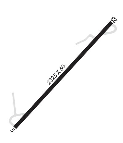
Runway Identifications
Runway Identification: 05/23
Length: 2325 ft
Width: 60 ft
Surface: CONCRETE ASPHALT-GOOD CONDITION
Edge lights: Medium Intensity

Treatment: NONE

 Runway: 05   Runway: 23
Mag heading: 53°Mag heading: 233°
Rwy Slope: .22% UpRwy Slope: -.22% Down
Approach: Approach:
Pattern: Left TrafficPattern: Left Traffic
Markings: BASICMarkings: NONSTANDARD
Marking Condition: GOODMarking Condition: GOOD
Arresting Dev: Arresting Dev:
Lat & Long: N4033.4  W07633.8Lat. & Long.: N4033.7  W07633.4
Elev: 785.6 ft. MSLElev: 790.6 ft. MSL
TCH: TCH: 25 ft. AGL
Visual Glide Path: Visual Glide Path: 3.00 degrees
Displaced Threshold: NoDisplaced Threshold: 181 feet
Touchdown Zone: YESTouchdown Zone: YES
Touchdown Elev.: 787.9 feetTouchdown Elev.: 787.9 feet
Visual Glide Slope: Visual Glide Slope: 2-Box VASI on RIGHT side of Runway; VASI OTS INDEFLY.
RVR Equipment: RVR Equipment:
RVV Equipment: NORVV Equipment: NO
Approach Lights: Approach Lights:
REIL: NOREIL: NO
Centerline Lights: NOCenterline Lights: NO
Touchdown lights: NOTouchdown lights: NO
Runway Category: Runway with a Visual ApproachRunway Category: Runway with a Visual Approach
Declared Distances: Declared Distances:
Obstructions: TREEObstructions: TREE
Marked: NOT Marked/LightedMarked: NOT Marked/Lighted
Clearance slope: 14:1Clearance slope: 10:1; APCH RATIO 29:1 TO DTHR.
Obstruction height: 36 feet AGLObstruction height: 22 feet AGL
Dist. from runway: 732 feetDist. from runway: 441 feet
Centerline offset: 89 right of centerlineCenterline offset: 135 feet left of centerline
Comments: Comments:
C:/P: