Approach Charts
| FltPlan does not have IFR approach charts available for K6V4. |
Current Weather/Notams (Metars, TAFs, Notams, NWS Forecast, PIREPS, and nearby weather)
Customs Information Send updates to Support@FltPlan.com
Customs Not Available
Database effective 05/16/2024
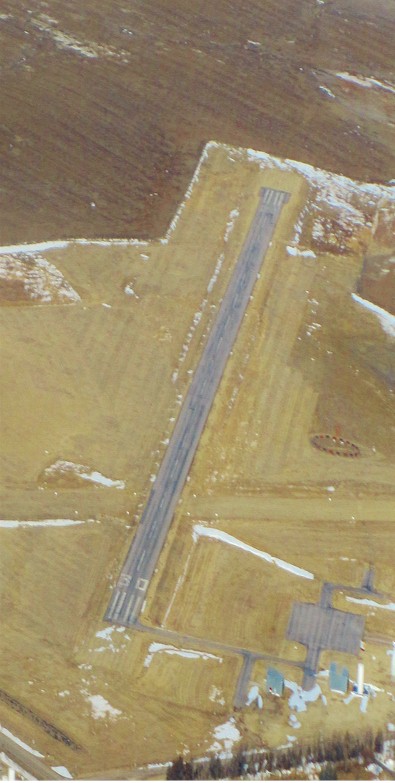
| Facility Name: | WALL MUNI |
| City Name: | WALL |
| County: | PENNINGTON |
| State abbrev: | SD |
| State Name: | SOUTH DAKOTA |
| | |
| Ownership: | PUBLICLY OWNED |
| Use: | OPEN TO THE PUBLIC |
| Owner's Name: | CITY OF WALL |
| Address: | PO BOX 314 |
| | WALL, SD 57790 |
| Owner's Phone: | 605-279-2663 |
| | |
| Manager's Name: | CITY OF WALL |
| Address: | PO BOX 314 |
| | WALL, SD 57790 |
| Phone: | 605-279-2663 |
| | |
| FAA Region: | GREAT LAKES |
| FAA Field Office: | DMA |
Runway Identifications
Runway Identification: 13/31Length: 3499 ft
Width: 60 ft
Surface: ASPHALT-FAIR CONDITION
Edge lights: Low IntensityTreatment: NONE
| | Runway: 13 | | Runway: 31 |
| Mag heading: | 125° | Mag heading: | 305° |
| Rwy Slope: | .37% Up | Rwy Slope: | -.37% Down |
| Approach: | | Approach: | |
| Pattern: | Left Traffic | Pattern: | Left Traffic |
| Markings: | BASIC | Markings: | BASIC |
| Marking Condition: | FAIR | Marking Condition: | FAIR |
| Arresting Dev: | | Arresting Dev: | |
| Lat & Long: | N4400.2 W10215.6 | Lat. & Long.: | N4359.8 W10215.0 |
| Elev: | 2799.6 ft. MSL | Elev: | 2812.5 ft. MSL |
| TCH: | 29 ft. AGL | TCH: | 29 ft. AGL |
| Visual Glide Path: | 3.00 degrees | Visual Glide Path: | 3.00 degrees |
| Displaced Threshold: | No | Displaced Threshold: | No |
| Touchdown Zone: | YES | Touchdown Zone: | YES |
| Touchdown Elev.: | 2811.5 feet | Touchdown Elev.: | 2812.7 feet |
| Visual Glide Slope: | 2-Light PAPI on LEFT side of Runway | Visual Glide Slope: | 2-Light PAPI on LEFT side of Runway |
| RVR Equipment: | | RVR Equipment: | |
| RVV Equipment: | NO | RVV Equipment: | NO |
| Approach Lights: | | Approach Lights: | |
| REIL: | NO | REIL: | NO |
| Centerline Lights: | NO | Centerline Lights: | NO |
| Touchdown lights: | NO | Touchdown lights: | NO |
| Runway Category: | Runway with a Visual Approach | Runway Category: | Runway with a Visual Approach |
| Declared Distances: | | Declared Distances: | |
| Obstructions: | | Obstructions: | ANT |
| Marked: | | Marked: | NOT Marked/Lighted |
| Clearance slope: | 50:1 | Clearance slope: | 22:1 |
| Obstruction height: | | Obstruction height: | 46 feet AGL |
| Dist. from runway: | | Dist. from runway: | 1250 feet |
| Centerline offset: | | Centerline offset: | 28 feet left of centerline |
| Comments: | | Comments: | |
Runway Identification: 18/36Length: 1981 ft
Width: 100 ft
Surface: GRASS-FAIR CONDITION
Edge lights: Treatment: NONE
| | Runway: 18 | | Runway: 36 |
| Mag heading: | N/A | Mag heading: | N/A |
| Rwy Slope: | .12% Up | Rwy Slope: | -.12% Down |
| Approach: | | Approach: | |
| Pattern: | Left Traffic | Pattern: | Left Traffic |
| Markings: | NONE | Markings: | NONE |
| Marking Condition: | | Marking Condition: | |
| Arresting Dev: | | Arresting Dev: | |
| Lat & Long: | N4400.1 W10215.1 | Lat. & Long.: | N4359.8 W10215.1 |
| Elev: | 2804.1 ft. MSL | Elev: | 2806.4 ft. MSL |
| TCH: | | TCH: | |
| Visual Glide Path: | | Visual Glide Path: | |
| Displaced Threshold: | No | Displaced Threshold: | No |
| Touchdown Zone: | YES | Touchdown Zone: | YES |
| Touchdown Elev.: | 2810.8 feet | Touchdown Elev.: | 2810.8 feet |
| Visual Glide Slope: | | Visual Glide Slope: | |
| RVR Equipment: | | RVR Equipment: | |
| RVV Equipment: | NO | RVV Equipment: | NO |
| Approach Lights: | | Approach Lights: | |
| REIL: | NO | REIL: | NO |
| Centerline Lights: | NO | Centerline Lights: | NO |
| Touchdown lights: | NO | Touchdown lights: | NO |
| Runway Category: | Runway with a Visual Approach | Runway Category: | Runway with a Visual Approach |
| Declared Distances: | | Declared Distances: | |
| Obstructions: | | Obstructions: | TANK |
| Marked: | | Marked: | NOT Marked/Lighted |
| Clearance slope: | 50:1 | Clearance slope: | 23:1 |
| Obstruction height: | | Obstruction height: | 59 feet AGL |
| Dist. from runway: | | Dist. from runway: | 1410 feet |
| Centerline offset: | | Centerline offset: | 225 feet left of centerline |
| Comments: | | Comments: | |