Click here for more info on on SMS!

K6S2

FLORENCE MUNI
FLORENCE
OR
Time Zone: Pacific
Lat: N 4359.0
Long: W 12406.7
Elev: 51
Var: -15
Longest Runway: 3000
AWOS: 118.22
CTAF: 122.8

FBO & Flight Services info for K6S2

FBOs: Update your Fuel Prices
This FBO meets the high product quality and service standards required by Phillips 66 Aviation.
Ph: 541-997-8069
-
Freq: 122.8WebsiteE-Mail
                                  
Service
Jet
100LL
SAF
MoGas
Fuel Avail: 24/7
Full        Last Update: 04/19/2024 11:19

Self5.806.80    
Misc. Info: Address:

AWOSPh: 541-997-8664
-
Freq: 118.22  
If you are an FBO, call 1-203-262-1700 to update your info or email: FltPlan.Advertising@garmin.com
Advertise your FBO on FltPlan.com

Runway & Approach Info for K6S2
Rwy
Length
Land Dist**
Approach*
  Rwy
Length
Land Dist**
Approach*
15
3000x60  3000'          
 
  
33
  3000x60  3000'          
 
 * only ILS, LOC, LDA, and SDF approaches to a specific runway are shown
** For any Declared Landing Distance Available, please see A/FD or Approach plates
Runway Weight Capability (lbs.) Help
Runway IDSingle WheelDouble WheelDouble Tandem WheelDual Double Wheel
15/3312,500N/AN/AN/A
These numbers are Advisory and are not limits.   The Airport Manager should have more accurate Weight Limits
Approach Charts
FltPlan does not have IFR approach charts available for K6S2.
Current Weather/Notams
Customs Information Send updates to Support@FltPlan.com
Customs Not Available
Database effective 05/16/2024
Airport Diagram of K6S2
Airport Diagram might not be current.

Facility Name: FLORENCE MUNI
City Name: FLORENCE
County: LANE
State abbrev: OR
State Name: OREGON
   
Ownership: PUBLICLY OWNED
Use: OPEN TO THE PUBLIC
Owner's Name: CITY OF FLORENCE
Address: 250 HIGHWAY 101
 FLORENCE, OR 97439
Owner's Phone: 541-997-3437
  
Manager's Name: MIKE MILLER
Address: 2001 AIRPORT WAY
 FLORENCE, OR 97439
Phone: 541-997-4016; APMGR CELL 541 991 2410
   
FAA Region: NORTHWEST MOUNTAIN
FAA Field Office: SEA


Sunrise / Sunset times for FLORENCE MUNI

DateSunriseSunset
04/24/24 Wednesday6:1720:12
04/25/24 Thursday6:1620:14
04/26/24 Friday6:1420:15
04/27/24 Saturday6:1320:16
04/28/24 Sunday6:1120:17
04/29/24 Monday6:1020:18
04/30/24 Tuesday6:0820:20
05/01/24 Wednesday6:0720:21
05/02/24 Thursday6:0520:22
05/03/24 Friday6:0420:23
05/04/24 Saturday6:0320:24
05/05/24 Sunday6:0120:25
05/06/24 Monday6:0020:27
05/07/24 Tuesday5:5920:28

Airport Facilities

Airport Attendance Schedule7 Days A Week 0830-1630
Airport Status OPERATIONAL (This Status can change at any time - please check NOTAMS)
Airport Lighting ScheduleACTVT REIL 15 & 33; PAPI 15 & 33; MIRL RWY 15/33 - CTAF.
Airport Storage AvailableTie Downs
Extra Services AvailableNONE
Wind IndicatorYES - (unlit)
Control TowerNO
CTAF Frequency122.800
Unicom Frequency122.800
Rotating Beacon ColorWG
Segmented CircleYES
Landing FeeNO

Airport Inspection Data

Airport InspectedSTATE - performed by STATE AERONAUTICAL PERSONNEL
Inspection Date07/21/2023

Airport Services

Type of Fuel AvailableGrade 100LL, JET A (freeze point -40C)
Airframe Repair ServiceNone
Power Plant Repair ServiceNone

Geographic Data

LatitudeN4359.0
LongitudeW12406.7 (ESTIMATED)
Arpt Elevation50ft (SURVEYED)
Magnetic Variation15E
1 miles Nof FLORENCE
Traffic Pattern Altitude
Sectional ChartKLAMATH FALLS

Aircraft Data

Operations (Reported)YearlyAvg. Daily
General Aviation Transient 28008
General Aviation Local 21006
Air Taxi 6002
Commerical 00
Commuter 00
Military 15004
Aircraft based on Field
General Aviation Singles 26
General Aviation Multi 2
Jet Aircraft 1
General Aviation Helicopters 2
Military Aircraft 0
Gliders 0
Ultralights 0

FAA Services

FSS on field NO
FSS tie-in MC MINNVILLE
FSS Phone 1-800-WX-BRIEF
Who issues Notams MMV
Notam D service at airport YES
ARTCC Name SEATTLE

Federal Status

Airport Certification
Aircraft Rescue & Firefighting IndexNone
Airport of EntryNo
Custom Landing RightsNo
Joint Civil/MilitaryNo
Military Landing rightsYES

Federal Agreements

NATIONAL PLAN OF INTEGRATED AIRPORT SYSTEMS (NPIAS)
GRANT AGREEMENTS UNDER FAAP/ADAP/AIP
ASSURANCES PURSUANT TO TITLE VI, CIVIL RIGHTS ACT OF 1964

Remarks

BIRDS, DEER & WILDLIFE ON & INVOF ARPT.
FOR CD CTC SEATTLE ARTCC AT 253-351-3694.
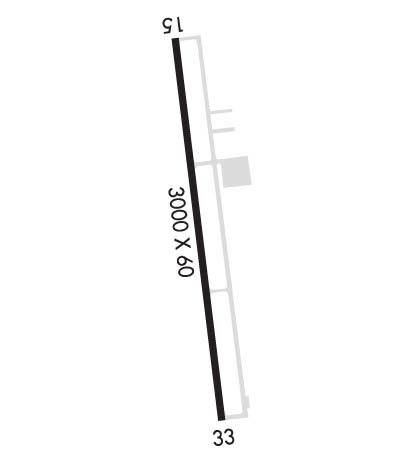
Runway Identifications
Runway Identification: 15/33
Length: 3000 ft
Width: 60 ft
Surface: ASPHALT-GOOD CONDITION
Edge lights: Medium Intensity

Treatment: NONE

 Runway: 15   Runway: 33
Mag heading: 152°Mag heading: 332°
Rwy Slope: -.36% DownRwy Slope: .36% Up
Approach: Approach:
Pattern: Right TrafficPattern: Left Traffic
Markings: BASICMarkings: BASIC
Marking Condition: GOODMarking Condition: GOOD
Arresting Dev: Arresting Dev:
Lat & Long: N4359.2  W12406.8Lat. & Long.: N4358.7  W12406.6
Elev: 50.8 ft. MSLElev: 40.1 ft. MSL
TCH: 45 ft. AGLTCH: 45 ft. AGL
Visual Glide Path: 4.00 degreesVisual Glide Path: 4.00 degrees
Displaced Threshold: NoDisplaced Threshold: No
Touchdown Zone: YESTouchdown Zone: YES
Touchdown Elev.: 50.8 feetTouchdown Elev.: 50.8 feet
Visual Glide Slope: 2-Light PAPI on LEFT side of RunwayVisual Glide Slope: 2-Light PAPI on LEFT side of Runway; UNUSBLE BYD 5 DEGS LEFT OF CNTRLN.
RVR Equipment: RVR Equipment:
RVV Equipment: NORVV Equipment: NO
Approach Lights: Approach Lights:
REIL: YESREIL: YES
Centerline Lights: NOCenterline Lights: NO
Touchdown lights: NOTouchdown lights: NO
Runway Category: Runway with a Visual ApproachRunway Category: Runway with a Visual Approach
Declared Distances: Declared Distances:
Obstructions: HILLObstructions: TREES
Marked: NOT Marked/LightedMarked: NOT Marked/Lighted
Clearance slope: 17:1Clearance slope: 7:1
Obstruction height: 75 feet AGL; RW 33 HAS 15' FENCE CROSSING APPROACH AT 518'.Obstruction height: 63 feet AGL
Dist. from runway: 1517 feetDist. from runway: 695 feet
Centerline offset: 125 left of centerlineCenterline offset: 140B
Comments: Comments:
C:1/P: