Click here for more info on on SMS!

K6S0

BIG TIMBER
BIG TIMBER
MT
Time Zone: Mountain
Lat: N 4548.4
Long: W 10958.7
Elev: 4494
Var: -11
Longest Runway: 5285
AWOS: 132.05
CTAF: 122.8

FBO & Flight Services info for K6S0

FBOs: Update your Fuel Prices

YELLOWSTONE AIRPh: 406-932-4389 Fax: 406-932-5167 Freq: 122.8
Service
Jet
100LL
SAF
MoGas
Fuel Avail: PRIST+$6.80/gal 8-5, M-F/Available 24Hrs Call/Text/Email Ahead-We are happy to accommodate!
Full6.426.75    Last Update: 04/04/2024 14:43

Phillips 66 Branded
Self        
 Address: HWY 298 & AIRPORT RD   BIG TIMBER, MT 59011
AWOSPh: 406-932-6051
-
Freq: 132.05  
If you are an FBO, call 1-203-262-1700 to update your info or email: FltPlan.Advertising@garmin.com
Advertise your FBO on FltPlan.com

Runway & Approach Info for K6S0
Rwy
Length
Land Dist**
Approach*
  Rwy
Length
Land Dist**
Approach*
06
5285x75  5285'          
 
  
24
  5285x75  5285'          
 
18
3475x75  3475'          
 
  
36
  3475x75  3475'          
 
 * only ILS, LOC, LDA, and SDF approaches to a specific runway are shown
** For any Declared Landing Distance Available, please see A/FD or Approach plates
Runway Weight Capability (lbs.) Help
Runway IDSingle WheelDouble WheelDouble Tandem WheelDual Double Wheel
06/2412,000N/AN/AN/A
18/36N/AN/AN/AN/A
These numbers are Advisory and are not limits.   The Airport Manager should have more accurate Weight Limits
Approach Charts
Approaches    
Current Weather/Notams
Customs Information Send updates to Support@FltPlan.com
Customs Not Available
Database effective 05/16/2024
Airport Diagram of K6S0
Airport Diagram might not be current.

Facility Name: BIG TIMBER AT HOWARD FLD
City Name: BIG TIMBER
County: SWEET GRASS
State abbrev: MT
State Name: MONTANA
   
Ownership: PUBLICLY OWNED
Use: OPEN TO THE PUBLIC
Owner's Name: CITY OF BIG TIMBER/SWEETGRASS CO
Address: PO BOX 888
 BIG TIMBER, MT 59011
Owner's Phone: 406-932-5152
  
Manager's Name: ROBERT BRYAN
Address: BOX 279
 BIG TIMBER, MT 59011
Phone: 406-930-1040
   
FAA Region: NORTHWEST MOUNTAIN
FAA Field Office: HLN


Sunrise / Sunset times for BIG TIMBER AT HOWARD FLD

DateSunriseSunset
04/25/24 Thursday6:1520:21
04/26/24 Friday6:1420:22
04/27/24 Saturday6:1220:23
04/28/24 Sunday6:1120:25
04/29/24 Monday6:0920:26
04/30/24 Tuesday6:0820:27
05/01/24 Wednesday6:0620:29
05/02/24 Thursday6:0520:30
05/03/24 Friday6:0320:31
05/04/24 Saturday6:0220:32
05/05/24 Sunday6:0020:34
05/06/24 Monday5:5920:35
05/07/24 Tuesday5:5720:36
05/08/24 Wednesday5:5620:37

Airport Facilities

Airport Attendance ScheduleMON-FRI 0800-1700, SAT-SUN ON CALL; FOR ATTENDANT SAT & SUN CALL 406-932-4389.
Airport Status OPERATIONAL (This Status can change at any time - please check NOTAMS)
Airport Lighting SchedulePAPI RWY 24; MIRL RWY 06/24 OPR DUSK-MIDNIGHT, OTR TIMES ACTVT - CTAF.
Airport Storage AvailableTie Downs
Extra Services AvailableCrop Dusting, Charter
Wind IndicatorYES - (lighted)
Control TowerNO
CTAF Frequency122.800
Unicom Frequency122.800
Rotating Beacon ColorWG
Segmented CircleYES
Landing FeeNO

Airport Inspection Data

Airport InspectedSTATE - performed by STATE AERONAUTICAL PERSONNEL
Inspection Date09/03/2020

Airport Services

Type of Fuel AvailableGrade 100LL, JET A (freeze point -40C); -10100LL & JET A FUEL AVBL UPON REQ. CALL 406-932-4389 OR 406-930-1683.
Airframe Repair ServiceMAJOR
Power Plant Repair ServiceMAJOR

Geographic Data

LatitudeN4548.4
LongitudeW10958.7 (ESTIMATED)
Arpt Elevation4493ft (SURVEYED)
Magnetic Variation11E
3 miles SWof BIG TIMBER
Traffic Pattern Altitude
Sectional ChartGREAT FALLS

Aircraft Data

Operations (Reported)YearlyAvg. Daily
General Aviation Transient 10003
General Aviation Local 20005
Air Taxi 6002
Commerical 00
Commuter 00
Military 00
Aircraft based on Field
General Aviation Singles 17
General Aviation Multi 0
Jet Aircraft 1
General Aviation Helicopters 0
Military Aircraft 0
Gliders 0
Ultralights 0

FAA Services

FSS on field NO
FSS tie-in GREAT FALLS
FSS Phone 1-800-WX-BRIEF
Who issues Notams GTF
Notam D service at airport YES
ARTCC Name SALT LAKE CITY

Federal Status

Airport Certification
Aircraft Rescue & Firefighting IndexNone
Airport of EntryNo
Custom Landing RightsNo
Joint Civil/MilitaryNo
Military Landing rightsYES

Federal Agreements

NATIONAL PLAN OF INTEGRATED AIRPORT SYSTEMS (NPIAS)
GRANT AGREEMENTS UNDER FAAP/ADAP/AIP
ASSURANCES PURSUANT TO TITLE VI, CIVIL RIGHTS ACT OF 1964

Remarks

FOR CD CTC SALT LAKE ARTCC AT 801-320-2568.
Airport Communications & Frequencies:
CTAF Frequency:
122.800
Unicom Frequency:
122.800
Remarks
  • APCH/DEP CTL SVC PRVDD BY SALT LAKE ARTCC (ZLC) ON 127.75/351.9 (BILLINGS RCAG).
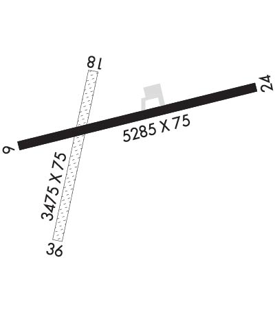
  • Runway Identifications
    Runway Identification: 06/24
    Length: 5285 ft
    Width: 75 ft
    Surface: ASPHALT-GOOD CONDITION
    Edge lights: Medium Intensity

    Treatment: NONE

     Runway: 06   Runway: 24
    Mag heading: 63°Mag heading: 243°
    Rwy Slope: -.61% DownRwy Slope: .61% Up
    Approach: Approach:
    Pattern: Left TrafficPattern: Left Traffic
    Markings: NONPRECISION INSTRUMENTMarkings: NONPRECISION INSTRUMENT
    Marking Condition: GOODMarking Condition: GOOD
    Arresting Dev: Arresting Dev:
    Lat & Long: N4548.3  W10959.2Lat. & Long.: N4548.5  W10958.0
    Elev: 4490.2 ft. MSLElev: 4457.7 ft. MSL
    TCH: TCH: 45 ft. AGL
    Visual Glide Path: Visual Glide Path: 3.00 degrees
    Displaced Threshold: NoDisplaced Threshold: No
    Touchdown Zone: YESTouchdown Zone: YES
    Touchdown Elev.: 4490.2 feetTouchdown Elev.: 4477.4 feet
    Visual Glide Slope: Visual Glide Slope: 2-Light PAPI on LEFT side of Runway
    RVR Equipment: RVR Equipment:
    RVV Equipment: NORVV Equipment: NO
    Approach Lights: Approach Lights:
    REIL: NOREIL: NO
    Centerline Lights: NOCenterline Lights: NO
    Touchdown lights: NOTouchdown lights: NO
    Runway Category: Runway with a Non-precision ApproachRunway Category: Runway with a Non-precision Approach
    Declared Distances: Declared Distances:
    Runway Identification: 18/36
    Length: 3475 ft
    Width: 75 ft
    Surface: GRASS-GOOD CONDITION
    Edge lights:

    Treatment: NONE

     Runway: 18   Runway: 36
    Mag heading: 182°Mag heading:
    Rwy Slope: .68% UpRwy Slope: -.68% Down
    Approach: Approach:
    Pattern: Left TrafficPattern: Left Traffic
    Markings: Markings:
    Marking Condition: 18/36 - THLDS MARKED WITH CONES.Marking Condition:
    Arresting Dev: Arresting Dev:
    Lat & Long: N4548.6  W10958.7Lat. & Long.: N4548.1  W10958.9
    Elev: 4468.8 ft. MSLElev: 4492.4 ft. MSL
    TCH: TCH:
    Visual Glide Path: Visual Glide Path:
    Displaced Threshold: NoDisplaced Threshold: No
    Touchdown Zone: YESTouchdown Zone: YES
    Touchdown Elev.: 4487.5 feetTouchdown Elev.: 4493.9 feet
    Visual Glide Slope: Visual Glide Slope:
    RVR Equipment: RVR Equipment:
    RVV Equipment: NORVV Equipment: NO
    Approach Lights: Approach Lights:
    REIL: NOREIL: NO
    Centerline Lights: NOCenterline Lights: NO
    Touchdown lights: NOTouchdown lights: NO
    Runway Category: Runway with a Visual ApproachRunway Category: Runway with a Visual Approach
    Declared Distances: Declared Distances:
    C:3/P: