
| ||||||||||||||||||||||||||||||||||||||||||||
| ||||||||||||||||||||||||||||||||||||||||||||
| ||||||||||||||||||||||||||||||||||||||||||||
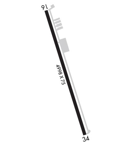
| Rwy | Rwy | |||||||
| 5001x75 | 5001' | 5001x75 | 5001' | |||||
| Runway ID | Single Wheel | Double Wheel | Double Tandem Wheel | Dual Double Wheel |
| 16/34 | 30,000 | N/A | N/A | N/A |
| These numbers are Advisory and are not limits. The Airport Manager should have more accurate Weight Limits | ||||
 Airport Diagram might not be current. | |
| Facility Name: | CLEVELAND MUNI |
| City Name: | CLEVELAND |
| County: | LIBERTY |
| State abbrev: | TX |
| State Name: | TEXAS |
| Ownership: | PUBLICLY OWNED |
| Use: | OPEN TO THE PUBLIC |
| Owner's Name: | CITY OF CLEVELAND |
| Address: | 907 E. HOUSTON ST |
| CLEVELAND, TX 77327 | |
| Owner's Phone: | 281-592-2667 |
| Manager's Name: | DICKIE HARBOUR |
| Address: | 17699 HIGHWAY 787 W. |
| CLEVELAND, TX 77328 | |
| Phone: | 281-592-1282 |
| FAA Region: | SOUTHWEST |
| FAA Field Office: | TEX |
| Date | Sunrise | Sunset |
|---|---|---|
| 04/24/24 Wednesday | 6:43 | 19:54 |
| 04/25/24 Thursday | 6:42 | 19:55 |
| 04/26/24 Friday | 6:41 | 19:55 |
| 04/27/24 Saturday | 6:40 | 19:56 |
| 04/28/24 Sunday | 6:39 | 19:57 |
| 04/29/24 Monday | 6:38 | 19:57 |
| 04/30/24 Tuesday | 6:37 | 19:58 |
| 05/01/24 Wednesday | 6:36 | 19:59 |
| 05/02/24 Thursday | 6:35 | 19:59 |
| 05/03/24 Friday | 6:34 | 20:00 |
| 05/04/24 Saturday | 6:33 | 20:01 |
| 05/05/24 Sunday | 6:33 | 20:01 |
| 05/06/24 Monday | 6:32 | 20:02 |
| 05/07/24 Tuesday | 6:31 | 20:02 |
| Airport Attendance Schedule | M-S 0800-1800, SUN 1300-1800 |
| Airport Status | OPERATIONAL (This Status can change at any time - please check NOTAMS) |
| Airport Lighting Schedule | ACTVT PAPI RWY 16 & 34; MIRL RWY 16/34 - CTAF. |
| Airport Storage Available | Tie Downs |
| Extra Services Available | NONE |
| Wind Indicator | YES - (lighted) |
| Control Tower | NO |
| CTAF Frequency | 123.000 |
| Unicom Frequency | 123.000 |
| Rotating Beacon Color | WG |
| Segmented Circle | YES |
| Landing Fee | NO |
| Airport Inspected | STATE - performed by PRIVATE CONTRACT PERSONNEL |
| Inspection Date | 04/07/2023 |
| Type of Fuel Available | Grade 100LL |
| Airframe Repair Service | MAJOR |
| Power Plant Repair Service | MAJOR |
| Latitude | N3021.4 |
| Longitude | W09500.5 (ESTIMATED) |
| Arpt Elevation | 150ft (SURVEYED) |
| Magnetic Variation | 05E |
| 4 miles NE | of CLEVELAND |
| Traffic Pattern Altitude | |
| Sectional Chart | HOUSTON |
| Operations (Reported) | Yearly | Avg. Daily |
|---|---|---|
| General Aviation Transient | 7580 | 21 |
| General Aviation Local | 15800 | 43 |
| Air Taxi | 10 | 0 |
| Commerical | 0 | 0 |
| Commuter | 0 | 0 |
| Military | 500 | 1 |
| Aircraft based on Field | |
|---|---|
| General Aviation Singles | 16 |
| General Aviation Multi | 2 |
| Jet Aircraft | 0 |
| General Aviation Helicopters | 0 |
| Military Aircraft | 0 |
| Gliders | 0 |
| Ultralights | 0 |
| FSS on field | NO |
| FSS tie-in | MONTGOMERY COUNTY |
| FSS Phone | 1-800-WX-BRIEF |
| Who issues Notams | CXO |
| Notam D service at airport | YES |
| ARTCC Name | HOUSTON |
| Airport Certification | |
| Aircraft Rescue & Firefighting Index | None |
| Airport of Entry | No |
| Custom Landing Rights | No |
| Joint Civil/Military | No |
| Military Landing rights | YES |
| NATIONAL PLAN OF INTEGRATED AIRPORT SYSTEMS (NPIAS) |
| GRANT AGREEMENTS UNDER FAAP/ADAP/AIP |
| ASSURANCES PURSUANT TO TITLE VI, CIVIL RIGHTS ACT OF 1964 |
| THIS AIRPORT HAS BEEN SURVEYED BY THE NATIONAL GEODETIC SURVEY. |
| TO ACCESS AIRPORT SECURITY GATE USE UNICOM FREQUENCY. |
| +25 FT TREES 260 FT WEST OF CNTRLN AT THR. |
| FOR SVC AFT HRS CALL 281-761-5012. |
| FOR CD CTC HOUSTON APCH AT 281-443-5844 TO CNL IFR CALL 281-443-5888. |
| RWY 16 CALM WIND RWY. |
Airport Communications & Frequencies:
| ||||||||||||||
| Runway: 16 | Runway: 34 | ||
| Mag heading: | 157° | Mag heading: | 337° |
| Rwy Slope: | -.17% Down | Rwy Slope: | .17% Up |
| Approach: | Approach: | ||
| Pattern: | Left Traffic | Pattern: | Left Traffic |
| Markings: | NONPRECISION INSTRUMENT | Markings: | NONPRECISION INSTRUMENT |
| Marking Condition: | GOOD | Marking Condition: | GOOD |
| Arresting Dev: | Arresting Dev: | ||
| Lat & Long: | N3021.8 W09500.6 | Lat. & Long.: | N3021.0 W09500.3 |
| Elev: | 150.0 ft. MSL | Elev: | 141.5 ft. MSL |
| TCH: | 52 ft. AGL | TCH: | 45 ft. AGL |
| Visual Glide Path: | 3.00 degrees | Visual Glide Path: | 3.00 degrees |
| Displaced Threshold: | No | Displaced Threshold: | No |
| Touchdown Zone: | YES | Touchdown Zone: | YES |
| Touchdown Elev.: | 150.0 feet | Touchdown Elev.: | 146.6 feet |
| Visual Glide Slope: | 4-Light PAPI on LEFT side of Runway | Visual Glide Slope: | 4-Light PAPI on LEFT side of Runway |
| RVR Equipment: | RVR Equipment: | ||
| RVV Equipment: | NO | RVV Equipment: | NO |
| Approach Lights: | Approach Lights: | ||
| REIL: | NO | REIL: | NO |
| Centerline Lights: | NO | Centerline Lights: | NO |
| Touchdown lights: | NO | Touchdown lights: | NO |
| Runway Category: | Runway with a Non-precision Approach having visibility minimums greater than 3/4 mile | Runway Category: | Runway with a Visual Approach |
| Declared Distances: | Declared Distances: | ||
| Obstructions: | TREES | Obstructions: | TREES |
| Marked: | NOT Marked/Lighted | Marked: | NOT Marked/Lighted |
| Clearance slope: | Clearance slope: | 15:1 | |
| Obstruction height: | 32 feet AGL | Obstruction height: | 72 feet AGL |
| Dist. from runway: | 201 feet | Dist. from runway: | 1300 feet |
| Centerline offset: | 240 right of centerline | Centerline offset: | |
| Comments: | 32 FT TREES 0-199 FT DSTC,- 240 FT RIGHT. | Comments: |
