Click here for more info on on SMS!

K6P3

WAUNAKEE
WAUNAKEE
WI
Time Zone: Central
Lat: N 4310.7
Long: W 08927.1
Elev: 954
Var: -00
Longest Runway: 2223
CTAF: 122.9

FBO & Flight Services info for K6P3

FBOs: Update your Fuel Prices

AIRPORTPh: 608-849-4318
-
Freq: 122.9
Service
Jet
100LL
SAF
MoGas
Fuel Avail: ~~100LL & MOGAS AVAILABLE FOR FUEL CALL 608-225-1109.
Full        Last Update: 04/24/2024 06:02:17

Self        
If you are an FBO, call 1-203-262-1700 to update your info or email: FltPlan.Advertising@garmin.com
Advertise your FBO on FltPlan.com

Runway & Approach Info for K6P3
Rwy
Length
Land Dist**
Approach*
  Rwy
Length
Land Dist**
Approach*
09
2223x30  2223'          
 
  
27
  2223x30  1970'          
 
 * only ILS, LOC, LDA, and SDF approaches to a specific runway are shown
** For any Declared Landing Distance Available, please see A/FD or Approach plates
Runway Weight Capability (lbs.) Help
Runway IDSingle WheelDouble WheelDouble Tandem WheelDual Double Wheel
09/27N/AN/AN/AN/A
These numbers are Advisory and are not limits.   The Airport Manager should have more accurate Weight Limits
Approach Charts
FltPlan does not have IFR approach charts available for K6P3.
Current Weather/Notams
Customs Information Send updates to Support@FltPlan.com
Customs Not Available
Database effective 05/16/2024
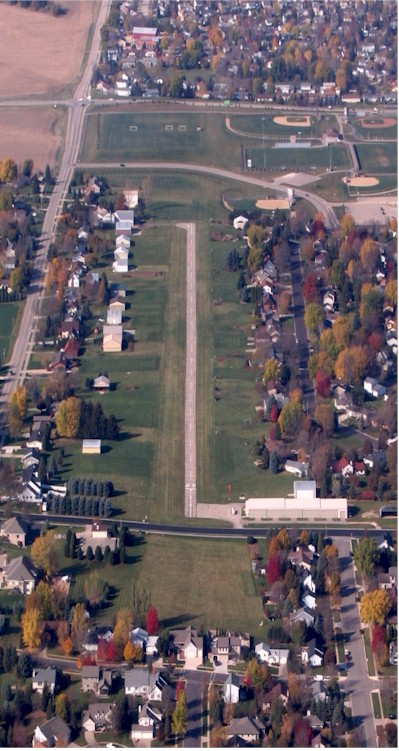
Facility Name: WAUNAKEE
City Name: WAUNAKEE
County: DANE
State abbrev: WI
State Name: WISCONSIN
   
Ownership: PRIVATELY OWNED
Use: OPEN TO THE PUBLIC
Owner's Name: WAUNAKEE AIRPARK LLC
Address: 5992 WOODLAND DR
 WAUNAKEE, WI 53597
Owner's Phone: 608-698-9498
  
Manager's Name: JAMES MEIER & JOE ANDROFSKI
Address: 1103 WINSTON CIRCLE
 WAUNAKEE, WI 53597
Phone: 608-225-1109
   
FAA Region: GREAT LAKES
FAA Field Office: CHI


Sunrise / Sunset times for WAUNAKEE

DateSunriseSunset
04/23/24 Tuesday6:0219:51
04/24/24 Wednesday6:0019:52
04/25/24 Thursday5:5919:53
04/26/24 Friday5:5719:54
04/27/24 Saturday5:5619:56
04/28/24 Sunday5:5419:57
04/29/24 Monday5:5319:58
04/30/24 Tuesday5:5219:59
05/01/24 Wednesday5:5020:00
05/02/24 Thursday5:4920:01
05/03/24 Friday5:4720:02
05/04/24 Saturday5:4620:04
05/05/24 Sunday5:4520:05
05/06/24 Monday5:4420:06

Airport Facilities

Airport Attendance ScheduleUNATTENDED
Airport Status OPERATIONAL (This Status can change at any time - please check NOTAMS)
Airport Lighting ScheduleACTVT LIRL RWY 09/27 - CTAF.
Airport Storage AvailableTie Downs
Extra Services AvailableNONE
Wind IndicatorYES - (lighted)
Control TowerNO
CTAF Frequency122.900
Unicom Frequency
Rotating Beacon Color
Segmented CircleNO
Landing FeeNO

Airport Inspection Data

Airport InspectedSTATE - performed by STATE AERONAUTICAL PERSONNEL
Inspection Date06/11/2021

Airport Services

Type of Fuel AvailableGrade 100LLUL94
Airframe Repair ServiceNONE
Power Plant Repair ServiceNONE

Geographic Data

LatitudeN4310.7
LongitudeW08927.1 (ESTIMATED)
Arpt Elevation954ft (ESTIMATED)
Magnetic Variation00E
1 miles Sof WAUNAKEE
Traffic Pattern Altitude
Sectional ChartCHICAGO

Aircraft Data

Operations (Reported)YearlyAvg. Daily
General Aviation Transient 20005
General Aviation Local 20005
Air Taxi 00
Commerical 00
Commuter 00
Military 00
Aircraft based on Field
General Aviation Singles 35
General Aviation Multi 0
Jet Aircraft 0
General Aviation Helicopters 0
Military Aircraft 0
Gliders 0
Ultralights 0

FAA Services

FSS on field NO
FSS tie-in GREEN BAY
FSS Phone 1-800-WX-BRIEF
Who issues Notams GRB
Notam D service at airport YES
ARTCC Name CHICAGO

Federal Status

Airport Certification
Aircraft Rescue & Firefighting IndexNone
Airport of EntryNo
Custom Landing RightsNo
Joint Civil/MilitaryNo
Military Landing rightsNo

Remarks

FOR CD CTC MADISON APP/DEP CON AT 608-249-8240. WHEN MADISON APCH CLSD, FOR CD CTC CHICAGO ARTCC AT 630-906-8921.
RWY 09/2 7 NSTD LIRL 165 FT FM E END; 155 FT FM W END; 1910 FT OF RY IS LGTD. RY LGTS APROXLY 60 FT FM PAVEMENT EDGE.
Runway Identifications
Runway Identification: 09/27
Length: 2223 ft
Width: 30 ft
Surface: ASPHALT-FAIR CONDITION
Edge lights: Non-Standard Lighting System

Treatment: NONE

 Runway: 09   Runway: 27
Mag heading: 90°Mag heading: 270°
Rwy Slope: -.98% DownRwy Slope: .98% Up
Approach: Approach:
Pattern: Left TrafficPattern: Left Traffic
Markings: BASICMarkings: BASIC
Marking Condition: FAIRMarking Condition: FAIR
Arresting Dev: Arresting Dev:
Lat & Long: N4310.7  W08927.3Lat. & Long.: N4310.7  W08926.8
Elev: 954.4 ft. MSLElev: 932.7 ft. MSL
TCH: TCH:
Visual Glide Path: Visual Glide Path:
Displaced Threshold: NoDisplaced Threshold: 253 feet; NSTD DSPLCD THR MKGS.
Touchdown Zone: YESTouchdown Zone: YES
Touchdown Elev.: 954.4 feetTouchdown Elev.: 954.4 feet
Visual Glide Slope: Visual Glide Slope:
RVR Equipment: RVR Equipment:
RVV Equipment: NORVV Equipment: NO
Approach Lights: Approach Lights:
REIL: NOREIL: NO
Centerline Lights: NOCenterline Lights: NO
Touchdown lights: NOTouchdown lights: NO
Runway Category: Runway with a Visual ApproachRunway Category: Runway with a Visual Approach
Declared Distances: Declared Distances:
Obstructions: Obstructions: TREES
Marked: Marked: NOT Marked/Lighted
Clearance slope: 20:1Clearance slope: 8:1; APCH RATIO 20:1 TO DSPLCD THLD.
Obstruction height: Obstruction height: 44 feet AGL
Dist. from runway: Dist. from runway: 553 feet
Centerline offset: Centerline offset: 75 feet left of centerline
Comments: +65 FT TREE 100 FT FRM THR 150 FT R OF CL.Comments: ROAD 50 FT FM THR L&R OF CL; +9 FT SIGN 90 FT FM THR 100 FT L OF CL.
C:/P: