Current Weather/Notams (Metars, TAFs, Notams, NWS Forecast, PIREPS, and nearby weather)
Customs Information Send updates to Support@FltPlan.com
Customs Not Available
Database effective 05/16/2024
Airport Diagram might not be current.
|
| Facility Name: | HORSESHOE BEND |
| City Name: | HORSESHOE BEND |
| County: | IZARD |
| State abbrev: | AR |
| State Name: | ARKANSAS |
| | |
| Ownership: | PUBLICLY OWNED |
| Use: | OPEN TO THE PUBLIC |
| Owner's Name: | CITY OF HORSEHOE BEND |
| Address: | CITY HALL - 704 W COMMERCE |
| | HORSESHOE BEND, AR 72512 |
| Owner's Phone: | 870-670-5113 |
| | |
| Manager's Name: | ERIC SECRETAN |
| Address: | 704 W COMMERCE |
| | HORSESHOE BEND, AR 72512 |
| Phone: | 304-268-3666 |
| | |
| FAA Region: | SOUTHWEST |
| FAA Field Office: | AOK |
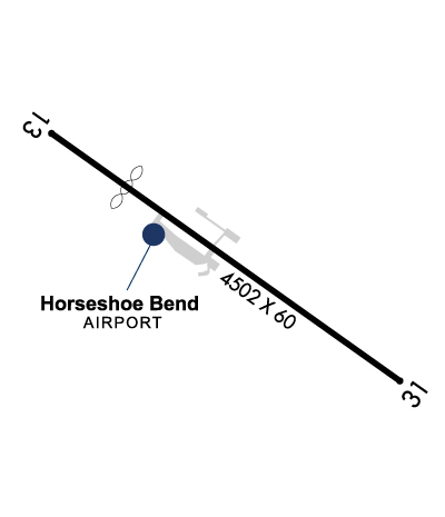
Runway Identifications
Runway Identification: 13/31Length: 4502 ft
Width: 60 ft
Surface: ASPHALT-FAIR CONDITION
Edge lights: Medium IntensityTreatment: NONE
| | Runway: 13 | | Runway: 31 |
| Mag heading: | 125° | Mag heading: | 305° |
| Rwy Slope: | -.10% Down | Rwy Slope: | .10% Up |
| Approach: | | Approach: | |
| Pattern: | Left Traffic | Pattern: | Left Traffic |
| Markings: | BASIC | Markings: | NONPRECISION INSTRUMENT |
| Marking Condition: | GOOD | Marking Condition: | GOOD |
| Arresting Dev: | | Arresting Dev: | |
| Lat & Long: | N3613.5 W09145.7 | Lat. & Long.: | N3613.1 W09145.0 |
| Elev: | 781.8 ft. MSL | Elev: | 777.4 ft. MSL |
| TCH: | | TCH: | 40 ft. AGL |
| Visual Glide Path: | | Visual Glide Path: | 3.00 degrees |
| Displaced Threshold: | 994 feet | Displaced Threshold: | No |
| Touchdown Zone: | YES | Touchdown Zone: | YES |
| Touchdown Elev.: | 781.2 feet | Touchdown Elev.: | 781.2 feet |
| Visual Glide Slope: | | Visual Glide Slope: | 2-Light PAPI on LEFT side of Runway |
| RVR Equipment: | | RVR Equipment: | |
| RVV Equipment: | NO | RVV Equipment: | NO |
| Approach Lights: | | Approach Lights: | |
| REIL: | NO | REIL: | NO |
| Centerline Lights: | NO | Centerline Lights: | NO |
| Touchdown lights: | NO | Touchdown lights: | NO |
| Runway Category: | Runway with a Visual Approach | Runway Category: | Runway with a Non-precision Approach |
| Declared Distances: | | Declared Distances: | |
| Obstructions: | TREES | Obstructions: | TREE |
| Marked: | NOT Marked/Lighted | Marked: | NOT Marked/Lighted |
| Clearance slope: | 9:1 | Clearance slope: | 6:1 |
| Obstruction height: | 110 feet AGL | Obstruction height: | 32 feet AGL |
| Dist. from runway: | 1200 feet | Dist. from runway: | 400 feet |
| Centerline offset: | | Centerline offset: | 225 feet right of centerline |
| Comments: | RAPIDLY RISING TRRN WITH TREES FNA RWY 13. TRRN RISES 681 FT BTN 200-1100 FT FM RWY END. | Comments: | |