Approach Charts
| FltPlan does not have IFR approach charts available for K6L5. |
Current Weather/Notams (Metars, TAFs, Notams, NWS Forecast, PIREPS, and nearby weather)
Customs Information Send updates to Support@FltPlan.com
Customs Not Available
Database effective 05/16/2024
Airport Diagram might not be current.
|
| Facility Name: | WISHEK MUNI |
| City Name: | WISHEK |
| County: | MC INTOSH |
| State abbrev: | ND |
| State Name: | NORTH DAKOTA |
| | |
| Ownership: | PUBLICLY OWNED |
| Use: | OPEN TO THE PUBLIC |
| Owner's Name: | CITY OF WISHEK; ARPT AUTH OPERATES ARPT. |
| Address: | BOX 62 |
| | WISHEK, ND 58495 |
| Owner's Phone: | 701-452-2314; LORREN HENKE - CHAIRPERSON: ADDL PHONE 701-321-2348 |
| | |
| Manager's Name: | NATHAN WOLF |
| Address: | 8830 33RD AVE SE |
| | WISHEK, ND 58495 |
| Phone: | 701-321-2703 |
| | |
| FAA Region: | GREAT LAKES |
| FAA Field Office: | DMA |
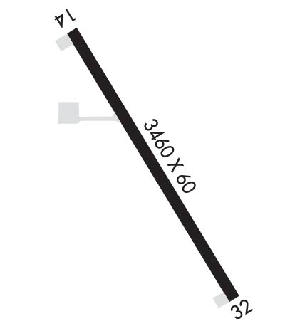
Runway Identifications
Runway Identification: 14/32Length: 3460 ft
Width: 60 ft
Surface: ASPHALT-FAIR CONDITION
Edge lights: Low IntensityTreatment: NONE
| | Runway: 14 | | Runway: 32 |
| Mag heading: | 138° | Mag heading: | 318° |
| Rwy Slope: | .05% Up | Rwy Slope: | -.05% Down |
| Approach: | | Approach: | |
| Pattern: | Left Traffic | Pattern: | Left Traffic |
| Markings: | BASIC | Markings: | BASIC |
| Marking Condition: | FAIR | Marking Condition: | FAIR |
| Arresting Dev: | | Arresting Dev: | |
| Lat & Long: | N4615.2 W09932.6 | Lat. & Long.: | N4614.7 W09932.2 |
| Elev: | 2040.7 ft. MSL | Elev: | 2042.4 ft. MSL |
| TCH: | | TCH: | |
| Visual Glide Path: | | Visual Glide Path: | |
| Displaced Threshold: | No | Displaced Threshold: | No |
| Touchdown Zone: | NO | Touchdown Zone: | NO |
| Touchdown Elev.: | | Touchdown Elev.: | |
| Visual Glide Slope: | | Visual Glide Slope: | |
| RVR Equipment: | | RVR Equipment: | |
| RVV Equipment: | NO | RVV Equipment: | NO |
| Approach Lights: | | Approach Lights: | |
| REIL: | NO | REIL: | NO |
| Centerline Lights: | NO | Centerline Lights: | NO |
| Touchdown lights: | NO | Touchdown lights: | NO |
| Runway Category: | Runway with a Visual Approach | Runway Category: | Runway with a Visual Approach |
| Declared Distances: | | Declared Distances: | |
| Obstructions: | ROAD | Obstructions: | ROAD |
| Marked: | NOT Marked/Lighted | Marked: | NOT Marked/Lighted |
| Clearance slope: | 20:1 | Clearance slope: | 17:1 |
| Obstruction height: | 15 feet AGL | Obstruction height: | 10 feet AGL |
| Dist. from runway: | 500 feet | Dist. from runway: | 370 feet |
| Centerline offset: | 150 right of centerline | Centerline offset: | 140 feet left of centerline |
| Comments: | | Comments: | |

