| |||||||||||||||||||||||||||||||||||||||||||||||||||||||||||||
| |||||||||||||||||||||||||||||||||||||||||||||||||||||||||||||
| |||||||||||||||||||||||||||||||||||||||||||||||||||||||||||||
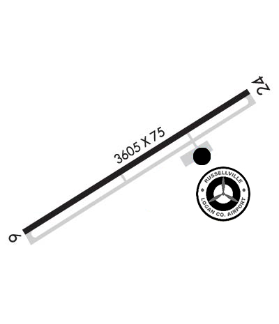
| Rwy | Rwy | |||||||
| 3605x75 | 3605' | 3605x75 | 3605' | |||||
| Runway ID | Single Wheel | Double Wheel | Double Tandem Wheel | Dual Double Wheel |
| 06/24 | N/A | N/A | N/A | N/A |
| These numbers are Advisory and are not limits. The Airport Manager should have more accurate Weight Limits | ||||
 Airport Diagram might not be current. | |
| Facility Name: | LOGAN COUNTY |
| City Name: | LOGAN |
| County: | LOGAN |
| State abbrev: | WV |
| State Name: | WEST VIRGINIA |
| Ownership: | PUBLICLY OWNED |
| Use: | OPEN TO THE PUBLIC |
| Owner's Name: | LOGAN COUNTY ARPT AUTH |
| Address: | PO BOX 1973 |
| LOGAN, WV 25601 | |
| Owner's Phone: | 304-752-0975 |
| Manager's Name: | MEGAN R JOHNSON |
| Address: | P O BOX 1793 |
| LOGAN, WV 25601 | |
| Phone: | 304-752-0975 |
| FAA Region: | EASTERN |
| FAA Field Office: | BKW |
| Date | Sunrise | Sunset |
|---|---|---|
| 04/24/24 Wednesday | 6:39 | 20:13 |
| 04/25/24 Thursday | 6:38 | 20:13 |
| 04/26/24 Friday | 6:37 | 20:14 |
| 04/27/24 Saturday | 6:36 | 20:15 |
| 04/28/24 Sunday | 6:34 | 20:16 |
| 04/29/24 Monday | 6:33 | 20:17 |
| 04/30/24 Tuesday | 6:32 | 20:18 |
| 05/01/24 Wednesday | 6:31 | 20:19 |
| 05/02/24 Thursday | 6:30 | 20:20 |
| 05/03/24 Friday | 6:29 | 20:21 |
| 05/04/24 Saturday | 6:28 | 20:22 |
| 05/05/24 Sunday | 6:26 | 20:23 |
| 05/06/24 Monday | 6:25 | 20:24 |
| 05/07/24 Tuesday | 6:24 | 20:24 |
| Airport Attendance Schedule | 7 Days A Week 0900-1700 |
| Airport Status | OPERATIONAL (This Status can change at any time - please check NOTAMS) |
| Airport Lighting Schedule | ACTVT REIL RWY 06 & 24; PAPI RWY 06 & 24; MIRL RWY 06/24 - CTAF. |
| Airport Storage Available | Tie Downs, Hanger |
| Extra Services Available | Air Ambulance, Avionics, Flight Instruction |
| Wind Indicator | YES - (lighted) |
| Control Tower | NO |
| CTAF Frequency | 122.900 |
| Unicom Frequency | |
| Rotating Beacon Color | WG |
| Segmented Circle | YES |
| Landing Fee |
| Airport Inspected | STATE - performed by STATE AERONAUTICAL PERSONNEL |
| Inspection Date | 07/10/2023 |
| Type of Fuel Available | Grade 100LL, JET A (freeze point -40C); -1024 HR SELF-SVC. |
| Airframe Repair Service | MAJOR; FOR ACFT MAINT SVCS CALL 304-752-0094 DAYS, 304-946-4415 NIGHTS. |
| Power Plant Repair Service | MAJOR |
| Latitude | N3751.3 |
| Longitude | W08155.0 (ESTIMATED) |
| Arpt Elevation | 1666ft (SURVEYED) |
| Magnetic Variation | 07W |
| 4 miles E | of LOGAN |
| Traffic Pattern Altitude | |
| Sectional Chart | CINCINNATI |
| Operations (Reported) | Yearly | Avg. Daily |
|---|---|---|
| General Aviation Transient | 2500 | 7 |
| General Aviation Local | 3500 | 10 |
| Air Taxi | 0 | 0 |
| Commerical | 0 | 0 |
| Commuter | 0 | 0 |
| Military | 300 | 1 |
| Aircraft based on Field | |
|---|---|
| General Aviation Singles | 6 |
| General Aviation Multi | 2 |
| Jet Aircraft | 1 |
| General Aviation Helicopters | 5 |
| Military Aircraft | 0 |
| Gliders | 0 |
| Ultralights | 0 |
| FSS on field | NO |
| FSS tie-in | ELKINS |
| FSS Phone | 1-800-WX-BRIEF |
| Who issues Notams | EKN |
| Notam D service at airport | YES |
| ARTCC Name | INDIANAPOLIS |
| Airport Certification | |
| Aircraft Rescue & Firefighting Index | None |
| Airport of Entry | No |
| Custom Landing Rights | No |
| Joint Civil/Military | No |
| Military Landing rights | No |
| NATIONAL PLAN OF INTEGRATED AIRPORT SYSTEMS (NPIAS) |
| RWY 06, 30 FT HILL 800 FT FROM THLD LEFT. |
| LOW LVL C-130 MIL OPNS IN VCNTY. CK NOTAMS. |
| DEER AND WILDLIFE ON & INVOF ARPT. |
| AIRPORT ACCESS CODE- CTAF. |
| FOR CD CTC CHARLESTON APCH AT 304-344-5867 EXT 281. |
| MILITARY PRACTICE RWY 1.2 MILES NE OF RWY 24 END. NOT CHARTED. |
Airport Communications & Frequencies:
| |||||||||||||||
| Runway: 06 | Runway: 24 | ||
| Mag heading: | 65° | Mag heading: | 245° |
| Rwy Slope: | .34% Up | Rwy Slope: | -.34% Down |
| Approach: | Approach: | ||
| Pattern: | Left Traffic | Pattern: | Left Traffic |
| Markings: | NONPRECISION INSTRUMENT | Markings: | NONPRECISION INSTRUMENT |
| Marking Condition: | FAIR | Marking Condition: | FAIR |
| Arresting Dev: | Arresting Dev: | ||
| Lat & Long: | N3751.2 W08155.3 | Lat. & Long.: | N3751.5 W08154.6 |
| Elev: | 1654.1 ft. MSL | Elev: | 1666.4 ft. MSL |
| TCH: | 47 ft. AGL | TCH: | 42 ft. AGL |
| Visual Glide Path: | 3.00 degrees | Visual Glide Path: | 3.00 degrees |
| Displaced Threshold: | No | Displaced Threshold: | No |
| Touchdown Zone: | YES | Touchdown Zone: | YES |
| Touchdown Elev.: | 1664.7 feet | Touchdown Elev.: | 1666.4 feet |
| Visual Glide Slope: | 2-Light PAPI on LEFT side of Runway | Visual Glide Slope: | 2-Light PAPI on LEFT side of Runway |
| RVR Equipment: | RVR Equipment: | ||
| RVV Equipment: | NO | RVV Equipment: | NO |
| Approach Lights: | Approach Lights: | ||
| REIL: | YES | REIL: | YES |
| Centerline Lights: | NO | Centerline Lights: | NO |
| Touchdown lights: | NO | Touchdown lights: | NO |
| Runway Category: | Runway with a Non-precision Approach | Runway Category: | Runway with a Non-precision Approach |
| Declared Distances: | Declared Distances: | ||
| Obstructions: | TREES | Obstructions: | TREES |
| Marked: | NOT Marked/Lighted | Marked: | NOT Marked/Lighted |
| Clearance slope: | 10:1 | Clearance slope: | 13:1 |
| Obstruction height: | 77 feet AGL | Obstruction height: | 10 feet AGL |
| Dist. from runway: | 1000 feet | Dist. from runway: | 337 feet |
| Centerline offset: | 97 right of centerline | Centerline offset: | 337B |
| Comments: | Comments: |