Click here for more info on on SMS!

K6K5

SISTERS EAGLE AIR
SISTERS
OR
Time Zone: Pacific
Lat: N 4418.3
Long: W 12132.3
Elev: 3168
Var: -19
Longest Runway: 3560
CTAF: 122.9

FBO & Flight Services info for K6K5

FBOs: Update your Fuel Prices
Providing high quality fuel and services to you and your customers from Phillips 66 Aviation.
Ph: 541-719-0602
-
-
WebsiteE-Mail
Service
Jet
100LL
SAF
MoGas
Full        Caution: Fuel prices have not been updated in 31 days.
Last Update: 03/19/2024 14:08

Self  5.80    
Misc. Info: Address: 15820 BARCLAY DRIVE   SISTERS OR 97759

If you are an FBO, call 1-203-262-1700 to update your info or email: FltPlan.Advertising@garmin.com
Advertise your FBO on FltPlan.com

Runway & Approach Info for K6K5
Rwy
Length
Land Dist**
Approach*
  Rwy
Length
Land Dist**
Approach*
02
3560x60  3220'          
 
  
20
  3560x60  3560'          
 
 * only ILS, LOC, LDA, and SDF approaches to a specific runway are shown
** For any Declared Landing Distance Available, please see A/FD or Approach plates
Runway Weight Capability (lbs.) Help
Runway IDSingle WheelDouble WheelDouble Tandem WheelDual Double Wheel
02/204,000N/AN/AN/A
These numbers are Advisory and are not limits.   The Airport Manager should have more accurate Weight Limits
Approach Charts
FltPlan does not have IFR approach charts available for K6K5.
Current Weather/Notams
Customs Information Send updates to Support@FltPlan.com
Customs Not Available
Database effective 04/18/2024
Airport Diagram of K6K5
Airport Diagram might not be current.

Facility Name: SISTERS EAGLE AIR
City Name: SISTERS
County: DESCHUTES
State abbrev: OR
State Name: OREGON
   
Ownership: PRIVATELY OWNED
Use: OPEN TO THE PUBLIC
Owner's Name: SISTERS EAGLE AIR, INC.
Address: PO BOX 507
 SISTERS, OR 97759
Owner's Phone: 541-549-6011
  
Manager's Name: DAVID CAMPBELL
Address: 15820 BARCLAY DR
 SISTERS, OR 97759
Phone: (541) 719-0602
   
FAA Region: NORTHWEST MOUNTAIN
FAA Field Office: SEA


Sunrise / Sunset times for SISTERS EAGLE AIR

DateSunriseSunset
04/18/24 Thursday6:1619:55
04/19/24 Friday6:1419:57
04/20/24 Saturday6:1319:58
04/21/24 Sunday6:1119:59
04/22/24 Monday6:0920:00
04/23/24 Tuesday6:0820:01
04/24/24 Wednesday6:0620:03
04/25/24 Thursday6:0520:04
04/26/24 Friday6:0320:05
04/27/24 Saturday6:0220:06
04/28/24 Sunday6:0020:08
04/29/24 Monday5:5920:09
04/30/24 Tuesday5:5720:10
05/01/24 Wednesday5:5620:11

Airport Facilities

Airport Attendance ScheduleUNATTENDED
Airport Status OPERATIONAL (This Status can change at any time - please check NOTAMS)
Airport Lighting Schedule
Airport Storage AvailableTie Downs
Extra Services AvailableNONE
Wind IndicatorYES - (unlit)
Control TowerNO
CTAF Frequency122.900
Unicom Frequency
Rotating Beacon Color
Segmented CircleNO
Landing FeeNO

Airport Inspection Data

Airport InspectedSTATE - performed by STATE AERONAUTICAL PERSONNEL
Inspection Date08/18/2022

Airport Services

Type of Fuel AvailableGrade 100LL
Airframe Repair ServiceNONE
Power Plant Repair ServiceNONE

Geographic Data

LatitudeN4418.3
LongitudeW12132.3 (ESTIMATED)
Arpt Elevation3168ft (ESTIMATED)
Magnetic Variation19E
1 miles Nof SISTERS
Traffic Pattern Altitude
Sectional ChartKLAMATH FALLS

Aircraft Data

Operations (Reported)YearlyAvg. Daily
General Aviation Transient 9002
General Aviation Local 4001
Air Taxi 1000
Commerical 00
Commuter 00
Military 00
Aircraft based on Field
General Aviation Singles 15
General Aviation Multi 2
Jet Aircraft 0
General Aviation Helicopters 0
Military Aircraft 0
Gliders 0
Ultralights 0

FAA Services

FSS on field NO
FSS tie-in MC MINNVILLE
FSS Phone 1-800-WX-BRIEF
Who issues Notams MMV
Notam D service at airport YES
ARTCC Name SEATTLE

Federal Status

Airport Certification
Aircraft Rescue & Firefighting IndexNone
Airport of EntryNo
Custom Landing RightsNo
Joint Civil/MilitaryNo
Military Landing rightsNo

Remarks

RISING TERRAIN OFF DEP END OF RY 02. CHECK DENSITY ALT/ACFT PERFORMANCE PRIOR TO TKOF. AVOID OVERFLIGHTS OF HOMES TO NE.
DEER ON & INVOF ARPT.
FOR CD CTC SEATTLE ARTCC AT 253-351-3694.
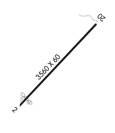
Runway Identifications
Runway Identification: 02/20
Length: 3560 ft
Width: 60 ft
Surface: ASPHALT
Edge lights:

Treatment: NONE

 Runway: 02   Runway: 20
Mag heading: N/AMag heading: N/A
Approach: Approach:
Pattern: Left TrafficPattern: Left Traffic
Markings: NONSTANDARDMarkings: NONSTANDARD
Marking Condition: GOOD; RWY HAS W & YELLOW SIDESTRIPES & MARKINGS.Marking Condition: GOOD
Arresting Dev: Arresting Dev:
Lat & Long: N4418.0  W12132.6Lat. & Long.: N4418.5  W12132.1
Elev: N/AElev: N/A
TCH: TCH:
Visual Glide Path: Visual Glide Path:
Displaced Threshold: 340 feetDisplaced Threshold: No
Touchdown Zone: NOTouchdown Zone: NO
Touchdown Elev.: Touchdown Elev.:
Visual Glide Slope: Visual Glide Slope:
RVR Equipment: RVR Equipment:
RVV Equipment: NORVV Equipment: NO
Approach Lights: Approach Lights:
REIL: NOREIL: NO
Centerline Lights: NOCenterline Lights: NO
Touchdown lights: NOTouchdown lights: NO
Runway Category: Runway with a Visual ApproachRunway Category: Runway with a Visual Approach
Declared Distances: Declared Distances:
Obstructions: TREEObstructions: TREES
Marked: NOT Marked/LightedMarked: NOT Marked/Lighted
Clearance slope: SLP IS 12:1 TO DTHR.Clearance slope: 4:1
Obstruction height: 16 feet AGLObstruction height: 85 feet AGL
Dist. from runway: 201 feetDist. from runway: 560 feet
Centerline offset: 125 right of centerlineCenterline offset: 100 feet left of centerline
Comments: RWY 02 +15 FT ROAD 200' FROM THRSHLD; 4' FENCE AT 1' FROM RWY END AND 100' L OF CNTRLN; 16' ROAD AT 1' FROM RWY END AND 125' L OF CNTRLN.Comments: 5' FENCE AT 201' FROM RUNWAY END AND 100'L OF CENTERLINE
C:/P: