Current Weather/Notams (Metars, TAFs, Notams, NWS Forecast, PIREPS, and nearby weather)
Customs Information Send updates to Support@FltPlan.com
Customs Not Available
Database effective 05/16/2024
Airport Diagram might not be current.
|
| Facility Name: | CREIGHTON MUNI |
| City Name: | CREIGHTON |
| County: | KNOX |
| State abbrev: | NE |
| State Name: | NEBRASKA |
| | |
| Ownership: | PUBLICLY OWNED |
| Use: | OPEN TO THE PUBLIC |
| Owner's Name: | CREIGHTON AIRPORT AUTHORITY |
| Address: | PO BOX 188 |
| | CREIGHTON, NE 68729-0188 |
| Owner's Phone: | (402) 358-3557 |
| | |
| Manager's Name: | ROBERT BORGMANN; BOB BORGMANN, SECRETARY, CREIGHTON AIRPORT AUTHORITY. |
| Address: | P.O. BOX 51 |
| | CREIGHTON, NE 68729-0051 |
| Phone: | (402) 360-2916; MANAGER HOME PHONE 402-358-3343. |
| | |
| FAA Region: | CENTRAL |
| FAA Field Office: | NONE |
Runway Identifications
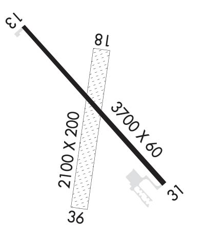
Runway Identification: 13/31Length: 3700 ft
Width: 60 ft
Surface: CONCRETE
Edge lights: Medium IntensityTreatment: NONE
| | Runway: 13 | | Runway: 31 |
| Mag heading: | 125° | Mag heading: | 305° |
| Rwy Slope: | .06% Up | Rwy Slope: | -.06% Down |
| Approach: | | Approach: | |
| Pattern: | Left Traffic | Pattern: | Left Traffic |
| Markings: | NONPRECISION INSTRUMENT | Markings: | NONPRECISION INSTRUMENT |
| Marking Condition: | GOOD | Marking Condition: | GOOD |
| Arresting Dev: | | Arresting Dev: | |
| Lat & Long: | N4228.5 W09753.4 | Lat. & Long.: | N4228.1 W09752.8 |
| Elev: | 1641.8 ft. MSL | Elev: | 1644.0 ft. MSL |
| TCH: | 40 ft. AGL | TCH: | 40 ft. AGL |
| Visual Glide Path: | 3.00 degrees | Visual Glide Path: | 3.00 degrees |
| Displaced Threshold: | No | Displaced Threshold: | No |
| Touchdown Zone: | YES | Touchdown Zone: | YES |
| Touchdown Elev.: | 1646.6 feet | Touchdown Elev.: | 1646.6 feet |
| Visual Glide Slope: | 2-Light PAPI on LEFT side of Runway | Visual Glide Slope: | 2-Light PAPI on LEFT side of Runway |
| RVR Equipment: | | RVR Equipment: | |
| RVV Equipment: | NO | RVV Equipment: | NO |
| Approach Lights: | | Approach Lights: | |
| REIL: | NO | REIL: | NO |
| Centerline Lights: | NO | Centerline Lights: | NO |
| Touchdown lights: | NO | Touchdown lights: | NO |
| Runway Category: | Runway with a Non-precision Approach | Runway Category: | Runway with a Non-precision Approach |
| Declared Distances: | | Declared Distances: | |
| Comments: | CROPS AT END OF RWY. | Comments: | CROPS AT END OF RWY. |
Runway Identification: 18/36Length: 2100 ft
Width: 200 ft
Surface: GRASS-FAIR CONDITION
Edge lights: Treatment: NONE
| | Runway: 18 | | Runway: 36 |
| Mag heading: | 185° | Mag heading: | 5° |
| Rwy Slope: | -1.19% Down | Rwy Slope: | 1.19% Up |
| Approach: | | Approach: | |
| Pattern: | Left Traffic | Pattern: | Left Traffic |
| Markings: | | Markings: | |
| Marking Condition: | | Marking Condition: | |
| Arresting Dev: | | Arresting Dev: | |
| Lat & Long: | N4228.4 W09753.0 | Lat. & Long.: | N4228.1 W09753.1 |
| Elev: | 1653.0 ft. MSL | Elev: | 1628.0 ft. MSL |
| TCH: | | TCH: | |
| Visual Glide Path: | | Visual Glide Path: | |
| Displaced Threshold: | No | Displaced Threshold: | No |
| Touchdown Zone: | YES | Touchdown Zone: | YES |
| Touchdown Elev.: | 1653.0 feet | Touchdown Elev.: | 1653.0 feet |
| Visual Glide Slope: | | Visual Glide Slope: | |
| RVR Equipment: | | RVR Equipment: | |
| RVV Equipment: | NO | RVV Equipment: | NO |
| Approach Lights: | | Approach Lights: | |
| REIL: | NO | REIL: | NO |
| Centerline Lights: | NO | Centerline Lights: | NO |
| Touchdown lights: | NO | Touchdown lights: | NO |
| Runway Category: | Runway with a Visual Approach | Runway Category: | Runway with a Visual Approach |
| Declared Distances: | | Declared Distances: | |
| Obstructions: | TREE | Obstructions: | ROAD |
| Marked: | NOT Marked/Lighted | Marked: | NOT Marked/Lighted |
| Clearance slope: | 7:1 | Clearance slope: | 21:1 |
| Obstruction height: | 33 feet AGL | Obstruction height: | 15 feet AGL |
| Dist. from runway: | 249 feet; OBSTN LCTD 150 FT L OF RWY CNTRLN EXTDD. | Dist. from runway: | 320 feet; OBSTN LCTD EITHER SIDE OF RWY CNTRLN EXTDD. |
| Centerline offset: | 150 left of centerline | Centerline offset: | |
| Comments: | | Comments: | |

