Click here for more info on on SMS!

K6J4

SALUDA COUNTY
SALUDA
SC
Time Zone: Eastern
Lat: N 3355.6
Long: W 08147.7
Elev: 539
Var: +06
Longest Runway: 3189
CTAF: 122.9

FBO & Flight Services info for K6J4

FBOs: Update your Fuel Prices

SALUDA SKY AVPh: 803-307-1452
-
Freq: 122.9
Service
Jet
100LL
SAF
MoGas
Fuel Avail: 24/7 credit card reader system
Full        Last Update: 04/03/2024 16:46
PRICES GUARANTEED by FBO.
Self  5.38    
 Address: 180 SALUDA AIRPORT ROAD, SALUDA, SC 29138
If you are an FBO, call 1-203-262-1700 to update your info or email: FltPlan.Advertising@garmin.com
Advertise your FBO on FltPlan.com

Runway & Approach Info for K6J4
Rwy
Length
Land Dist**
Approach*
  Rwy
Length
Land Dist**
Approach*
01
3189x60  3189'          
 
  
19
  3189x60  3189'          
 
 * only ILS, LOC, LDA, and SDF approaches to a specific runway are shown
** For any Declared Landing Distance Available, please see A/FD or Approach plates
Runway Weight Capability (lbs.) Help
Runway IDSingle WheelDouble WheelDouble Tandem WheelDual Double Wheel
01/1911,300N/AN/AN/A
These numbers are Advisory and are not limits.   The Airport Manager should have more accurate Weight Limits
Approach Charts
Approaches    
Current Weather/Notams
Customs Information Send updates to Support@FltPlan.com
Customs Not Available
Database effective 05/16/2024
Airport Diagram of K6J4
Airport Diagram might not be current.

Facility Name: SALUDA COUNTY
City Name: SALUDA
County: SALUDA
State abbrev: SC
State Name: SOUTH CAROLINA
   
Ownership: PUBLICLY OWNED
Use: OPEN TO THE PUBLIC
Owner's Name: SALUDA COUNTY
Address: 400 WEST HIGHLAND STREET
 SALUDA, SC 29138
Owner's Phone: 864-445-4500
  
Manager's Name: JILL WARREN
Address: 111 LAW ENFORCEMENT DRIVE
 SALUDA, SC 29138
Phone: 864-445-2529
   
FAA Region: SOUTHERN
FAA Field Office: ATL


Sunrise / Sunset times for SALUDA COUNTY

DateSunriseSunset
04/22/24 Monday6:4720:04
04/23/24 Tuesday6:4620:05
04/24/24 Wednesday6:4520:06
04/25/24 Thursday6:4420:07
04/26/24 Friday6:4320:08
04/27/24 Saturday6:4220:08
04/28/24 Sunday6:4020:09
04/29/24 Monday6:3920:10
04/30/24 Tuesday6:3820:11
05/01/24 Wednesday6:3720:11
05/02/24 Thursday6:3620:12
05/03/24 Friday6:3520:13
05/04/24 Saturday6:3420:14
05/05/24 Sunday6:3420:15

Airport Facilities

Airport Attendance ScheduleMON-FRI 0800-1700, SAT 0800-1200
Airport Status OPERATIONAL (This Status can change at any time - please check NOTAMS)
Airport Lighting ScheduleACTVT PAPI RWY 01 & 19; MIRL RWY 01/19 - CTAF.
Airport Storage AvailableTie Downs, Hanger
Extra Services AvailableNONE
Wind IndicatorYES - (lighted)
Control TowerNO
CTAF Frequency122.900
Unicom Frequency
Rotating Beacon ColorWG
Segmented CircleYES
Landing FeeNO

Airport Inspection Data

Airport InspectedSTATE - performed by STATE AERONAUTICAL PERSONNEL
Inspection Date07/06/2022

Airport Services

Type of Fuel AvailableGrade 100LL
Airframe Repair ServiceMAJOR
Power Plant Repair ServiceMAJOR

Geographic Data

LatitudeN3355.6
LongitudeW08147.7 (ESTIMATED)
Arpt Elevation539ft (ESTIMATED)
Magnetic Variation06W
4 miles Sof SALUDA
Traffic Pattern Altitude
Sectional ChartCHARLOTTE

Aircraft Data

Operations (Reported)YearlyAvg. Daily
General Aviation Transient 8002
General Aviation Local 6002
Air Taxi 00
Commerical 00
Commuter 00
Military 00
Aircraft based on Field
General Aviation Singles 10
General Aviation Multi 0
Jet Aircraft 0
General Aviation Helicopters 2
Military Aircraft 0
Gliders 0
Ultralights 0

FAA Services

FSS on field NO
FSS tie-in ANDERSON
FSS Phone 1-800-WX-BRIEF
Who issues Notams AND
Notam D service at airport YES
ARTCC Name JACKSONVILLE

Federal Status

Airport Certification
Aircraft Rescue & Firefighting IndexNone
Airport of EntryNo
Custom Landing RightsNo
Joint Civil/MilitaryNo
Military Landing rightsYES

Federal Agreements

NATIONAL PLAN OF INTEGRATED AIRPORT SYSTEMS (NPIAS)
ASSURANCES PURSUANT TO TITLE VI, CIVIL RIGHTS ACT OF 1964
GRANT AGREEMENT HAS EXPIRED; HOWEVER, AGREEMENT REMAINS IN EFFECT FOR THIS FACILITY AS LONG AS IT IS PUBLIC USE.

Remarks

30 FT DROP OFF N END OF RWY 01.
FOR CD CTC AUGUSTA APCH AT 706-771-1777. WHEN AUGUSTA APCH CLSD, FOR CD CTC COLUMBIA APCH AT 803-822-4511.
Airport Communications & Frequencies:
CTAF Frequency:
122.900
AUGUSTA Primary Approach Frequencies:  
119.15
124.15 WHEN AUGUSTA APCH CTL CLSD
COLUMBIA Part-time Approach Frequencies:  
126.8
AUGUSTA Primary Departure Frequencies:  
119.15
124.15 WHEN AUGUSTA APCH CTL CLSD
COLUMBIA Part-time Departure Frequencies:  
126.8
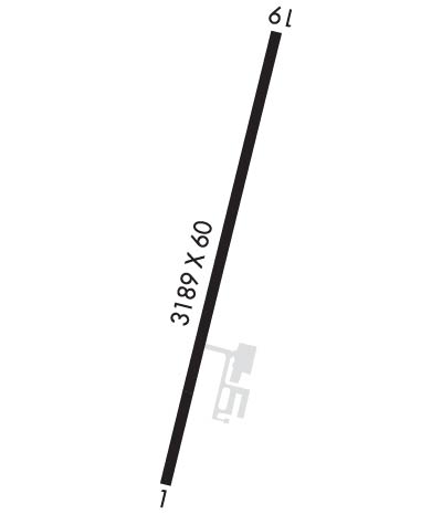
Runway Identifications
Runway Identification: 01/19
Length: 3189 ft
Width: 60 ft
Surface: ASPHALT-GOOD CONDITION
Edge lights: Medium Intensity

Treatment: NONE

 Runway: 01   Runway: 19
Mag heading: 15°Mag heading: 195°
Rwy Slope: -.45% DownRwy Slope: .45% Up
Approach: Approach:
Pattern: Left TrafficPattern: Left Traffic
Markings: NONPRECISION INSTRUMENTMarkings: NONPRECISION INSTRUMENT
Marking Condition: GOODMarking Condition: GOOD
Arresting Dev: Arresting Dev:
Lat & Long: N3355.3  W08147.7Lat. & Long.: N3355.9  W08147.6
Elev: 536.8 ft. MSLElev: 522.3 ft. MSL
TCH: 32 ft. AGLTCH:
Visual Glide Path: 3.00 degreesVisual Glide Path:
Displaced Threshold: NoDisplaced Threshold: No
Touchdown Zone: YESTouchdown Zone: YES
Touchdown Elev.: 539.2 feetTouchdown Elev.: 539.2 feet
Visual Glide Slope: 2-Light PAPI on LEFT side of RunwayVisual Glide Slope: 2-Light PAPI on LEFT side of Runway
RVR Equipment: RVR Equipment:
RVV Equipment: NORVV Equipment: NO
Approach Lights: Approach Lights:
REIL: NOREIL: NO
Centerline Lights: NOCenterline Lights: NO
Touchdown lights: NOTouchdown lights: NO
Runway Category: Runway with a Non-precision ApproachRunway Category: Runway with a Non-precision Approach
Declared Distances: Declared Distances:
Obstructions: TREEObstructions: TREE
Marked: NOT Marked/LightedMarked: NOT Marked/Lighted
Clearance slope: 16:1Clearance slope: 19:1
Obstruction height: 114 feet AGLObstruction height: 27 feet AGL
Dist. from runway: 2035 feetDist. from runway: 726 feet
Centerline offset: 271 right of centerlineCenterline offset: 190 feet left of centerline
Comments: Comments:
C:1/P: