Click here for more info on on SMS!

K6J2

ST GEORGE
ST GEORGE
SC
Time Zone: Eastern
Lat: N 3311.7
Long: W 08030.5
Elev: 85
Var: +06
Longest Runway: 3201
CTAF: 122.8

FBO & Flight Services info for K6J2

FBOs: Update your Fuel Prices

BLUE SKY ADVENTURPh: 843-563-6028
-
Freq: 122.8
Service
Jet
100LL
SAF
MoGas
Fuel Avail: NO FUEL AVAILABLE
Full        Last Update: 04/19/2024 00:01:45

Self        
If you are an FBO, call 1-203-262-1700 to update your info or email: FltPlan.Advertising@garmin.com
Advertise your FBO on FltPlan.com

Runway & Approach Info for K6J2
Rwy
Length
Land Dist**
Approach*
  Rwy
Length
Land Dist**
Approach*
05
3201x60  3201'          
 
  
23
  3201x60  3201'          
 
 * only ILS, LOC, LDA, and SDF approaches to a specific runway are shown
** For any Declared Landing Distance Available, please see A/FD or Approach plates
Runway Weight Capability (lbs.) Help
Runway IDSingle WheelDouble WheelDouble Tandem WheelDual Double Wheel
05/2321,00030,000N/AN/A
These numbers are Advisory and are not limits.   The Airport Manager should have more accurate Weight Limits
Approach Charts
Approaches    
Current Weather/Notams
Customs Information Send updates to Support@FltPlan.com
Customs Not Available
Database effective 04/18/2024
Airport Diagram of K6J2
Airport Diagram might not be current.

Facility Name: ST GEORGE
City Name: ST GEORGE
County: DORCHESTER
State abbrev: SC
State Name: SOUTH CAROLINA
   
Ownership: PUBLICLY OWNED
Use: OPEN TO THE PUBLIC
Owner's Name: DORCHESTER COUNTY
Address: PO BOX 416
 ST GEORGE, SC 29477
Owner's Phone: 843-563-0100
  
Manager's Name: DON HAY
Address: PO BOX 347, BOX 3
 HARLEYVILLE, SC 29448
Phone: 843-412-1999
   
FAA Region: SOUTHERN
FAA Field Office: ATL


Sunrise / Sunset times for ST GEORGE

DateSunriseSunset
04/18/24 Thursday6:4819:55
04/19/24 Friday6:4619:56
04/20/24 Saturday6:4519:57
04/21/24 Sunday6:4419:58
04/22/24 Monday6:4319:58
04/23/24 Tuesday6:4219:59
04/24/24 Wednesday6:4120:00
04/25/24 Thursday6:4020:01
04/26/24 Friday6:3920:01
04/27/24 Saturday6:3820:02
04/28/24 Sunday6:3620:03
04/29/24 Monday6:3520:04
04/30/24 Tuesday6:3420:04
05/01/24 Wednesday6:3320:05

Airport Facilities

Airport Attendance ScheduleUNATTENDED
Airport Status OPERATIONAL (This Status can change at any time - please check NOTAMS)
Airport Lighting ScheduleSS-SR
Airport Storage AvailableTie Downs
Extra Services AvailableNONE
Wind IndicatorYES - (lighted)
Control TowerNO
CTAF Frequency122.800
Unicom Frequency122.800
Rotating Beacon ColorWG
Segmented CircleYES
Landing FeeNO

Airport Inspection Data

Airport InspectedSTATE - performed by STATE AERONAUTICAL PERSONNEL
Inspection Date10/08/2021

Airport Services

Type of Fuel AvailableNone
Airframe Repair ServiceNONE
Power Plant Repair ServiceNONE

Geographic Data

LatitudeN3311.7
LongitudeW08030.5 (ESTIMATED)
Arpt Elevation84ft (SURVEYED)
Magnetic Variation06W
3 miles Eof ST GEORGE
Traffic Pattern Altitude
Sectional ChartCHARLOTTE

Aircraft Data

Operations (Reported)YearlyAvg. Daily
General Aviation Transient 7002
General Aviation Local 3001
Air Taxi 00
Commerical 00
Commuter 00
Military 00
Aircraft based on Field
General Aviation Singles 2
General Aviation Multi 0
Jet Aircraft 0
General Aviation Helicopters 0
Military Aircraft 0
Gliders 0
Ultralights 0

FAA Services

FSS on field NO
FSS tie-in ANDERSON
FSS Phone 1-800-WX-BRIEF
Who issues Notams AND
Notam D service at airport YES
ARTCC Name JACKSONVILLE

Federal Status

Airport Certification
Aircraft Rescue & Firefighting IndexNone
Airport of EntryNo
Custom Landing RightsNo
Joint Civil/MilitaryNo
Military Landing rightsYES

Federal Agreements

NATIONAL PLAN OF INTEGRATED AIRPORT SYSTEMS (NPIAS)
ASSURANCES PURSUANT TO TITLE VI, CIVIL RIGHTS ACT OF 1964
GRANT AGREEMENT HAS EXPIRED; HOWEVER, AGREEMENT REMAINS IN EFFECT FOR THIS FACILITY AS LONG AS IT IS PUBLIC USE.

Remarks

THIS AIRPORT HAS BEEN SURVEYED BY THE NATIONAL GEODETIC SURVEY.
FOR CD CTC CHARLESTON APCH AT 843-414-2832.
RWY 05 1 RY 05 HAS NPI APCH, BUT VISUAL MARKINGS.
Airport Communications & Frequencies:
CTAF Frequency:
122.800
Unicom Frequency:
122.800
CHARLESTON Primary Approach Frequencies:  
120.7
306.925
CHARLESTON Primary Departure Frequencies:  
120.7
306.925
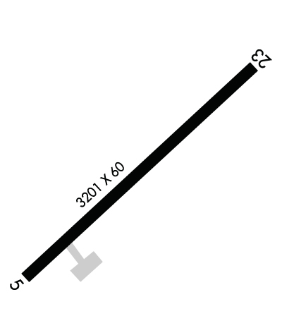
Runway Identifications
Runway Identification: 05/23
Length: 3201 ft
Width: 60 ft
Surface: ASPHALT-GOOD CONDITION
Edge lights: Low Intensity

Treatment: NONE

 Runway: 05   Runway: 23
Mag heading: 52°Mag heading: 232°
Rwy Slope: .00% DownRwy Slope: .00% Up
Approach: Approach:
Pattern: Left TrafficPattern: Left Traffic
Markings: BASICMarkings: BASIC
Marking Condition: FAIR; MARKING IS FADED.Marking Condition: FAIR; MARKING IS FADED.
Arresting Dev: Arresting Dev:
Lat & Long: N3311.5  W08030.7Lat. & Long.: N3311.9  W08030.3
Elev: 82.6 ft. MSLElev: 82.5 ft. MSL
TCH: TCH:
Visual Glide Path: Visual Glide Path:
Displaced Threshold: NoDisplaced Threshold: No
Touchdown Zone: YESTouchdown Zone: YES
Touchdown Elev.: 84.1 feetTouchdown Elev.: 84.1 feet
Visual Glide Slope: Visual Glide Slope:
RVR Equipment: RVR Equipment:
RVV Equipment: NORVV Equipment: NO
Approach Lights: Approach Lights:
REIL: NOREIL: NO
Centerline Lights: NOCenterline Lights: NO
Touchdown lights: NOTouchdown lights: NO
Runway Category: Runway with a Non-precision ApproachRunway Category: Runway with a Visual Approach
Declared Distances: Declared Distances:
Obstructions: TREEObstructions: TREE
Marked: NOT Marked/LightedMarked: NOT Marked/Lighted
Clearance slope: 10:1Clearance slope: 12:1
Obstruction height: 90 feet AGLObstruction height: 7 feet AGL
Dist. from runway: 1177 feetDist. from runway: 285 feet
Centerline offset: 186 left of centerlineCenterline offset: 69 feet right of centerline
Comments: TREES IN DITCHES EITHER SIDE OF RWY.Comments: TREES IN DITCHES EITHER SIDE OF RWY.
C:/P: