Click here for more info on on SMS!

K6F1

TALIHINA MUNI
TALIHINA
OK
Time Zone: Central
Lat: N 3442.5
Long: W 09504.4
Elev: 687
Var: -05
Longest Runway: 3300
CTAF: 122.9

FBO & Flight Services info for K6F1

FBOs: Update your Fuel Prices

AIRPORT MANAGERPh: 918-567-2194
-
Freq: 122.9
Service
Jet
100LL
SAF
MoGas
Fuel Avail: NO FUEL AVAILABLE
Full        Last Update: 04/23/2024 05:40:08

Self        
If you are an FBO, call 1-203-262-1700 to update your info or email: FltPlan.Advertising@garmin.com
Advertise your FBO on FltPlan.com

Runway & Approach Info for K6F1
Rwy
Length
Land Dist**
Approach*
  Rwy
Length
Land Dist**
Approach*
01
3300x60  3300'          
 
  
19
  3300x60  3300'          
 
 * only ILS, LOC, LDA, and SDF approaches to a specific runway are shown
** For any Declared Landing Distance Available, please see A/FD or Approach plates
Runway Weight Capability (lbs.) Help
Runway IDSingle WheelDouble WheelDouble Tandem WheelDual Double Wheel
01/1912,000N/AN/AN/A
These numbers are Advisory and are not limits.   The Airport Manager should have more accurate Weight Limits
Approach Charts
FltPlan does not have IFR approach charts available for K6F1.
Current Weather/Notams
Customs Information Send updates to Support@FltPlan.com
Customs Not Available
Database effective 05/16/2024
Airport Diagram of K6F1
Airport Diagram might not be current.

Facility Name: TALIHINA MUNI
City Name: TALIHINA
County: LATIMER
State abbrev: OK
State Name: OKLAHOMA
   
Ownership: PUBLICLY OWNED
Use: OPEN TO THE PUBLIC
Owner's Name: CITY OF TALIHINA
Address: CITY HALL PO BOX 457
 TALIHINA, OK 74571
Owner's Phone: 918-567-2194
  
Manager's Name: BRANN LINGENFELTER
Address: CITY HALL PO BOX 457
 TALIHINA, OK 74571
Phone: (918) 413-2088
   
FAA Region: SOUTHWEST
FAA Field Office: AOK


Sunrise / Sunset times for TALIHINA MUNI

DateSunriseSunset
04/22/24 Monday6:3919:59
04/23/24 Tuesday6:3820:00
04/24/24 Wednesday6:3720:00
04/25/24 Thursday6:3620:01
04/26/24 Friday6:3520:02
04/27/24 Saturday6:3320:03
04/28/24 Sunday6:3220:04
04/29/24 Monday6:3120:04
04/30/24 Tuesday6:3020:05
05/01/24 Wednesday6:2920:06
05/02/24 Thursday6:2820:07
05/03/24 Friday6:2720:08
05/04/24 Saturday6:2620:08
05/05/24 Sunday6:2520:09

Airport Facilities

Airport Attendance ScheduleUNATTENDED
Airport Status OPERATIONAL (This Status can change at any time - please check NOTAMS)
Airport Lighting ScheduleACTVT MIRL RWY 01/19 - CTAF.
Airport Storage AvailableTie Downs
Extra Services AvailableNONE
Wind IndicatorYES - (lighted)
Control TowerNO
CTAF Frequency122.900
Unicom Frequency
Rotating Beacon ColorWG
Segmented CircleYES
Landing FeeNO

Airport Inspection Data

Airport InspectedSTATE - performed by STATE AERONAUTICAL PERSONNEL
Inspection Date03/24/2022

Airport Services

Type of Fuel AvailableNone
Airframe Repair ServiceNone
Power Plant Repair ServiceNone

Geographic Data

LatitudeN3442.5
LongitudeW09504.4 (ESTIMATED)
Arpt Elevation687ft (SURVEYED)
Magnetic Variation05E
3 miles SWof TALIHINA
Traffic Pattern Altitude
Sectional ChartDALLAS-FT WORTH

Aircraft Data

Operations (Reported)YearlyAvg. Daily
General Aviation Transient 4501
General Aviation Local 00
Air Taxi 00
Commerical 00
Commuter 00
Military 00
Aircraft based on Field
General Aviation Singles 1
General Aviation Multi 0
Jet Aircraft 0
General Aviation Helicopters 0
Military Aircraft 0
Gliders 1
Ultralights 0

FAA Services

FSS on field NO
FSS tie-in MC ALESTER
FSS Phone 1-800-WX-BRIEF
Who issues Notams MLC
Notam D service at airport YES
ARTCC Name FORT WORTH

Federal Status

Airport Certification
Aircraft Rescue & Firefighting IndexNone
Airport of EntryNo
Custom Landing RightsNo
Joint Civil/MilitaryNo
Military Landing rightsYES

Federal Agreements

NATIONAL PLAN OF INTEGRATED AIRPORT SYSTEMS (NPIAS)
GRANT AGREEMENTS UNDER FAAP/ADAP/AIP
ASSURANCES PURSUANT TO TITLE VI, CIVIL RIGHTS ACT OF 1964

Remarks

FOR CD CTC FORT WORTH ARTCC AT 817-858-7584.
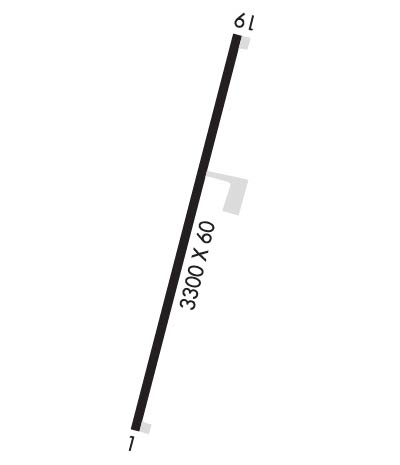
Runway Identifications
Runway Identification: 01/19
Length: 3300 ft
Width: 60 ft
Surface: ASPHALT-GOOD CONDITION
Edge lights: Medium Intensity

Treatment: NONE

 Runway: 01   Runway: 19
Mag heading: 14°Mag heading: 194°
Rwy Slope: .03% UpRwy Slope: -.03% Down
Approach: Approach:
Pattern: Left TrafficPattern: Left Traffic
Markings: BASICMarkings: BASIC
Marking Condition: GOODMarking Condition: GOOD
Arresting Dev: Arresting Dev:
Lat & Long: N3442.2  W09504.5Lat. & Long.: N3442.7  W09504.3
Elev: 683.4 ft. MSLElev: 684.3 ft. MSL
TCH: TCH:
Visual Glide Path: Visual Glide Path:
Displaced Threshold: NoDisplaced Threshold: No
Touchdown Zone: YESTouchdown Zone: YES
Touchdown Elev.: 687.0 feetTouchdown Elev.: 687.0 feet
Visual Glide Slope: Visual Glide Slope:
RVR Equipment: RVR Equipment:
RVV Equipment: NORVV Equipment: NO
Approach Lights: Approach Lights:
REIL: NOREIL: NO
Centerline Lights: NOCenterline Lights: NO
Touchdown lights: NOTouchdown lights: NO
Runway Category: Runway with a Visual ApproachRunway Category: Runway with a Visual Approach
Declared Distances: Declared Distances:
Obstructions: Obstructions: TREES
Marked: Marked: NOT Marked/Lighted
Clearance slope: 20:1Clearance slope: 6:1
Obstruction height: Obstruction height: 31 feet AGL
Dist. from runway: Dist. from runway: 408 feet
Centerline offset: Centerline offset: 100 feet right of centerline
Comments: Comments:
C:/P: