Current Weather/Notams (Metars, TAFs, Notams, NWS Forecast, PIREPS, and nearby weather)
Customs Information Send updates to Support@FltPlan.com
Customs Not Available
Database effective 04/18/2024
Airport Diagram might not be current.
|
| Facility Name: | GREENVILLE MUNI |
| City Name: | GREENVILLE |
| County: | MONTCALM |
| State abbrev: | MI |
| State Name: | MICHIGAN |
| | |
| Ownership: | PUBLICLY OWNED |
| Use: | OPEN TO THE PUBLIC |
| Owner's Name: | CITY OF GREENVILLE |
| Address: | 411 S LAFAYETTE ST |
| | GREENVILLE, MI 48838-2899 |
| Owner's Phone: | 616-754-5645 |
| | |
| Manager's Name: | PETER R JEPPESEN |
| Address: | 10593 SW GREENVILLE RD |
| | GREENVILLE, MI 48838-8743 |
| Phone: | 616-754-5534; CELL 989-287-2629. |
| | |
| FAA Region: | GREAT LAKES |
| FAA Field Office: | DET |
Runway Identifications
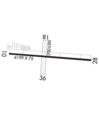
Runway Identification: 10/28Length: 4199 ft
Width: 75 ft
Surface: ASPHALT-GOOD CONDITION
Edge lights: Medium IntensityTreatment: NONE
| | Runway: 10 | | Runway: 28 |
| Mag heading: | 100° | Mag heading: | 280° |
| Rwy Slope: | -.45% Down | Rwy Slope: | .45% Up |
| Approach: | | Approach: | |
| Pattern: | Left Traffic | Pattern: | Left Traffic |
| Markings: | NONPRECISION INSTRUMENT | Markings: | NONPRECISION INSTRUMENT |
| Marking Condition: | GOOD | Marking Condition: | GOOD |
| Arresting Dev: | | Arresting Dev: | |
| Lat & Long: | N4308.6 W08515.7 | Lat. & Long.: | N4308.5 W08514.7 |
| Elev: | 854.6 ft. MSL | Elev: | 835.9 ft. MSL |
| TCH: | 27 ft. AGL | TCH: | 32 ft. AGL |
| Visual Glide Path: | 3.50 degrees | Visual Glide Path: | 3.00 degrees |
| Displaced Threshold: | No | Displaced Threshold: | No |
| Touchdown Zone: | YES | Touchdown Zone: | YES |
| Touchdown Elev.: | 854.6 feet | Touchdown Elev.: | 846.8 feet |
| Visual Glide Slope: | 4-Light PAPI on LEFT side of Runway | Visual Glide Slope: | 4-Light PAPI on LEFT side of Runway |
| RVR Equipment: | | RVR Equipment: | |
| RVV Equipment: | NO | RVV Equipment: | NO |
| Approach Lights: | | Approach Lights: | |
| REIL: | NO | REIL: | YES |
| Centerline Lights: | NO | Centerline Lights: | NO |
| Touchdown lights: | NO | Touchdown lights: | NO |
| Runway Category: | Runway with a Non-precision Approach | Runway Category: | Runway with a Non-precision Approach |
| Declared Distances: | | Declared Distances: | |
| Obstructions: | TREES | Obstructions: | TREES |
| Marked: | NOT Marked/Lighted | Marked: | NOT Marked/Lighted |
| Clearance slope: | 11:1 | Clearance slope: | 14:1 |
| Obstruction height: | 82 feet AGL | Obstruction height: | 28 feet AGL |
| Dist. from runway: | 1140 feet | Dist. from runway: | 598 feet |
| Centerline offset: | 390 right of centerline | Centerline offset: | 20 feet right of centerline |
| Comments: | | Comments: | |
Runway Identification: 18/36Length: 1730 ft
Width: 200 ft
Surface: GRASS-POOR CONDITION
Edge lights: Treatment: NONE
| | Runway: 18 | | Runway: 36 |
| Mag heading: | 190° | Mag heading: | 10° |
| Rwy Slope: | -.65% Down | Rwy Slope: | .65% Up |
| Approach: | | Approach: | |
| Pattern: | Left Traffic | Pattern: | Left Traffic |
| Markings: | | Markings: | |
| Marking Condition: | 3 FT YELLOW CONES. | Marking Condition: | RWY & DTHR MKD WITH 3 FT YELLOW CONES. |
| Arresting Dev: | | Arresting Dev: | |
| Lat & Long: | N4308.7 W08515.3 | Lat. & Long.: | N4308.4 W08515.3 |
| Elev: | 851.1 ft. MSL | Elev: | 839.9 ft. MSL |
| TCH: | | TCH: | |
| Visual Glide Path: | | Visual Glide Path: | |
| Displaced Threshold: | No | Displaced Threshold: | 378 feet |
| Touchdown Zone: | YES | Touchdown Zone: | YES |
| Touchdown Elev.: | 851.1 feet | Touchdown Elev.: | 851.1 feet |
| Visual Glide Slope: | | Visual Glide Slope: | |
| RVR Equipment: | | RVR Equipment: | |
| RVV Equipment: | NO | RVV Equipment: | NO |
| Approach Lights: | | Approach Lights: | |
| REIL: | NO | REIL: | NO |
| Centerline Lights: | NO | Centerline Lights: | NO |
| Touchdown lights: | NO | Touchdown lights: | NO |
| Runway Category: | Runway with a Visual Approach | Runway Category: | Runway with a Visual Approach |
| Declared Distances: | | Declared Distances: | |
| Obstructions: | TREES | Obstructions: | TREES |
| Marked: | NOT Marked/Lighted | Marked: | NOT Marked/Lighted |
| Clearance slope: | 2:1; APCH RATIO 3:1 TO DTHR OVR 64 FT TREE, 245 FT DIST, 145 FT L. | Clearance slope: | 10:1 |
| Obstruction height: | 40 feet AGL | Obstruction height: | 82 feet AGL |
| Dist. from runway: | 80 feet | Dist. from runway: | 826 feet |
| Centerline offset: | 125 left of centerline | Centerline offset: | 80 feet right of centerline |
| Comments: | | Comments: | |

