OPERATIONAL (This Status can change at any time - please check NOTAMS)
Airport Lighting Schedule
ACTVT MIRL RWY 10/28 - CTAF.
Airport Storage Available
Tie Downs, Hanger
Extra Services Available
NONE
Wind Indicator
YES - (lighted)
Control Tower
NO
CTAF Frequency
122.800
Unicom Frequency
122.800
Rotating Beacon Color
Segmented Circle
NO
Landing Fee
NO
Airport Inspection Data
Airport Inspected
STATE - performed by STATE AERONAUTICAL PERSONNEL
Inspection Date
07/15/2021
Airport Services
Type of Fuel Available
Grade 100LL
Airframe Repair Service
None
Power Plant Repair Service
None
Geographic Data
Latitude
N4254.8
Longitude
W07626.4 (ESTIMATED)
Arpt Elevation
1039ft (SURVEYED)
Magnetic Variation
12W
2 miles SW
of SKANEATELES
Traffic Pattern Altitude
800
Sectional Chart
NEW YORK
Aircraft Data
Operations (Reported)
Yearly
Avg. Daily
General Aviation Transient
1600
4
General Aviation Local
7500
21
Air Taxi
0
0
Commerical
0
0
Commuter
0
0
Military
8
0
Aircraft based on Field
General Aviation Singles
23
General Aviation Multi
2
Jet Aircraft
0
General Aviation Helicopters
0
Military Aircraft
0
Gliders
0
Ultralights
0
FAA Services
FSS on field
NO
FSS tie-in
BUFFALO
FSS Phone
1-800-WX-BRIEF
Who issues Notams
BUF
Notam D service at airport
YES
ARTCC Name
NEW YORK
Federal Status
Airport Certification
Aircraft Rescue & Firefighting Index
None
Airport of Entry
No
Custom Landing Rights
No
Joint Civil/Military
No
Military Landing rights
No
Remarks
THIS AIRPORT HAS BEEN SURVEYED BY THE NATIONAL GEODETIC SURVEY.
RWY 04/22 AVBL 15 MAY TO 15 OCT.
RY 28 TWO 55 FT POWER POLES 70 FT EITHER SIDE OF CNTRLN 700 FM THRESHOLD.
RY 10 3 FT FENCE 20 FT FM THLD ON BOTH SIDES 15 FT ROAD 30 FT FM THLD ON BOTH SIDES & 4 FT FENCE 80 FT FM THLD ON BOTH SIDES. -10 FT CULVERT/DITCH 50 FT LEFT OF CNTRLNE AT THRESHOLD.
FUEL AVBL 24 HRS SELF SER CREDIT CARD.
FOR CD CTC SYRACUSE APCH AT 315-455-6218.
RWY 04/2 2 HAS VARIATIONS IN RWY SFC.
RWY 10/2 8 RWY 10/28 NSTD MIRL; LGTS ARE 38 FT FM PAVEMENT EDGE.
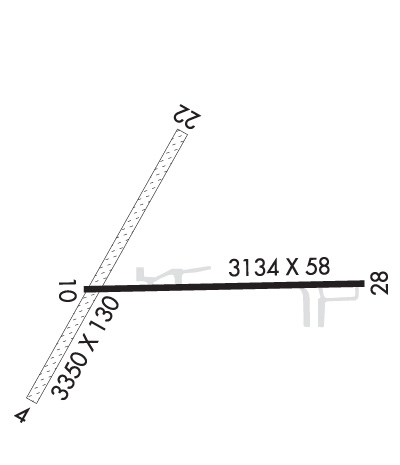
Length: 3350 ft Width: 130 ft Surface: GRASS-FAIR CONDITION Edge lights: Treatment: NONE
Runway: 04
Runway: 22
Mag heading:
37°
Mag heading:
217°
Rwy Slope:
-.81% Down
Rwy Slope:
.81% Up
Approach:
Approach:
Pattern:
Left Traffic
Pattern:
Left Traffic
Markings:
Markings:
Marking Condition:
Marking Condition:
Arresting Dev:
Arresting Dev:
Lat & Long:
N4254.6 W07626.7
Lat. & Long.:
N4255.1 W07626.4
Elev:
1039.0 ft. MSL
Elev:
1012.0 ft. MSL
TCH:
TCH:
Visual Glide Path:
Visual Glide Path:
Displaced Threshold:
No
Displaced Threshold:
No
Touchdown Zone:
YES
Touchdown Zone:
YES
Touchdown Elev.:
1039.0 feet
Touchdown Elev.:
1039.0 feet
Visual Glide Slope:
Visual Glide Slope:
RVR Equipment:
RVR Equipment:
RVV Equipment:
NO
RVV Equipment:
NO
Approach Lights:
Approach Lights:
REIL:
NO
REIL:
NO
Centerline Lights:
NO
Centerline Lights:
NO
Touchdown lights:
NO
Touchdown lights:
NO
Runway Category:
Runway with a Visual Approach
Runway Category:
Runway with a Visual Approach
Declared Distances:
Declared Distances:
Obstructions:
TREES; RWY 22 FENCE CROSSES RWY 10 FT FM THR BLO RWY ELEV.
Obstructions:
FENCE
Marked:
NOT Marked/Lighted
Marked:
NOT Marked/Lighted
Clearance slope:
1:1
Clearance slope:
3:1
Obstruction height:
37 feet AGL
Obstruction height:
44 feet AGL
Dist. from runway:
56 feet
Dist. from runway:
153 feet
Centerline offset:
80 left of centerline
Centerline offset:
99 feet left of centerline
Comments:
Comments:
Runway Identification: 10/28
Length: 3134 ft Width: 58 ft Surface: ASPHALT-GOOD CONDITION Edge lights: Non-Standard Lighting System Treatment: NONE
Runway: 10
Runway: 28
Mag heading:
107°
Mag heading:
287°
Rwy Slope:
-.38% Down
Rwy Slope:
.38% Up
Approach:
Approach:
Pattern:
Left Traffic
Pattern:
Left Traffic
Markings:
BASIC
Markings:
BASIC
Marking Condition:
GOOD
Marking Condition:
GOOD
Arresting Dev:
Arresting Dev:
Lat & Long:
N4254.8 W07626.6
Lat. & Long.:
N4254.8 W07625.9
Elev:
1006.0 ft. MSL
Elev:
994.0 ft. MSL
TCH:
TCH:
Visual Glide Path:
Visual Glide Path:
Displaced Threshold:
243 feet
Displaced Threshold:
No
Touchdown Zone:
YES
Touchdown Zone:
YES
Touchdown Elev.:
1003.0 feet
Touchdown Elev.:
1003.0 feet
Visual Glide Slope:
Visual Glide Slope:
RVR Equipment:
RVR Equipment:
RVV Equipment:
NO
RVV Equipment:
NO
Approach Lights:
Approach Lights:
REIL:
YES
REIL:
YES
Centerline Lights:
NO
Centerline Lights:
NO
Touchdown lights:
NO
Touchdown lights:
NO
Runway Category:
Runway with a Visual Approach
Runway Category:
Runway with a Visual Approach
Declared Distances:
Declared Distances:
Obstructions:
TREES
Obstructions:
TREES
Marked:
NOT Marked/Lighted
Marked:
NOT Marked/Lighted
Clearance slope:
4:1
Clearance slope:
1:1
Obstruction height:
59 feet AGL
Obstruction height:
51 feet AGL
Dist. from runway:
440 feet
Dist. from runway:
265 feet
Centerline offset:
78 right of centerline
Centerline offset:
113 feet right of centerline
Comments:
RWY 10 TWO 30 FT PWR POLES 80 FT EITHER SIDE OF CNTRLN 60 FT FM THLD; 3 FT FENCE OB 20 FT FM THLD 15 FT ROAD OB 30 FT FM THLD. 4 FT FENCE OB 80 FT FM THLD.
Comments:
RWY 28 33 FT TREE 138 FT FM RWY 120 FT RIGHT; 10 FT FARM ROAD CROSSES APPROACH END 117 FT FM THR.