Current Weather/Notams (Metars, TAFs, Notams, NWS Forecast, PIREPS, and nearby weather)
Customs Information Send updates to Support@FltPlan.com
Customs Not Available
Database effective 05/16/2024
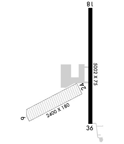
Airport Diagram might not be current. Facility Name: BUTLER MUNI City Name: BUTLER County: TAYLOR State abbrev: GA State Name: GEORGIA Ownership: PUBLICLY OWNED Use: OPEN TO THE PUBLIC Owner's Name: TAYLOR COUNTY Address: BOX 278 BUTLER, GA 31006 Owner's Phone: 478-862-3336 Manager's Name: CODY RUSTIN Address: BOX 553 BUTLER, GA 31006 Phone: 478-837-5490 FAA Region: SOUTHERN FAA Field Office: ATL
Runway Identifications Help
Runway Identification: 01/19 Length: 5002 ftWidth: 75 ftSurface: ASPHALT-GOOD CONDITIONEdge lights: Medium Intensity Treatment: NONE Runway: 01 Runway: 19 Mag heading: 5° Mag heading: 185° Rwy Slope: -.77% Down Rwy Slope: .77% Up Approach: Approach: Pattern: Left Traffic Pattern: Left Traffic Markings: NONPRECISION INSTRUMENT Markings: NONPRECISION INSTRUMENT Marking Condition: GOOD Marking Condition: GOOD Arresting Dev: Arresting Dev: Lat & Long: N3233.8 W08414.7 Lat. & Long.: N3234.6 W08414.7 Elev: 659.2 ft. MSL Elev: 620.6 ft. MSL TCH: 30 ft. AGL TCH: 33 ft. AGL Visual Glide Path: 2.75 degrees Visual Glide Path: 3.00 degrees Displaced Threshold: No Displaced Threshold: No Touchdown Zone: YES Touchdown Zone: YES Touchdown Elev.: 659.2 feet Touchdown Elev.: 646.7 feet Visual Glide Slope: 2-Light PAPI on LEFT side of Runway Visual Glide Slope: 2-Light PAPI on LEFT side of Runway RVR Equipment: RVR Equipment: RVV Equipment: NO RVV Equipment: NO Approach Lights: Approach Lights: REIL: NO REIL: NO Centerline Lights: NO Centerline Lights: NO Touchdown lights: NO Touchdown lights: NO Runway Category: Runway with a Non-precision Approach having visibility minimums greater than 3/4 mile Runway Category: Runway with a Non-precision Approach having visibility minimums greater than 3/4 mile Declared Distances: Declared Distances: Obstructions: TREES Obstructions: Marked: NOT Marked/Lighted Marked: Clearance slope: 20:1 Clearance slope: 50:1 Obstruction height: 39 feet AGL Obstruction height: Dist. from runway: 980 feet Dist. from runway: Centerline offset: 150 right of centerline Centerline offset: Comments: Comments:
Runway Identification: 06/24 Length: 2405 ftWidth: 180 ftSurface: GRASS-GOOD CONDITIONEdge lights: Treatment: NONE Runway: 06 Runway: 24 Mag heading: 68° Mag heading: 248° Rwy Slope: -.29% Down Rwy Slope: .29% Up Approach: Approach: Pattern: Left Traffic Pattern: Left Traffic Markings: NONSTANDARD Markings: NONSTANDARD Marking Condition: FAIR; RY 6/24 ENDS AND EDGES MARKED WITH INGROUND CONCRETE PADS. Marking Condition: FAIR Arresting Dev: Arresting Dev: Lat & Long: N3233.8 W08415.2 Lat. & Long.: N3234.0 W08414.8 Elev: 662.0 ft. MSL Elev: 655.0 ft. MSL TCH: TCH: Visual Glide Path: Visual Glide Path: Displaced Threshold: No Displaced Threshold: No Touchdown Zone: YES Touchdown Zone: YES Touchdown Elev.: 662.0 feet Touchdown Elev.: 662.0 feet Visual Glide Slope: Visual Glide Slope: RVR Equipment: RVR Equipment: RVV Equipment: NO RVV Equipment: NO Approach Lights: Approach Lights: REIL: NO REIL: NO Centerline Lights: NO Centerline Lights: NO Touchdown lights: NO Touchdown lights: NO Runway Category: Runway with a Visual Approach Runway Category: Runway with a Visual Approach Declared Distances: Declared Distances: Obstructions: TREES Obstructions: TREES Marked: NOT Marked/Lighted Marked: NOT Marked/Lighted Clearance slope: 6:1; RY 06 APCH RATIO 20:1 TO DSPLCD THLD, 54' TREE, 1280' FROM DISP THRESHOLD, 160' RIGHT. Clearance slope: 13:1 Obstruction height: 36 feet AGL Obstruction height: 56 feet AGL Dist. from runway: 216 feet Dist. from runway: 728 feet Centerline offset: 130 right of centerline Centerline offset: 146 feet left of centerline Comments: Comments: