Current Weather/Notams (Metars, TAFs, Notams, NWS Forecast, PIREPS, and nearby weather)
Customs Information Send updates to Support@FltPlan.com
Customs Not Available
Database effective 05/16/2024
Airport Diagram might not be current.
|
| Facility Name: | HUNTINGTON MUNI |
| City Name: | HUNTINGTON |
| County: | EMERY |
| State abbrev: | UT |
| State Name: | UTAH |
| | |
| Ownership: | PUBLICLY OWNED |
| Use: | OPEN TO THE PUBLIC |
| Owner's Name: | EMERY COUNTY |
| Address: | 75 EAST MAIN, P. O. BOX 907 |
| | CASTLE DALE, UT 84513 |
| Owner's Phone: | 435-381-2119 |
| | |
| Manager's Name: | JEFF GUYMON |
| Address: | 75 E MAIN ST., PO BOX 907 |
| | CASTLE DALE, UT 84513 |
| Phone: | 435-381-3589 |
| | |
| FAA Region: | NORTHWEST MOUNTAIN |
| FAA Field Office: | DEN |
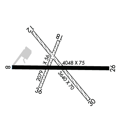
Runway Identifications
Runway Identification: 08/26Length: 4048 ft
Width: 75 ft
Surface: ASPHALT-GOOD CONDITION
Edge lights: Medium IntensityTreatment: NONE
| | Runway: 08 | | Runway: 26 |
| Mag heading: | 76° | Mag heading: | 256° |
| Rwy Slope: | -.78% Down | Rwy Slope: | .78% Up |
| Approach: | | Approach: | |
| Pattern: | Left Traffic | Pattern: | Left Traffic |
| Markings: | NONPRECISION INSTRUMENT | Markings: | NONPRECISION INSTRUMENT |
| Marking Condition: | FAIR | Marking Condition: | FAIR |
| Arresting Dev: | | Arresting Dev: | |
| Lat & Long: | N3921.7 W11055.4 | Lat. & Long.: | N3921.7 W11054.6 |
| Elev: | 5903.0 ft. MSL | Elev: | 5871.5 ft. MSL |
| TCH: | | TCH: | |
| Visual Glide Path: | | Visual Glide Path: | |
| Displaced Threshold: | 214 feet | Displaced Threshold: | No |
| Touchdown Zone: | NO | Touchdown Zone: | NO |
| Touchdown Elev.: | | Touchdown Elev.: | |
| Visual Glide Slope: | | Visual Glide Slope: | |
| RVR Equipment: | | RVR Equipment: | |
| RVV Equipment: | NO | RVV Equipment: | NO |
| Approach Lights: | | Approach Lights: | |
| REIL: | NO | REIL: | NO |
| Centerline Lights: | NO | Centerline Lights: | NO |
| Touchdown lights: | NO | Touchdown lights: | NO |
| Runway Category: | Runway with a Non-precision Approach | Runway Category: | Runway with a Non-precision Approach |
| Declared Distances: | | Declared Distances: | |
| Obstructions: | ROAD | Obstructions: | TREES |
| Marked: | NOT Marked/Lighted | Marked: | NOT Marked/Lighted |
| Clearance slope: | 7:1; APCH SLOPE 48:1 TO DTHR. | Clearance slope: | |
| Obstruction height: | 10 feet AGL | Obstruction height: | 15 feet AGL |
| Dist. from runway: | 270 feet | Dist. from runway: | 210 feet |
| Centerline offset: | 269 left of centerline | Centerline offset: | 154 feet left of centerline |
| Comments: | | Comments: | 15 FT TREES, 20 FT DSTC, 70 FT R. |
Runway Identification: 12/30Length: 3640 ft
Width: 70 ft
Surface: NATURAL SOIL-FAIR CONDITION
Edge lights: Treatment: NONE
| | Runway: 12 | | Runway: 30 |
| Mag heading: | 126° | Mag heading: | 306° |
| Rwy Slope: | -1.16% Down | Rwy Slope: | 1.16% Up |
| Approach: | | Approach: | |
| Pattern: | Left Traffic | Pattern: | Left Traffic |
| Markings: | | Markings: | |
| Marking Condition: | | Marking Condition: | |
| Arresting Dev: | | Arresting Dev: | |
| Lat & Long: | N3921.9 W11055.2 | Lat. & Long.: | N3921.4 W11054.7 |
| Elev: | 5915.0 ft. MSL | Elev: | 5872.7 ft. MSL |
| TCH: | | TCH: | |
| Visual Glide Path: | | Visual Glide Path: | |
| Displaced Threshold: | No | Displaced Threshold: | No |
| Touchdown Zone: | NO | Touchdown Zone: | NO |
| Touchdown Elev.: | | Touchdown Elev.: | |
| Visual Glide Slope: | | Visual Glide Slope: | |
| RVR Equipment: | | RVR Equipment: | |
| RVV Equipment: | NO | RVV Equipment: | NO |
| Approach Lights: | | Approach Lights: | |
| REIL: | NO | REIL: | NO |
| Centerline Lights: | NO | Centerline Lights: | NO |
| Touchdown lights: | NO | Touchdown lights: | NO |
| Runway Category: | Runway with a Visual Approach | Runway Category: | Runway with a Visual Approach |
| Declared Distances: | | Declared Distances: | |
| Obstructions: | FENCE; MARKED PLINE 360' FROM END RWY. | Obstructions: | TREES |
| Marked: | NOT Marked/Lighted | Marked: | NOT Marked/Lighted |
| Clearance slope: | 8:1 | Clearance slope: | 2:1 |
| Obstruction height: | 13 feet AGL | Obstruction height: | 22 feet AGL |
| Dist. from runway: | 110 feet | Dist. from runway: | 50 feet |
| Centerline offset: | | Centerline offset: | 70 feet left of centerline |
| Comments: | | Comments: | |
Runway Identification: 18/36Length: 2079 ft
Width: 56 ft
Surface: NATURAL SOIL-FAIR CONDITION
Edge lights: Treatment: NONE
| | Runway: 18 | | Runway: 36 |
| Mag heading: | 189° | Mag heading: | 9° |
| Rwy Slope: | -.65% Down | Rwy Slope: | .65% Up |
| Approach: | | Approach: | |
| Pattern: | Left Traffic | Pattern: | Left Traffic |
| Markings: | | Markings: | |
| Marking Condition: | | Marking Condition: | |
| Arresting Dev: | | Arresting Dev: | |
| Lat & Long: | N3921.8 W11055.0 | Lat. & Long.: | N3921.5 W11055.2 |
| Elev: | 5901.6 ft. MSL | Elev: | 5888.1 ft. MSL |
| TCH: | | TCH: | |
| Visual Glide Path: | | Visual Glide Path: | |
| Displaced Threshold: | No | Displaced Threshold: | No |
| Touchdown Zone: | NO | Touchdown Zone: | NO |
| Touchdown Elev.: | | Touchdown Elev.: | |
| Visual Glide Slope: | | Visual Glide Slope: | |
| RVR Equipment: | | RVR Equipment: | |
| RVV Equipment: | NO | RVV Equipment: | NO |
| Approach Lights: | | Approach Lights: | |
| REIL: | NO | REIL: | NO |
| Centerline Lights: | NO | Centerline Lights: | NO |
| Touchdown lights: | NO | Touchdown lights: | NO |
| Runway Category: | Runway with a Visual Approach | Runway Category: | Runway with a Visual Approach |
| Declared Distances: | | Declared Distances: | |

