Click here for more info on on SMS!

K63B

LIMINGTON-HARMON
LIMINGTON
ME
Time Zone: Eastern
Lat: N 4345.8
Long: W 07040.3
Elev: 292
Var: +17
Longest Runway: 2973
CTAF: 122.7

FBO & Flight Services info for K63B

FBOs: Update your Fuel Prices

LIMINGTON ARPTPh: 207-637-2121
-
Freq: 122.7
Service
Jet
100LL
SAF
MoGas
Fuel Avail: NO FUEL AVAILABLE
Full        Last Update: 04/23/2024 05:40:08

Self        
If you are an FBO, call 1-203-262-1700 to update your info or email: FltPlan.Advertising@garmin.com
Advertise your FBO on FltPlan.com

Runway & Approach Info for K63B
Rwy
Length
Land Dist**
Approach*
  Rwy
Length
Land Dist**
Approach*
11
2973x50  2973'          
 
  
29
  2973x50  2973'          
 
 * only ILS, LOC, LDA, and SDF approaches to a specific runway are shown
** For any Declared Landing Distance Available, please see A/FD or Approach plates
Runway Weight Capability (lbs.) Help
Runway IDSingle WheelDouble WheelDouble Tandem WheelDual Double Wheel
11/29N/AN/AN/AN/A
These numbers are Advisory and are not limits.   The Airport Manager should have more accurate Weight Limits
Approach Charts
FltPlan does not have IFR approach charts available for K63B.
Current Weather/Notams
Customs Information Send updates to Support@FltPlan.com
Customs Not Available
Database effective 05/16/2024
Airport Diagram of K63B
Airport Diagram might not be current.

Facility Name: LIMINGTON-HARMON
City Name: LIMINGTON
County: YORK
State abbrev: ME
State Name: MAINE
   
Ownership: PRIVATELY OWNED
Use: OPEN TO THE PUBLIC
Owner's Name: LIMINGTON AIRPORT AUTHORITY, LLC
Address: PO BOX 483
 LIMINGTON, ME 04049
Owner's Phone: 207-637-2121
  
Manager's Name: RONALD G MAIER
Address: 22 LUCILLE ST
 WEST BROOK, ME 04092
Phone: 207-318-4427
   
FAA Region: NEW ENGLAND
FAA Field Office: NONE


Sunrise / Sunset times for LIMINGTON-HARMON

DateSunriseSunset
04/22/24 Monday5:4719:36
04/23/24 Tuesday5:4619:37
04/24/24 Wednesday5:4419:38
04/25/24 Thursday5:4319:39
04/26/24 Friday5:4119:40
04/27/24 Saturday5:4019:42
04/28/24 Sunday5:3819:43
04/29/24 Monday5:3719:44
04/30/24 Tuesday5:3519:45
05/01/24 Wednesday5:3419:46
05/02/24 Thursday5:3219:47
05/03/24 Friday5:3119:49
05/04/24 Saturday5:3019:50
05/05/24 Sunday5:2819:51

Airport Facilities

Airport Attendance ScheduleUNATTENDED
Airport Status OPERATIONAL (This Status can change at any time - please check NOTAMS)
Airport Lighting ScheduleACTVT LIRL RWY 11/29 5 CLICKS - CTAF.
Airport Storage AvailableTie Downs, Hanger
Extra Services AvailableNONE
Wind IndicatorYES - (lighted)
Control TowerNO
CTAF Frequency122.700
Unicom Frequency122.700
Rotating Beacon Color
Segmented CircleNO
Landing FeeNO

Airport Inspection Data

Airport InspectedSTATE - performed by PRIVATE CONTRACT PERSONNEL
Inspection Date08/17/2022

Airport Services

Type of Fuel AvailableGrade 100LL; -1024 HR SELF-SERVE FUEL WITH MAJOR CREDIT CARD.
Airframe Repair ServiceNONE
Power Plant Repair ServiceNONE

Geographic Data

LatitudeN4345.8
LongitudeW07040.3 (ESTIMATED)
Arpt Elevation292ft (SURVEYED)
Magnetic Variation17W
3 miles Nof LIMINGTON
Traffic Pattern Altitude1100
Sectional ChartNEW YORK

Aircraft Data

Operations (Reported)YearlyAvg. Daily
General Aviation Transient 500014
General Aviation Local 1000027
Air Taxi 00
Commerical 00
Commuter 00
Military 250
Aircraft based on Field
General Aviation Singles 65
General Aviation Multi 2
Jet Aircraft 0
General Aviation Helicopters 1
Military Aircraft 0
Gliders 0
Ultralights 2

FAA Services

FSS on field NO
FSS tie-in BANGOR
FSS Phone 1-800-WX-BRIEF
Who issues Notams BGR
Notam D service at airport YES
ARTCC Name BOSTON

Federal Status

Airport Certification
Aircraft Rescue & Firefighting IndexNone
Airport of EntryNo
Custom Landing RightsNo
Joint Civil/MilitaryNo
Military Landing rightsNo

Remarks

THIS AIRPORT HAS BEEN SURVEYED BY THE NATIONAL GEODETIC SURVEY.
WILDLIFE ON OR INVOF ARPT.
FOR CD CTC PORTLAND APCH AT 207-874-7320, WHEN APCH CLSD CTC BOSTON ARTCC AT 603-879-6859.
RWY 11/2 9 SVRLY CRACKED, SHALLOW POTHOLES, LOOSE AGGRETATE ON RWY.
RWY 11/2 9 NON-STD LIRL. RWY 29 HAS ONE THR LGT 175 FT FM THR, RWY 11 HAS TWO THR LGTS 320 FT FM THR, RWY LGTS SPACED AT 400 FT, MANY LGTS MISG.
Airport Communications & Frequencies:
CTAF Frequency:
122.700
Unicom Frequency:
122.700
Primary Approach Frequencies:  
119.75
Primary Departure Frequencies:  
119.75
Runway Identifications
Runway Identification: 11/29
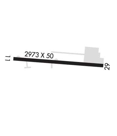
Length: 2973 ft
Width: 50 ft
Surface: ASPHALT-POOR CONDITION
Edge lights: Non-Standard Lighting System

Treatment: NONE

 Runway: 11   Runway: 29
Mag heading: 110°Mag heading: 290°
Rwy Slope: -.44% DownRwy Slope: .44% Up
Approach: Approach:
Pattern: Left TrafficPattern: Left Traffic
Markings: BASICMarkings: BASIC
Marking Condition: POOR; MKD AS BASIC, NRS DSPLCD 145 FT FM THR, NRS & CNTRLN FADED.Marking Condition: POOR; MKD AS BASIC, NRS DSPLCD 167 FT FM THR, NRS & CNTRLN FADED.
Arresting Dev: Arresting Dev:
Lat & Long: N4345.8  W07040.7Lat. & Long.: N4345.8  W07040.0
Elev: 292.3 ft. MSLElev: 279.1 ft. MSL
TCH: TCH:
Visual Glide Path: Visual Glide Path:
Displaced Threshold: NoDisplaced Threshold: No
Touchdown Zone: YESTouchdown Zone: YES
Touchdown Elev.: 292.3 feetTouchdown Elev.: 292.3 feet
Visual Glide Slope: Visual Glide Slope:
RVR Equipment: RVR Equipment:
RVV Equipment: NORVV Equipment: NO
Approach Lights: Approach Lights:
REIL: NOREIL: NO
Centerline Lights: NOCenterline Lights: NO
Touchdown lights: NOTouchdown lights: NO
Runway Category: Runway with a Visual ApproachRunway Category: Runway with a Visual Approach
Declared Distances: Declared Distances:
Obstructions: TREESObstructions: TREES
Marked: NOT Marked/LightedMarked: NOT Marked/Lighted
Clearance slope: Clearance slope: 2:1
Obstruction height: 25 feet AGLObstruction height: 55 feet AGL
Dist. from runway: 201 feetDist. from runway: 327 feet
Centerline offset: 140BCenterline offset: 125 feet right of centerline
Comments: +2 FT -20 FT BRUSH & TREES 0-200 FT FM THR, 0 FT B; +3 FT -5 FT DITCH 0-200 FT FM THR, 50 FT R OF CNTRLN.Comments: +15 FT ROAD 50-200 FT FM THR 0-125 FT R; +25 FT POLE 50 FT FM THR 100 FT R; +35 FT PWR LINE 0-200 FT FM THR, 125 FT R; FUEL TANK 0 FT FM THR, 125 FT R.
C:/P: