Approach Charts
| FltPlan does not have IFR approach charts available for K61R. |
Current Weather/Notams (Metars, TAFs, Notams, NWS Forecast, PIREPS, and nearby weather)
Customs Information Send updates to Support@FltPlan.com
Customs Not Available
Database effective 05/16/2024
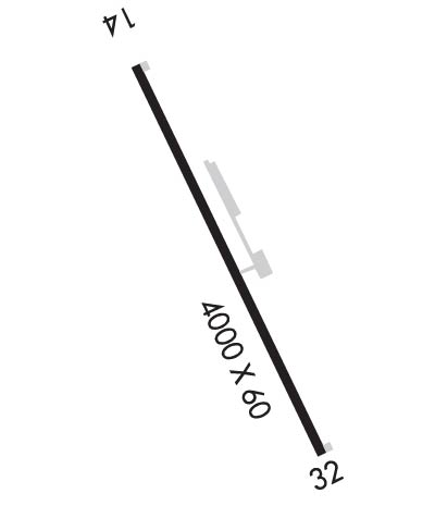
Airport Diagram might not be current.
|
| Facility Name: | NEWTON MUNI |
| City Name: | NEWTON |
| County: | NEWTON |
| State abbrev: | TX |
| State Name: | TEXAS |
| | |
| Ownership: | PUBLICLY OWNED |
| Use: | OPEN TO THE PUBLIC |
| Owner's Name: | NEWTON COUNTY |
| Address: | PO BOX 1380 |
| | NEWTON, TX 75966 |
| Owner's Phone: | 409-379-5691 |
| | |
| Manager's Name: | RONALD J. COCHRAN; COUNTY JUDGE/AMGR |
| Address: | PO BOX 1380 |
| | NEWTON, TX 75966 |
| Phone: | 409-379-5691; AFTR HRS AMGR PH 409-384-0722 |
| | |
| FAA Region: | SOUTHWEST |
| FAA Field Office: | TEX |
Runway Identifications
Runway Identification: 14/32Length: 4000 ft
Width: 60 ft
Surface: ASPHALT-GOOD CONDITION
Edge lights: Low IntensityTreatment: NONE
| | Runway: 14 | | Runway: 32 |
| Mag heading: | 140° | Mag heading: | 320° |
| Rwy Slope: | -.93% Down | Rwy Slope: | .93% Up |
| Approach: | | Approach: | |
| Pattern: | Left Traffic | Pattern: | Left Traffic |
| Markings: | BASIC | Markings: | BASIC |
| Marking Condition: | GOOD | Marking Condition: | GOOD |
| Arresting Dev: | | Arresting Dev: | |
| Lat & Long: | N3053.3 W09344.8 | Lat. & Long.: | N3052.8 W09344.3 |
| Elev: | 322.0 ft. MSL | Elev: | 285.0 ft. MSL |
| TCH: | | TCH: | |
| Visual Glide Path: | | Visual Glide Path: | |
| Displaced Threshold: | No | Displaced Threshold: | No |
| Touchdown Zone: | NO | Touchdown Zone: | NO |
| Touchdown Elev.: | | Touchdown Elev.: | |
| Visual Glide Slope: | | Visual Glide Slope: | |
| RVR Equipment: | | RVR Equipment: | |
| RVV Equipment: | NO | RVV Equipment: | NO |
| Approach Lights: | | Approach Lights: | |
| REIL: | NO | REIL: | NO |
| Centerline Lights: | NO | Centerline Lights: | NO |
| Touchdown lights: | NO | Touchdown lights: | NO |
| Runway Category: | Runway with a Visual Approach | Runway Category: | Runway with a Visual Approach |
| Declared Distances: | | Declared Distances: | |
| Obstructions: | TREES | Obstructions: | TREES |
| Marked: | NOT Marked/Lighted | Marked: | NOT Marked/Lighted |
| Clearance slope: | 22:1 | Clearance slope: | 11:1 |
| Obstruction height: | 65 feet AGL | Obstruction height: | 75 feet AGL |
| Dist. from runway: | 1650 feet | Dist. from runway: | 1030 feet |
| Centerline offset: | 510B | Centerline offset: | 175 feet left of centerline |
| Comments: | | Comments: | |

