
| ||||||||||||||||||||||||||||||||||||||||||||
| ||||||||||||||||||||||||||||||||||||||||||||
| Rwy | Rwy | |||||||
| 3402x60 | 3402' | 3402x60 | 3402' | |||||
| Runway ID | Single Wheel | Double Wheel | Double Tandem Wheel | Dual Double Wheel |
| 04/22 | 30,000 | N/A | N/A | N/A |
| These numbers are Advisory and are not limits. The Airport Manager should have more accurate Weight Limits | ||||
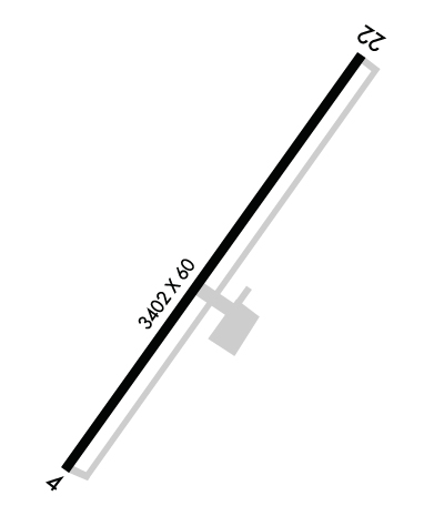 Airport Diagram might not be current. | |
| Facility Name: | P K AIRPARK |
| City Name: | RAEFORD |
| County: | HOKE |
| State abbrev: | NC |
| State Name: | NORTH CAROLINA |
| Ownership: | PRIVATELY OWNED |
| Use: | OPEN TO THE PUBLIC |
| Owner's Name: | BILLIE THACKER |
| Address: | PO DRAWER 1510 |
| RAEFORD, NC 28376 | |
| Owner's Phone: | 910-875-3261 |
| Manager's Name: | JOEY D'ANNUNZIO |
| Address: | 155 AIRPORT DRIVE |
| RAEFORD, NC 28376 | |
| Phone: | (910) 904-0000 |
| FAA Region: | SOUTHERN |
| FAA Field Office: | MEM |
| Date | Sunrise | Sunset |
|---|---|---|
| 04/18/24 Thursday | 6:40 | 19:52 |
| 04/19/24 Friday | 6:39 | 19:53 |
| 04/20/24 Saturday | 6:38 | 19:54 |
| 04/21/24 Sunday | 6:36 | 19:55 |
| 04/22/24 Monday | 6:35 | 19:56 |
| 04/23/24 Tuesday | 6:34 | 19:56 |
| 04/24/24 Wednesday | 6:33 | 19:57 |
| 04/25/24 Thursday | 6:32 | 19:58 |
| 04/26/24 Friday | 6:31 | 19:59 |
| 04/27/24 Saturday | 6:29 | 20:00 |
| 04/28/24 Sunday | 6:28 | 20:00 |
| 04/29/24 Monday | 6:27 | 20:01 |
| 04/30/24 Tuesday | 6:26 | 20:02 |
| 05/01/24 Wednesday | 6:25 | 20:03 |
| Airport Attendance Schedule | 7 Days A Week 0830-DUSK |
| Airport Status | OPERATIONAL (This Status can change at any time - please check NOTAMS) |
| Airport Lighting Schedule | |
| Airport Storage Available | Tie Downs |
| Extra Services Available | Parachute Jumping, Annual Surveying |
| Wind Indicator | YES - (lighted) |
| Control Tower | NO |
| CTAF Frequency | 123.000 |
| Unicom Frequency | 123.000 |
| Rotating Beacon Color | WG |
| Segmented Circle | YES |
| Landing Fee | NO |
| Airport Inspected | STATE - performed by STATE AERONAUTICAL PERSONNEL |
| Inspection Date | 07/29/2022 |
| Type of Fuel Available | Grade 100LL, JET A |
| Airframe Repair Service | NONE |
| Power Plant Repair Service | NONE |
| Latitude | N3501.2 |
| Longitude | W07911.5 (ESTIMATED) |
| Arpt Elevation | 304ft (SURVEYED) |
| Magnetic Variation | 09W |
| 3 miles NE | of RAEFORD |
| Traffic Pattern Altitude | |
| Sectional Chart | CHARLOTTE |
| Operations (Reported) | Yearly | Avg. Daily |
|---|---|---|
| General Aviation Transient | 500 | 1 |
| General Aviation Local | 18000 | 49 |
| Air Taxi | 0 | 0 |
| Commerical | 0 | 0 |
| Commuter | 0 | 0 |
| Military | 5000 | 14 |
| Aircraft based on Field | |
|---|---|
| General Aviation Singles | 2 |
| General Aviation Multi | 6 |
| Jet Aircraft | 0 |
| General Aviation Helicopters | 0 |
| Military Aircraft | 0 |
| Gliders | 0 |
| Ultralights | 0 |
| FSS on field | NO |
| FSS tie-in | RALEIGH |
| FSS Phone | 1-800-WX-BRIEF |
| Who issues Notams | RDU |
| Notam D service at airport | YES |
| ARTCC Name | WASHINGTON |
| Airport Certification | |
| Aircraft Rescue & Firefighting Index | None |
| Airport of Entry | No |
| Custom Landing Rights | No |
| Joint Civil/Military | No |
| Military Landing rights | YES |
| THIS AIRPORT HAS BEEN SURVEYED BY THE NATIONAL GEODETIC SURVEY. |
| CAUTION: LOW FLYING MIL ACFT IN AREA; ARPT LCTD WITHIN AN MOA. |
| FRQ PRCHT ACT TO TARGET 300 FT SE OF TERMINAL APRON. |
| ACFT IN VICINITY MONITOR 123.5. |
| FLY ONE MILE DOWN WIND LEG TO PREVENT CONFLICTS WITH PAJA (DROP ZONE SOUTHEAST FROM RWY). |
| AFTER HOURS SVC 910-578-4401. |
| MONITOR FREQ 123.5 FOR PAJA. |
| FOR CD CTC WASHINGTON ARTCC AT 703-771-3587. |
| CTN DO NOT OVERFLY AIRPORT DUE TO PAJA. |
Airport Communications & Frequencies:
| ||||||||||||||
| Runway: 04 | Runway: 22 | ||
| Mag heading: | 42° | Mag heading: | 222° |
| Rwy Slope: | .35% Up | Rwy Slope: | -.35% Down |
| Approach: | Approach: | ||
| Pattern: | Left Traffic | Pattern: | Right Traffic |
| Markings: | NONPRECISION INSTRUMENT | Markings: | NONPRECISION INSTRUMENT |
| Marking Condition: | GOOD | Marking Condition: | GOOD |
| Arresting Dev: | Arresting Dev: | ||
| Lat & Long: | N3501.0 W07911.6 | Lat. & Long.: | N3501.4 W07911.3 |
| Elev: | 292.0 ft. MSL | Elev: | 304.0 ft. MSL |
| TCH: | TCH: | ||
| Visual Glide Path: | Visual Glide Path: | ||
| Displaced Threshold: | No | Displaced Threshold: | No |
| Touchdown Zone: | YES | Touchdown Zone: | YES |
| Touchdown Elev.: | 292.0 feet | Touchdown Elev.: | 304.0 feet |
| Visual Glide Slope: | Visual Glide Slope: | ||
| RVR Equipment: | RVR Equipment: | ||
| RVV Equipment: | NO | RVV Equipment: | NO |
| Approach Lights: | Approach Lights: | ||
| REIL: | NO | REIL: | NO |
| Centerline Lights: | NO | Centerline Lights: | NO |
| Touchdown lights: | NO | Touchdown lights: | NO |
| Runway Category: | Runway with a Visual Approach | Runway Category: | Runway with a Visual Approach |
| Declared Distances: | Declared Distances: | ||
| Obstructions: | TREES | Obstructions: | TREES |
| Marked: | NOT Marked/Lighted | Marked: | NOT Marked/Lighted |
| Clearance slope: | 6:1 | Clearance slope: | 10:1 |
| Obstruction height: | 63 feet AGL | Obstruction height: | 41 feet AGL |
| Dist. from runway: | 631 feet | Dist. from runway: | 615 feet |
| Centerline offset: | 66 right of centerline | Centerline offset: | 42 feet left of centerline |
| Comments: | Comments: | HAS 15 FT BRUSH 0-200 FT FM THR OFFSET 121 FT R OF CNTRLN. |
