Approach Charts
| FltPlan does not have IFR approach charts available for K5U5. |
Current Weather/Notams (Metars, TAFs, Notams, NWS Forecast, PIREPS, and nearby weather)
Customs Information Send updates to Support@FltPlan.com
Customs Not Available
Database effective 05/16/2024
Airport Diagram might not be current.
|
| Facility Name: | FAIRFIELD |
| City Name: | FAIRFIELD |
| County: | TETON |
| State abbrev: | MT |
| State Name: | MONTANA |
| | |
| Ownership: | PUBLICLY OWNED |
| Use: | OPEN TO THE PUBLIC |
| Owner's Name: | CITY OF FAIRFIELD/TETON CO |
| Address: | CITY HALL |
| | FAIRFIELD, MT 59436 |
| Owner's Phone: | (406) 467-2510 |
| | |
| Manager's Name: | SCOTT GASVODA |
| Address: | PO BOX 73 |
| | FAIRFIELD, MT 59436 |
| Phone: | 406-590-2836 |
| | |
| FAA Region: | NORTHWEST MOUNTAIN |
| FAA Field Office: | HLN |
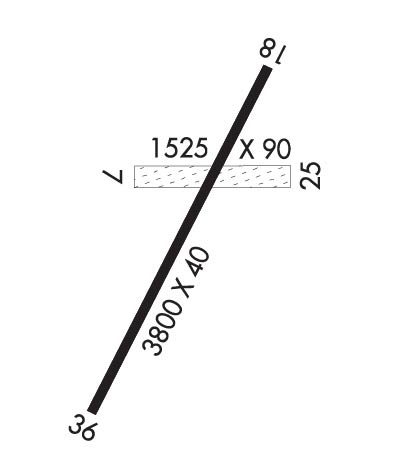
Runway Identifications
Runway Identification: 07/25Length: 1525 ft
Width: 90 ft
Surface: GRASS-GOOD CONDITION
Edge lights: Treatment: NONE
| | Runway: 07 | | Runway: 25 |
| Mag heading: | 74° | Mag heading: | 254° |
| Rwy Slope: | -.59% Down | Rwy Slope: | .59% Up |
| Approach: | | Approach: | |
| Pattern: | Left Traffic | Pattern: | Left Traffic |
| Markings: | NONSTANDARD | Markings: | NONSTANDARD |
| Marking Condition: | GOOD; WHITE CONES MARKING RUNWAY 07/25 | Marking Condition: | GOOD; WHITE CONES MARKING 07/25 |
| Arresting Dev: | | Arresting Dev: | |
| Lat & Long: | N4738.1 W11159.0 | Lat. & Long.: | N4738.1 W11158.6 |
| Elev: | 3991.0 ft. MSL | Elev: | 3982.0 ft. MSL |
| TCH: | | TCH: | |
| Visual Glide Path: | | Visual Glide Path: | |
| Displaced Threshold: | No | Displaced Threshold: | No |
| Touchdown Zone: | NO | Touchdown Zone: | NO |
| Touchdown Elev.: | | Touchdown Elev.: | |
| Visual Glide Slope: | | Visual Glide Slope: | |
| RVR Equipment: | | RVR Equipment: | |
| RVV Equipment: | NO | RVV Equipment: | NO |
| Approach Lights: | | Approach Lights: | |
| REIL: | NO | REIL: | NO |
| Centerline Lights: | NO | Centerline Lights: | NO |
| Touchdown lights: | NO | Touchdown lights: | NO |
| Runway Category: | Runway with a Visual Approach | Runway Category: | Runway with a Visual Approach |
| Declared Distances: | | Declared Distances: | |
| Obstructions: | FENCE | Obstructions: | FENCE; RY 25 2 FT BERMS 10 FT FROM EOR. |
| Marked: | NOT Marked/Lighted | Marked: | NOT Marked/Lighted |
| Clearance slope: | 2:1 | Clearance slope: | 7:1 |
| Obstruction height: | 5 feet AGL | Obstruction height: | 4 feet AGL |
| Dist. from runway: | 14 feet | Dist. from runway: | 30 feet |
| Centerline offset: | | Centerline offset: | |
| Comments: | | Comments: | |
Runway Identification: 18/36Length: 3800 ft
Width: 40 ft
Surface: ASPHALT-GOOD CONDITION
Edge lights: Non-Standard Lighting SystemTreatment: NONE
| | Runway: 18 | | Runway: 36 |
| Mag heading: | 186° | Mag heading: | 6° |
| Rwy Slope: | .24% Up | Rwy Slope: | -.24% Down |
| Approach: | | Approach: | |
| Pattern: | Left Traffic | Pattern: | Left Traffic |
| Markings: | NONE | Markings: | NONE |
| Marking Condition: | | Marking Condition: | |
| Arresting Dev: | | Arresting Dev: | |
| Lat & Long: | N4738.3 W11158.7 | Lat. & Long.: | N4737.7 W11159.1 |
| Elev: | 3960.0 ft. MSL | Elev: | 3969.0 ft. MSL |
| TCH: | | TCH: | |
| Visual Glide Path: | | Visual Glide Path: | |
| Displaced Threshold: | No | Displaced Threshold: | No |
| Touchdown Zone: | NO | Touchdown Zone: | NO |
| Touchdown Elev.: | | Touchdown Elev.: | |
| Visual Glide Slope: | | Visual Glide Slope: | |
| RVR Equipment: | | RVR Equipment: | |
| RVV Equipment: | NO | RVV Equipment: | NO |
| Approach Lights: | | Approach Lights: | |
| REIL: | NO | REIL: | NO |
| Centerline Lights: | NO | Centerline Lights: | NO |
| Touchdown lights: | NO | Touchdown lights: | NO |
| Runway Category: | Runway with a Visual Approach | Runway Category: | Runway with a Visual Approach |
| Declared Distances: | | Declared Distances: | |
| Comments: | HAS -6 FT IRRIGATION DITCH 171 FT FM EOR; 0B & +4 FENCE 153 FT FM EOR 0B. | Comments: | |

