Approach Charts
| FltPlan does not have IFR approach charts available for K5S6. |
Current Weather/Notams (Metars, TAFs, Notams, NWS Forecast, PIREPS, and nearby weather)
Customs Information Send updates to Support@FltPlan.com
Customs Not Available
Database effective 04/18/2024
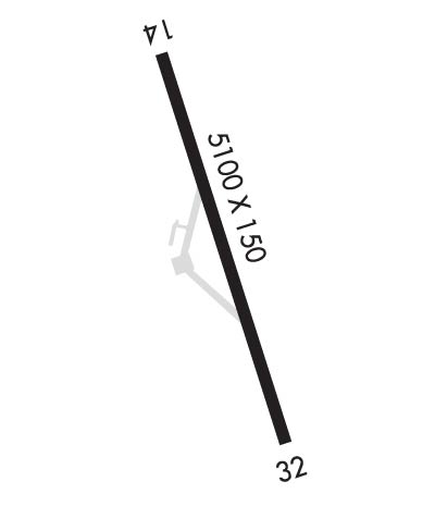
Airport Diagram might not be current.
|
| Facility Name: | CAPE BLANCO STATE |
| City Name: | SIXES |
| County: | CURRY |
| State abbrev: | OR |
| State Name: | OREGON |
| | |
| Ownership: | PUBLICLY OWNED |
| Use: | OPEN TO THE PUBLIC |
| Owner's Name: | OREGON DEPT OF AVIATION |
| Address: | 3040 25TH ST SE |
| | SALEM, OR 97310 |
| Owner's Phone: | 503-378-4880 |
| | |
| Manager's Name: | STATE AIRPORTS MANAGER |
| Address: | 3040 25TH ST SE |
| | SALEM, OR 97302 |
| Phone: | 503-378-4880 |
| | |
| FAA Region: | NORTHWEST MOUNTAIN |
| FAA Field Office: | SEA |
Runway Identifications
Runway Identification: 14/32Length: 5100 ft
Width: 150 ft
Surface: ASPHALT-FAIR CONDITION
Edge lights: Treatment: NONE
| | Runway: 14 | | Runway: 32 |
| Mag heading: | 141° | Mag heading: | 321° |
| Rwy Slope: | .02% Up | Rwy Slope: | -.02% Down |
| Approach: | | Approach: | |
| Pattern: | Left Traffic | Pattern: | Left Traffic |
| Markings: | BASIC | Markings: | BASIC |
| Marking Condition: | GOOD | Marking Condition: | GOOD |
| Arresting Dev: | | Arresting Dev: | |
| Lat & Long: | N4251.9 W12431.3 | Lat. & Long.: | N4251.1 W12430.9 |
| Elev: | 201.0 ft. MSL | Elev: | 202.0 ft. MSL |
| TCH: | | TCH: | |
| Visual Glide Path: | | Visual Glide Path: | |
| Displaced Threshold: | No | Displaced Threshold: | No |
| Touchdown Zone: | NO | Touchdown Zone: | NO |
| Touchdown Elev.: | | Touchdown Elev.: | |
| Visual Glide Slope: | | Visual Glide Slope: | |
| RVR Equipment: | | RVR Equipment: | |
| RVV Equipment: | NO | RVV Equipment: | NO |
| Approach Lights: | | Approach Lights: | |
| REIL: | NO | REIL: | NO |
| Centerline Lights: | NO | Centerline Lights: | NO |
| Touchdown lights: | NO | Touchdown lights: | NO |
| Runway Category: | Runway with a Visual Approach | Runway Category: | Runway with a Visual Approach |
| Declared Distances: | | Declared Distances: | |
| Obstructions: | TREES | Obstructions: | BRUSH |
| Marked: | NOT Marked/Lighted | Marked: | NOT Marked/Lighted |
| Clearance slope: | 16:1; CTLNG OBSTN EXCEEDS A 45 DEG SLP. | Clearance slope: | 14:1 |
| Obstruction height: | 14 feet AGL | Obstruction height: | 15 feet AGL |
| Dist. from runway: | 436 feet | Dist. from runway: | 424 feet |
| Centerline offset: | | Centerline offset: | |
| Comments: | 113 FT EITHER SIDE OF RWY BRUSH & TREES. | Comments: | 115 FT FM RWY BRUSH & TREES BOTH SIDES. |

