Click here for more info on on SMS!

K5N2

PRENTICE
PRENTICE
WI
Time Zone: Central
Lat: N 4532.3
Long: W 09016.6
Elev: 1579
Var: -00
Longest Runway: 3134
CTAF: 123.0

FBO & Flight Services info for K5N2

FBOs: Update your Fuel Prices

UNATTENDED
-
-
Service
Jet
100LL
SAF
MoGas
Fuel Avail: NO FUEL AVAILABLE
Full        Last Update: 04/20/2024 05:45:18

Self        
If you are an FBO, call 1-203-262-1700 to update your info or email: FltPlan.Advertising@garmin.com
Advertise your FBO on FltPlan.com

Runway & Approach Info for K5N2
Rwy
Length
Land Dist**
Approach*
  Rwy
Length
Land Dist**
Approach*
09
3134x60  2797'          
 
  
27
  3134x60  3134'          
 
 * only ILS, LOC, LDA, and SDF approaches to a specific runway are shown
** For any Declared Landing Distance Available, please see A/FD or Approach plates
Runway Weight Capability (lbs.) Help
Runway IDSingle WheelDouble WheelDouble Tandem WheelDual Double Wheel
09/27N/AN/AN/AN/A
These numbers are Advisory and are not limits.   The Airport Manager should have more accurate Weight Limits
Approach Charts
FltPlan does not have IFR approach charts available for K5N2.
Current Weather/Notams
Customs Information Send updates to Support@FltPlan.com
Customs Not Available
Database effective 04/18/2024
Airport Diagram of K5N2
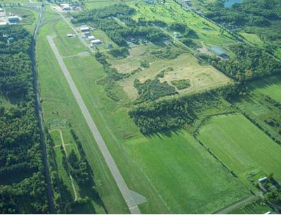
Airport Diagram might not be current.

Facility Name: PRENTICE
City Name: PRENTICE
County: PRICE
State abbrev: WI
State Name: WISCONSIN
   
Ownership: PUBLICLY OWNED
Use: OPEN TO THE PUBLIC
Owner's Name: VILLAGE OF PRENTICE
Address: 403 CENTER ST
 PRENTICE, WI 54556
Owner's Phone: 715-428-2124
  
Manager's Name: DALE HEIKKINEN
Address: PO BOX 108
 PRENTICE, WI 54556
Phone: 715-360-2000
   
FAA Region: GREAT LAKES
FAA Field Office: CHI
Courtesy of Prentice Municipal Airport 2011


Click here for full scale & interactive Sectional view of K5N2


Sunrise / Sunset times for PRENTICE

DateSunriseSunset
04/19/24 Friday6:0719:54
04/20/24 Saturday6:0619:55
04/21/24 Sunday6:0419:56
04/22/24 Monday6:0219:57
04/23/24 Tuesday6:0119:59
04/24/24 Wednesday5:5920:00
04/25/24 Thursday5:5720:01
04/26/24 Friday5:5620:03
04/27/24 Saturday5:5420:04
04/28/24 Sunday5:5320:05
04/29/24 Monday5:5120:06
04/30/24 Tuesday5:4920:08
05/01/24 Wednesday5:4820:09
05/02/24 Thursday5:4620:10

Airport Facilities

Airport Attendance ScheduleUNATTENDED
Airport Status OPERATIONAL (This Status can change at any time - please check NOTAMS)
Airport Lighting ScheduleACTVT MIRL RY 09/27 & TWY LGTS - CTAF.
Airport Storage AvailableTie Downs
Extra Services AvailableNONE
Wind IndicatorYES - (lighted)
Control TowerNO
CTAF Frequency123.000
Unicom Frequency123.000
Rotating Beacon ColorWG
Segmented CircleYES
Landing FeeNO

Airport Inspection Data

Airport InspectedSTATE - performed by STATE AERONAUTICAL PERSONNEL
Inspection Date06/22/2023

Airport Services

Type of Fuel AvailableNone
Airframe Repair ServiceNONE
Power Plant Repair ServiceNONE

Geographic Data

LatitudeN4532.3
LongitudeW09016.6 (ESTIMATED)
Arpt Elevation1578ft (SURVEYED)
Magnetic Variation00E
1 miles Eof PRENTICE
Traffic Pattern Altitude
Sectional ChartGREEN BAY

Aircraft Data

Operations (Reported)YearlyAvg. Daily
General Aviation Transient 10003
General Aviation Local 5001
Air Taxi 200
Commerical 00
Commuter 00
Military 00
Aircraft based on Field
General Aviation Singles 0
General Aviation Multi 0
Jet Aircraft 0
General Aviation Helicopters 0
Military Aircraft 0
Gliders 0
Ultralights 1

FAA Services

FSS on field NO
FSS tie-in GREEN BAY
FSS Phone 1-800-WX-BRIEF
Who issues Notams GRB
Notam D service at airport YES
ARTCC Name MINNEAPOLIS

Federal Status

Airport Certification
Aircraft Rescue & Firefighting IndexNone
Airport of EntryNo
Custom Landing RightsNo
Joint Civil/MilitaryNo
Military Landing rightsNo

Remarks

FOR CD CTC MINNEAPOLIS ARTCC AT 651-463-5588.
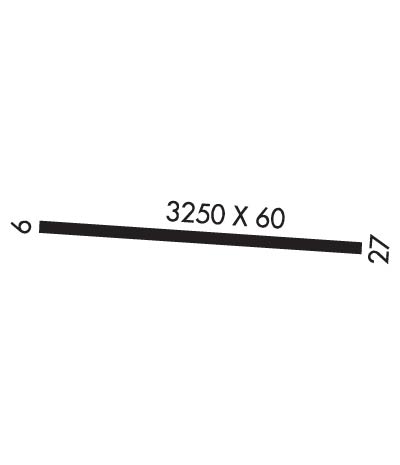
Runway Identifications
Runway Identification: 09/27
Length: 3134 ft
Width: 60 ft
Surface: ASPHALT-FAIR CONDITION
Edge lights: Medium Intensity

Treatment: NONE

 Runway: 09   Runway: 27
Mag heading: N/AMag heading: N/A
Rwy Slope: .68% UpRwy Slope: -.68% Down
Approach: Approach:
Pattern: Left TrafficPattern: Left Traffic
Markings: BASICMarkings: BASIC
Marking Condition: FAIRMarking Condition: FAIR
Arresting Dev: Arresting Dev:
Lat & Long: N4532.3  W09016.9Lat. & Long.: N4532.3  W09016.2
Elev: 1557.1 ft. MSLElev: 1578.5 ft. MSL
TCH: TCH:
Visual Glide Path: Visual Glide Path:
Displaced Threshold: 337 feetDisplaced Threshold: No
Touchdown Zone: NOTouchdown Zone: NO
Touchdown Elev.: Touchdown Elev.:
Visual Glide Slope: Visual Glide Slope:
RVR Equipment: RVR Equipment:
RVV Equipment: NORVV Equipment: NO
Approach Lights: Approach Lights:
REIL: NOREIL: NO
Centerline Lights: NOCenterline Lights: NO
Touchdown lights: NOTouchdown lights: NO
Runway Category: Runway with a Visual ApproachRunway Category: Runway with a Visual Approach
Declared Distances: Declared Distances:
Obstructions: RRObstructions: ROAD
Marked: NOT Marked/LightedMarked: NOT Marked/Lighted
Clearance slope: APCH RATIO 20:1 TO DSPLCD THR.Clearance slope: 11:1
Obstruction height: 23 feet AGLObstruction height: 8 feet AGL
Dist. from runway: 200 feetDist. from runway: 285 feet
Centerline offset: 125 right of centerlineCenterline offset:
Comments: RR 200 FT FM RWY END; 125 FT R; 5 FT SIGN 190 FT FM RWY END; 63 FT L.Comments:
C:/P: