Click here for more info on on SMS!

K5J9

TWIN CITY
LORIS
SC
Time Zone: Eastern
Lat: N 3405.3
Long: W 07851.9
Elev: 99
Var: +08
Longest Runway: 3694
CTAF: 122.9

FBO & Flight Services info for K5J9

FBOs: Update your Fuel Prices

AIRPORTPh: 843-448-1580
-
Freq: 122.9
Service
Jet
100LL
SAF
MoGas
Fuel Avail: NO FUEL AVAILABLE
Full        Last Update: 04/19/2024 00:01:45

Self        
If you are an FBO, call 1-203-262-1700 to update your info or email: FltPlan.Advertising@garmin.com
Advertise your FBO on FltPlan.com

Runway & Approach Info for K5J9
Rwy
Length
Land Dist**
Approach*
  Rwy
Length
Land Dist**
Approach*
08
3694x60  3494'          
 
  
26
  3694x60  3694'          
 
 * only ILS, LOC, LDA, and SDF approaches to a specific runway are shown
** For any Declared Landing Distance Available, please see A/FD or Approach plates
Runway Weight Capability (lbs.) Help
Runway IDSingle WheelDouble WheelDouble Tandem WheelDual Double Wheel
08/268,000N/AN/AN/A
These numbers are Advisory and are not limits.   The Airport Manager should have more accurate Weight Limits
Approach Charts
Approaches    
Current Weather/Notams
Customs Information Send updates to Support@FltPlan.com
Customs Not Available
Database effective 04/18/2024
Airport Diagram of K5J9
Airport Diagram might not be current.

Facility Name: TWIN CITY
City Name: LORIS
County: HORRY
State abbrev: SC
State Name: SOUTH CAROLINA
   
Ownership: PUBLICLY OWNED
Use: OPEN TO THE PUBLIC
Owner's Name: HORRY COUNTY
Address: PO BOX 1236
 CONWAY, SC 29526
Owner's Phone: 843-448-1580
  
Manager's Name: JUDI OLMSTEAD
Address: 1100 JETPORT RD
 MYRTLE BEACH, SC 29577
Phone: 843-839-7359
   
FAA Region: SOUTHERN
FAA Field Office: ATL


Sunrise / Sunset times for TWIN CITY

DateSunriseSunset
04/18/24 Thursday6:4019:50
04/19/24 Friday6:3919:51
04/20/24 Saturday6:3819:51
04/21/24 Sunday6:3619:52
04/22/24 Monday6:3519:53
04/23/24 Tuesday6:3419:54
04/24/24 Wednesday6:3319:55
04/25/24 Thursday6:3219:55
04/26/24 Friday6:3119:56
04/27/24 Saturday6:3019:57
04/28/24 Sunday6:2919:58
04/29/24 Monday6:2719:58
04/30/24 Tuesday6:2619:59
05/01/24 Wednesday6:2520:00

Airport Facilities

Airport Attendance ScheduleUNATTENDED
Airport Status OPERATIONAL (This Status can change at any time - please check NOTAMS)
Airport Lighting Schedule
Airport Storage AvailableTie Downs
Extra Services AvailableNONE
Wind IndicatorYES - (lighted)
Control TowerNO
CTAF Frequency122.900
Unicom Frequency
Rotating Beacon ColorWG
Segmented CircleYES
Landing FeeNO

Airport Inspection Data

Airport InspectedSTATE - performed by STATE AERONAUTICAL PERSONNEL
Inspection Date09/12/2023

Airport Services

Type of Fuel AvailableNone
Airframe Repair ServiceNONE
Power Plant Repair ServiceNONE

Geographic Data

LatitudeN3405.3
LongitudeW07851.9 (ESTIMATED)
Arpt Elevation99ft (SURVEYED)
Magnetic Variation08W
3 miles NEof LORIS
Traffic Pattern Altitude
Sectional ChartCHARLOTTE

Aircraft Data

Operations (Reported)YearlyAvg. Daily
General Aviation Transient 6002
General Aviation Local 6002
Air Taxi 00
Commerical 00
Commuter 00
Military 00
Aircraft based on Field
General Aviation Singles 2
General Aviation Multi 2
Jet Aircraft 0
General Aviation Helicopters 0
Military Aircraft 0
Gliders 0
Ultralights 0

FAA Services

FSS on field NO
FSS tie-in ANDERSON
FSS Phone 1-800-WX-BRIEF
Who issues Notams AND
Notam D service at airport YES
ARTCC Name JACKSONVILLE

Federal Status

Airport Certification
Aircraft Rescue & Firefighting IndexNone
Airport of EntryNo
Custom Landing RightsNo
Joint Civil/MilitaryNo
Military Landing rightsNo

Federal Agreements

NATIONAL PLAN OF INTEGRATED AIRPORT SYSTEMS (NPIAS)

Remarks

THIS AIRPORT HAS BEEN SURVEYED BY THE NATIONAL GEODETIC SURVEY.
30 FT POWER LINE 180 FT SOUTH OF RWY 8-26.
BIRDS ON AND INVOF ARPT.
FOR CD CTC MYRTLE BEACH APCH AT 843-477-2727 OR 843-477-2704, WHEN APCH CLSD CTC JACKSONVILLE ARTCC AT 904-845-1592.
Airport Communications & Frequencies:
CTAF Frequency:
122.900
Remarks
  • APCH/DEP SVC PRVDD BY JACKSONVILLE ARTCC ON FREQ 134.375/317.550 (MYRTLE BEACH RCAG) WHEN MYRTLE BEACH APCH CTL CLSD.
  • MYRTLE BEACH Primary Approach Frequencies:  
    119.2
    350.3
    MYRTLE BEACH Primary Departure Frequencies:  
    119.2
    350.3
    Runway Identifications
    Runway Identification: 08/26
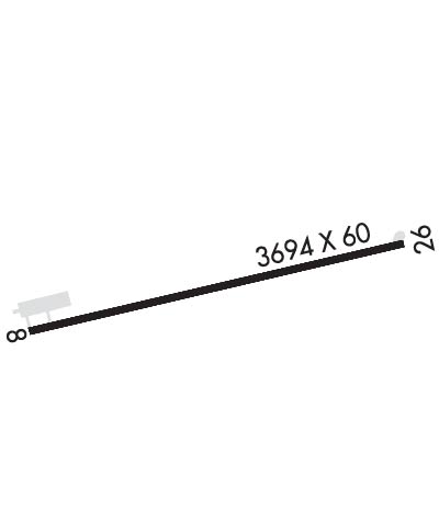
    Length: 3694 ft
    Width: 60 ft
    Surface: ASPHALT-GOOD CONDITION
    Edge lights: Low Intensity

    Treatment: NONE

     Runway: 08   Runway: 26
    Mag heading: 82°Mag heading: 262°
    Rwy Slope: .00% UpRwy Slope: .00% Down
    Approach: Approach:
    Pattern: Left TrafficPattern: Left Traffic
    Markings: BASICMarkings: BASIC
    Marking Condition: GOODMarking Condition: GOOD
    Arresting Dev: Arresting Dev:
    Lat & Long: N3405.2  W07852.2Lat. & Long.: N3405.4  W07851.5
    Elev: 99.2 ft. MSLElev: 99.3 ft. MSL
    TCH: TCH: 38 ft. AGL
    Visual Glide Path: Visual Glide Path: 3.50 degrees
    Displaced Threshold: 200 feetDisplaced Threshold: No
    Touchdown Zone: YESTouchdown Zone: YES
    Touchdown Elev.: 99.3 feetTouchdown Elev.: 99.3 feet
    Visual Glide Slope: Visual Glide Slope: 2-BOX SIMPLIFIED ABBREVIATED VISUAL APPROACH SLOPE INDICATOR ON LEFT SIDE OF RUNWAY
    RVR Equipment: RVR Equipment:
    RVV Equipment: NORVV Equipment: NO
    Approach Lights: Approach Lights:
    REIL: NOREIL: NO
    Centerline Lights: NOCenterline Lights: NO
    Touchdown lights: NOTouchdown lights: NO
    Runway Category: Runway with a Visual ApproachRunway Category: Runway with a Non-precision Approach
    Declared Distances: Declared Distances:
    Obstructions: ROADObstructions: TREES
    Marked: NOT Marked/LightedMarked: NOT Marked/Lighted
    Clearance slope: 1:1; RWY 08 ST-IN APPR 21:1 TO DSP THR DUE TO 17' ROADWAY BOTH SIDES OF CENTERLINE; 358' FROM DSP THR. 50FT TREES 175' R AND AIRCRAFT ACTIVITY APRON 150' L LOCATED PARALLEL TO RWY.Clearance slope: 18:1
    Obstruction height: 17 feet AGLObstruction height: 86 feet AGL
    Dist. from runway: 200 feetDist. from runway: 1759 feet
    Centerline offset: Centerline offset: 10 feet right of centerline
    Comments: RWY 08 ROADWAY AND 50FT TREES 150' TO 175' R;DIST 0 TO 200 FT FROM RWY. AIRCRAFT ACTIVITY APRON 150FT R, DIST 0 TO 125' FROM RWY.Comments:
    C:/P: