Approach Charts
| FltPlan does not have IFR approach charts available for K5D5. |
Current Weather/Notams (Metars, TAFs, Notams, NWS Forecast, PIREPS, and nearby weather)
Customs Information Send updates to Support@FltPlan.com
Customs Not Available
Database effective 04/18/2024
| Facility Name: | WOOLSEY MEML |
| City Name: | NORTHPORT |
| County: | LEELANAU |
| State abbrev: | MI |
| State Name: | MICHIGAN |
| | |
| Ownership: | PUBLICLY OWNED |
| Use: | OPEN TO THE PUBLIC |
| Owner's Name: | LEELANAU TWP |
| Address: | 119 E NAGONABA ST, PO BOX 338 |
| | NORTHPORT, MI 49670-0338 |
| Owner's Phone: | 231-386-5282 |
| | |
| Manager's Name: | THOMAS M WETHERBEE |
| Address: | PO BOX 8 |
| | NORTHPORT, MI 49670-0008 |
| Phone: | 231-883-9841 |
| | |
| FAA Region: | GREAT LAKES |
| FAA Field Office: | DET |
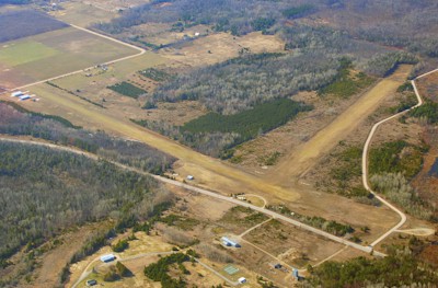
Runway Identifications
Runway Identification: 09/27Length: 3663 ft
Width: 120 ft
Surface: GRASS-GOOD CONDITION
Edge lights: Low IntensityTreatment: NONE
| | Runway: 09 | | Runway: 27 |
| Mag heading: | 92° | Mag heading: | 272° |
| Rwy Slope: | .19% Up | Rwy Slope: | -.19% Down |
| Approach: | | Approach: | |
| Pattern: | Left Traffic | Pattern: | Left Traffic |
| Markings: | | Markings: | |
| Marking Condition: | RWY & DTHR MKD WITH 3 FT YELLOW CONES. | Marking Condition: | 3 FT YELLOW CONES. |
| Arresting Dev: | | Arresting Dev: | |
| Lat & Long: | N4509.8 W08535.1 | Lat. & Long.: | N4509.8 W08534.2 |
| Elev: | 616.0 ft. MSL | Elev: | 623.0 ft. MSL |
| TCH: | | TCH: | |
| Visual Glide Path: | | Visual Glide Path: | |
| Displaced Threshold: | 266 feet | Displaced Threshold: | No |
| Touchdown Zone: | NO | Touchdown Zone: | NO |
| Touchdown Elev.: | | Touchdown Elev.: | |
| Visual Glide Slope: | | Visual Glide Slope: | |
| RVR Equipment: | | RVR Equipment: | |
| RVV Equipment: | NO | RVV Equipment: | NO |
| Approach Lights: | | Approach Lights: | |
| REIL: | NO | REIL: | NO |
| Centerline Lights: | NO | Centerline Lights: | NO |
| Touchdown lights: | NO | Touchdown lights: | NO |
| Runway Category: | Runway with a Visual Approach | Runway Category: | Runway with a Visual Approach |
| Declared Distances: | | Declared Distances: | |
| Obstructions: | ROAD | Obstructions: | TREES |
| Marked: | NOT Marked/Lighted | Marked: | NOT Marked/Lighted |
| Clearance slope: | 2:1; APCH RATIO 20:1 TO DTHR. | Clearance slope: | 22:1 |
| Obstruction height: | 14 feet AGL | Obstruction height: | 60 feet AGL |
| Dist. from runway: | 35 feet | Dist. from runway: | 1330 feet |
| Centerline offset: | | Centerline offset: | 100 feet left of centerline |
| Comments: | | Comments: | |
Runway Identification: 16/34Length: 2670 ft
Width: 150 ft
Surface: GRASS-FAIR CONDITION
Edge lights: Treatment: NONE
| | Runway: 16 | | Runway: 34 |
| Mag heading: | 164° | Mag heading: | 344° |
| Rwy Slope: | .75% Up | Rwy Slope: | -.75% Down |
| Approach: | | Approach: | |
| Pattern: | Left Traffic | Pattern: | Left Traffic |
| Markings: | | Markings: | |
| Marking Condition: | RWY & DTHR MKD WITH 3 FT YELLOW CONES. | Marking Condition: | RWY & DTHR MKD WITH 3 FT YELLOW CONES. |
| Arresting Dev: | | Arresting Dev: | |
| Lat & Long: | N4510.2 W08534.5 | Lat. & Long.: | N4509.8 W08534.3 |
| Elev: | 605.0 ft. MSL | Elev: | 625.0 ft. MSL |
| TCH: | | TCH: | |
| Visual Glide Path: | | Visual Glide Path: | |
| Displaced Threshold: | 770 feet | Displaced Threshold: | 300 feet |
| Touchdown Zone: | NO | Touchdown Zone: | NO |
| Touchdown Elev.: | | Touchdown Elev.: | |
| Visual Glide Slope: | | Visual Glide Slope: | |
| RVR Equipment: | | RVR Equipment: | |
| RVV Equipment: | NO | RVV Equipment: | NO |
| Approach Lights: | | Approach Lights: | |
| REIL: | NO | REIL: | NO |
| Centerline Lights: | NO | Centerline Lights: | NO |
| Touchdown lights: | NO | Touchdown lights: | NO |
| Runway Category: | Runway with a Visual Approach | Runway Category: | Runway with a Visual Approach |
| Declared Distances: | | Declared Distances: | |
| Obstructions: | TREES | Obstructions: | ROAD |
| Marked: | NOT Marked/Lighted | Marked: | NOT Marked/Lighted |
| Clearance slope: | APCH RATIO 20:1 TO DTHR OVR +48 FT TREE, 960 FT DIST, 125 FT R. | Clearance slope: | 5:1; CTLG OBSTN EXCEEDS A 45 DEG SLP. APCH RATIO 18:1 TO DTHR OVR 34 FT TREE, 620 FT DIST; 25:1 OVR 17 FT BLDG, 425 FT DIST, L OF CNTRLN. |
| Obstruction height: | 27 feet AGL | Obstruction height: | 10 feet AGL |
| Dist. from runway: | 0 feet | Dist. from runway: | 50 feet |
| Centerline offset: | 122 right of centerline | Centerline offset: | |
| Comments: | | Comments: | |