
| ||||||||||||||||||||||||||||||||
| ||||||||||||||||||||||||||||||||
| ||||||||||||||||||||||||||||||||
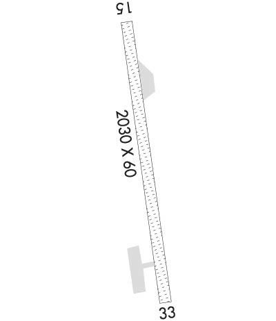
| Rwy | Rwy | |||||||
| 2030x60 | 2030' | 2030x60 | 2030' | |||||
| Runway ID | Single Wheel | Double Wheel | Double Tandem Wheel | Dual Double Wheel |
| 15/33 | N/A | N/A | N/A | N/A |
| These numbers are Advisory and are not limits. The Airport Manager should have more accurate Weight Limits | ||||
| FltPlan does not have IFR approach charts available for K5A8. |
 Airport Diagram might not be current. | |
| Facility Name: | ALEKNAGIK /NEW |
| City Name: | ALEKNAGIK |
| County: | DILLINGHAM |
| State abbrev: | AK |
| State Name: | ALASKA |
| Ownership: | PUBLICLY OWNED |
| Use: | OPEN TO THE PUBLIC |
| Owner's Name: | ALASKA DOT&PF CENTRAL REGION |
| Address: | PO BOX 196900 |
| ANCHORAGE, AK 99519-6900 | |
| Owner's Phone: | 907-269-0760 |
| Manager's Name: | JON TAYLOR |
| Address: | BOX 250 |
| DILLINGHAM, AK 99576 | |
| Phone: | 907-842-5511 |
| FAA Region: | ALASKA |
| FAA Field Office: | NONE |
| Date | Sunrise | Sunset |
|---|---|---|
| 04/25/24 Thursday | 6:49 | 22:17 |
| 04/26/24 Friday | 6:46 | 22:19 |
| 04/27/24 Saturday | 6:44 | 22:22 |
| 04/28/24 Sunday | 6:41 | 22:24 |
| 04/29/24 Monday | 6:38 | 22:26 |
| 04/30/24 Tuesday | 6:36 | 22:29 |
| 05/01/24 Wednesday | 6:33 | 22:31 |
| 05/02/24 Thursday | 6:31 | 22:33 |
| 05/03/24 Friday | 6:28 | 22:36 |
| 05/04/24 Saturday | 6:25 | 22:38 |
| 05/05/24 Sunday | 6:23 | 22:41 |
| 05/06/24 Monday | 6:20 | 22:43 |
| 05/07/24 Tuesday | 6:18 | 22:45 |
| 05/08/24 Wednesday | 6:15 | 22:48 |
| Airport Attendance Schedule | UNATTENDED |
| Airport Status | OPERATIONAL (This Status can change at any time - please check NOTAMS) |
| Airport Lighting Schedule | |
| Airport Storage Available | Tie Downs |
| Extra Services Available | NONE |
| Wind Indicator | YES - (unlit) |
| Control Tower | NO |
| CTAF Frequency | 122.900 |
| Unicom Frequency | |
| Rotating Beacon Color | |
| Segmented Circle | NO |
| Landing Fee |
| Airport Inspected | CONTRACTOR - performed by PRIVATE CONTRACT PERSONNEL |
| Inspection Date | 05/22/2021 |
| Type of Fuel Available | None |
| Airframe Repair Service | None |
| Power Plant Repair Service | None |
| Latitude | N5917.0 |
| Longitude | W15837.1 (ESTIMATED) |
| Arpt Elevation | 63ft (ESTIMATED) |
| Magnetic Variation | 20E |
| 1 miles E | of ALEKNAGIK |
| Traffic Pattern Altitude | |
| Sectional Chart | KODIAK |
| Operations (Reported) | Yearly | Avg. Daily |
|---|---|---|
| General Aviation Transient | 500 | 1 |
| General Aviation Local | 0 | 0 |
| Air Taxi | 430 | 1 |
| Commerical | 0 | 0 |
| Commuter | 0 | 0 |
| Military | 0 | 0 |
| Aircraft based on Field | |
|---|---|
| General Aviation Singles | 0 |
| General Aviation Multi | 0 |
| Jet Aircraft | 0 |
| General Aviation Helicopters | 0 |
| Military Aircraft | 0 |
| Gliders | 0 |
| Ultralights | 0 |
| FSS on field | NO |
| FSS tie-in | DILLINGHAM |
| FSS Phone | 842-5275 (Local call) |
| Nearby FSS | KENAI |
| Phone | 1-800-866-864-1737 |
| Who issues Notams | DLG |
| Notam D service at airport | YES |
| ARTCC Name | ANCHORAGE |
| Airport Certification | |
| Aircraft Rescue & Firefighting Index | None |
| Airport of Entry | No |
| Custom Landing Rights | No |
| Joint Civil/Military | No |
| Military Landing rights | YES |
| NATIONAL PLAN OF INTEGRATED AIRPORT SYSTEMS (NPIAS) |
| RWY COND NOT MONITORED; RCMD VISUAL INSPECTION PRIOR TO USE. NO SNOW REMOVAL. |
| BE ALERT: FLOAT PLANES LNDG & DEPG BTN N AND S SHORES ON THE ALEKNAGIK IN THE AREAS OF ALEKNAGIK LODGE & MOSQUITO POINT. |
| BE ALERT: RWY ELEVD ABV SRNDG TRRN; NO SAFETY AREAS AT EITHER THLD. |
| RWY SLOPES DOWN TOWARD DEP END OF RWY 15. |
| TREES ON APCH OF RWY 15, PWR LINES ON APCH OF RWY 33. |
| LOOSE ROCKS ON RWY. |
| SEGMENTED CIRCLE IS OVERGROWN AND UNUSEABLE |
| Runway: 15 | Runway: 33 | ||
| Mag heading: | 144° | Mag heading: | 324° |
| Rwy Slope: | -.49% Down | Rwy Slope: | .49% Up |
| Approach: | Approach: | ||
| Pattern: | Left Traffic | Pattern: | Left Traffic |
| Markings: | NONSTANDARD | Markings: | NONSTANDARD |
| Marking Condition: | RWY 15/33 MKD WITH ORANGE 3 FT CONES. | Marking Condition: | |
| Arresting Dev: | Arresting Dev: | ||
| Lat & Long: | N5917.1 W15837.2 | Lat. & Long.: | N5916.8 W15837.0 |
| Elev: | 61.7 ft. MSL | Elev: | 51.8 ft. MSL |
| TCH: | TCH: | ||
| Visual Glide Path: | Visual Glide Path: | ||
| Displaced Threshold: | No | Displaced Threshold: | No |
| Touchdown Zone: | NO | Touchdown Zone: | NO |
| Touchdown Elev.: | Touchdown Elev.: | ||
| Visual Glide Slope: | Visual Glide Slope: | ||
| RVR Equipment: | RVR Equipment: | ||
| RVV Equipment: | NO | RVV Equipment: | NO |
| Approach Lights: | Approach Lights: | ||
| REIL: | NO | REIL: | NO |
| Centerline Lights: | NO | Centerline Lights: | NO |
| Touchdown lights: | NO | Touchdown lights: | NO |
| Runway Category: | Runway with a Visual Approach | Runway Category: | Runway with a Visual Approach |
| Declared Distances: | Declared Distances: | ||
| Obstructions: | TREE | Obstructions: | BRUSH |
| Marked: | NOT Marked/Lighted | Marked: | NOT Marked/Lighted |
| Clearance slope: | Clearance slope: | ||
| Obstruction height: | 9 feet AGL | Obstruction height: | 6 feet AGL |
| Dist. from runway: | 0 feet | Dist. from runway: | 0 feet |
| Centerline offset: | 84 right of centerline | Centerline offset: | 50 feet right of centerline |
| Comments: | Comments: |
