Click here for more info on on SMS!

K58N

REIGLE FIELD
PALMYRA
PA
Time Zone: Eastern
Lat: N 4017.2
Long: W 07634.6
Elev: 489
Var: +10
Longest Runway: 1955
CTAF: 122.8

FBO & Flight Services info for K58N

FBOs: Update your Fuel Prices
Reigle Airport was established in 1942 by Chas and Ada Reigle, with the aspiration of providing access to the sky for aviation enthusiasts. Genuine, friendly service, Reigle's family-owned flight operation base is a place for comfort and familiar faces. Four generations later, the Reigle Airfield continues to fulfill the aviator's needs.
Ph: 717-838-5319
-
Freq: 122.8WebsiteE-Mail
Service
Jet
100LL
SAF
MoGas
Fuel Avail: Self Serve Automated Fuel Pump
Full        Last Update: 04/08/2024 07:58

Self  7.00    
Misc. Info: Address: 1805 S FORDS RD   PALMYRA, PA 17078

If you are an FBO, call 1-203-262-1700 to update your info or email: FltPlan.Advertising@garmin.com
Advertise your FBO on FltPlan.com

Runway & Approach Info for K58N
Rwy
Length
Land Dist**
Approach*
  Rwy
Length
Land Dist**
Approach*
13
1955x40  1955'          
 
  
31
  1955x40  1655'          
 
 * only ILS, LOC, LDA, and SDF approaches to a specific runway are shown
** For any Declared Landing Distance Available, please see A/FD or Approach plates
Runway Weight Capability (lbs.) Help
Runway IDSingle WheelDouble WheelDouble Tandem WheelDual Double Wheel
13/3112,500N/AN/AN/A
These numbers are Advisory and are not limits.   The Airport Manager should have more accurate Weight Limits
Approach Charts
Approaches    
Current Weather/Notams
Customs Information Send updates to Support@FltPlan.com
Customs Not Available
Database effective 04/18/2024
Airport Diagram of K58N
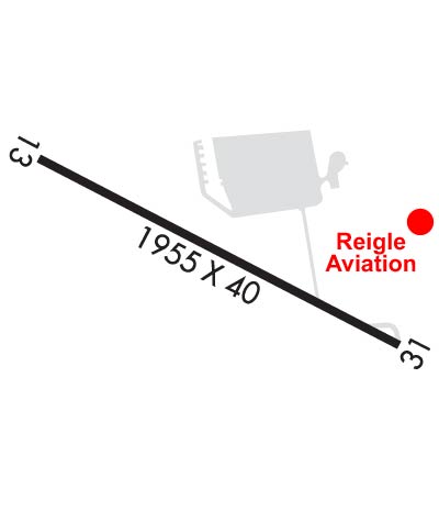
Airport Diagram might not be current.

Facility Name: REIGLE FLD
City Name: PALMYRA
County: LEBANON
State abbrev: PA
State Name: PENNSYLVANIA
   
Ownership: PRIVATELY OWNED
Use: OPEN TO THE PUBLIC
Owner's Name: DUANE REIGLE/MICHELLE WOLF
Address: 1805 S FORGE RD
 PALMYRA, PA 17078
Owner's Phone: 717-838-5519
  
Manager's Name: MICHELLE WOLF
Address: 1805 S FORGE RD
 PALMYRA, PA 17078
Phone: 717-838-5519
   
FAA Region: EASTERN
FAA Field Office: HAR


Sunrise / Sunset times for REIGLE FLD

DateSunriseSunset
04/17/24 Wednesday6:2419:48
04/18/24 Thursday6:2319:49
04/19/24 Friday6:2119:50
04/20/24 Saturday6:2019:51
04/21/24 Sunday6:1819:52
04/22/24 Monday6:1719:53
04/23/24 Tuesday6:1519:54
04/24/24 Wednesday6:1419:55
04/25/24 Thursday6:1319:56
04/26/24 Friday6:1119:57
04/27/24 Saturday6:1019:58
04/28/24 Sunday6:0919:59
04/29/24 Monday6:0720:00
04/30/24 Tuesday6:0620:01

Airport Facilities

Airport Attendance Schedule7 Days A Week 0900-1700
Airport Status OPERATIONAL (This Status can change at any time - please check NOTAMS)
Airport Lighting ScheduleACTVT LIRL RWY 13/31 - CTAF.; ACTVT ROTG BCN - CTAF.
Airport Storage AvailableTie Downs, Hanger
Extra Services AvailableFlight Instruction, Aircraft Rental
Wind IndicatorYES - (unlit)
Control TowerNO
CTAF Frequency122.800
Unicom Frequency122.800
Rotating Beacon ColorWG
Segmented CircleNO
Landing Fee

Airport Inspection Data

Airport InspectedSTATE - performed by STATE AERONAUTICAL PERSONNEL
Inspection Date07/13/2023

Airport Services

Type of Fuel AvailableGrade 100LL
Airframe Repair ServiceMAJOR
Power Plant Repair ServiceMAJOR

Geographic Data

LatitudeN4017.2
LongitudeW07634.6 (ESTIMATED)
Arpt Elevation489ft (SURVEYED)
Magnetic Variation10W
2 miles Sof PALMYRA
Traffic Pattern Altitude
Sectional ChartNEW YORK

Aircraft Data

Operations (Reported)YearlyAvg. Daily
General Aviation Transient 600016
General Aviation Local 2400066
Air Taxi 00
Commerical 00
Commuter 00
Military 00
Aircraft based on Field
General Aviation Singles 65
General Aviation Multi 0
Jet Aircraft 0
General Aviation Helicopters 0
Military Aircraft 0
Gliders 0
Ultralights 0

FAA Services

FSS on field NO
FSS tie-in WILLIAMSPORT
FSS Phone 1-800-WX-BRIEF
Who issues Notams IPT
Notam D service at airport YES
ARTCC Name NEW YORK

Federal Status

Airport Certification
Aircraft Rescue & Firefighting IndexNone
Airport of EntryNo
Custom Landing RightsNo
Joint Civil/MilitaryNo
Military Landing rightsNo

Remarks

FOR CD CTC HARRISBURG APCH AT 800-932-0712.
RWY 13/3 1 NSTD LIRL; LGTS LCTD 125 FT L AND R OF CNTRLN. RWY 13; FIRST 110 FT UNLGTD. RWY 31; FIRST 60 FT UNLGTD. 1780 FT OF RWY LGTD.
Airport Communications & Frequencies:
CTAF Frequency:
122.800
Unicom Frequency:
122.800
HARRISBURG Primary Approach Frequencies:  
118.25 001-079
124.1 211-360
126.45 080-210
269.45 001-079
273.525 211-360
281.525 080-210
HARRISBURG Primary Departure Frequencies:  
118.25 001-079
124.1 211-360
126.45 080-210
269.45 001-079
273.525 211-360
281.525 080-210
Runway Identifications
Runway Identification: 13/31
Length: 1955 ft
Width: 40 ft
Surface: ASPHALT-GOOD CONDITION
Edge lights: Non-Standard Lighting System

Treatment: NONE

 Runway: 13   Runway: 31
Mag heading: 127°Mag heading: 307°
Rwy Slope: .36% UpRwy Slope: -.36% Down
Approach: Approach:
Pattern: Left TrafficPattern: Left Traffic
Markings: BASICMarkings: BASIC
Marking Condition: GOODMarking Condition: GOOD
Arresting Dev: Arresting Dev:
Lat & Long: N4017.3  W07634.8Lat. & Long.: N4017.1  W07634.4
Elev: 482.0 ft. MSLElev: 489.0 ft. MSL
TCH: TCH:
Visual Glide Path: Visual Glide Path:
Displaced Threshold: NoDisplaced Threshold: 300 feet; DSPLCD THLD IDENTIFIED AT NIGHT BY ONE GREEN LGT EACH SIDE OF RWY.
Touchdown Zone: YESTouchdown Zone: YES
Touchdown Elev.: 489.0 feetTouchdown Elev.: 489.0 feet
Visual Glide Slope: Visual Glide Slope:
RVR Equipment: RVR Equipment:
RVV Equipment: NORVV Equipment: NO
Approach Lights: Approach Lights:
REIL: NOREIL: NO
Centerline Lights: NOCenterline Lights: NO
Touchdown lights: NOTouchdown lights: NO
Runway Category: Runway with a Visual ApproachRunway Category: Runway with a Visual Approach
Declared Distances: Declared Distances:
Obstructions: Obstructions: CROPS
Marked: Marked: NOT Marked/Lighted
Clearance slope: 20:1Clearance slope: CTLNG OBSTN GTR THAN 45 DEG SLP.
Obstruction height: Obstruction height: 13 feet AGL
Dist. from runway: Dist. from runway: 202 feet
Centerline offset: Centerline offset: 98 feet left of centerline
Comments: CROPS 132 FT FM RWY.Comments: +15 FT ROAD 25-60 FT FROM RWY.
C:1/P: