Click here for more info on on SMS!

K58M

CECIL COUNTY
ELKTON
MD
Time Zone: Eastern
Lat: N 3934.5
Long: W 07552.2
Elev: 106
Var: +12
Longest Runway: 2989
CTAF: 122.8

FBO & Flight Services info for K58M

FBOs: Update your Fuel Prices
Claremont Airport is a general aviation public use facility conveniently positioned between the metropolitan areas of Baltimore/Washington and Wilmington/Philadelphia. Claremont Airport offers a unique service to the flying community. This Northeastern Maryland destination also offers many local attractions & tourist stops including parks, waterfront restaurants, museums, boating, and golfing.
Ph: 410-398-0234 Fax: 410-398-0234 Freq: 122.8WebsiteE-Mail
Service
Jet
100LL
SAF
MoGas
Fuel Avail: Self Serve 24/7
Full        Last Update: 04/10/2024 09:08

Self  5.95    
Misc. Info: Address: 166 RAINTREE LN,   ELKTON, MD 21921

If you are an FBO, call 1-203-262-1700 to update your info or email: FltPlan.Advertising@garmin.com
Advertise your FBO on FltPlan.com

Runway & Approach Info for K58M
Rwy
Length
Land Dist**
Approach*
  Rwy
Length
Land Dist**
Approach*
13
2989x70  2701'          
 
  
31
  2989x70  2388'          
 
 * only ILS, LOC, LDA, and SDF approaches to a specific runway are shown
** For any Declared Landing Distance Available, please see A/FD or Approach plates
Runway Weight Capability (lbs.) Help
Runway IDSingle WheelDouble WheelDouble Tandem WheelDual Double Wheel
13/31N/AN/AN/AN/A
These numbers are Advisory and are not limits.   The Airport Manager should have more accurate Weight Limits
Approach Charts
Approaches    
Current Weather/Notams
Customs Information Send updates to Support@FltPlan.com
Customs Not Available
Database effective 04/18/2024
Airport Diagram of K58M
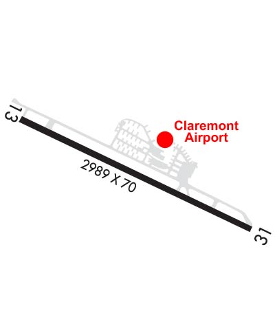
Airport Diagram might not be current.

Facility Name: CLAREMONT
City Name: ELKTON
County: CECIL
State abbrev: MD
State Name: MARYLAND
   
Ownership: PRIVATELY OWNED
Use: OPEN TO THE PUBLIC
Owner's Name: CJ FLIGHT CLA LLC; CJ FLIGHT CLA LLC DBA CLAREMONT AIRPORT.
Address: P.O. BOX 445
 ELKTON, MD 21922
Owner's Phone: (410) 398-0234
  
Manager's Name: MARY HALL
Address: P.O. BOX 445
 ELKTON, MD 21922
Phone: (410) 398-0234
   
FAA Region: EASTERN
FAA Field Office: DCA


Sunrise / Sunset times for CLAREMONT

DateSunriseSunset
04/19/24 Friday6:1919:46
04/20/24 Saturday6:1819:47
04/21/24 Sunday6:1719:48
04/22/24 Monday6:1519:49
04/23/24 Tuesday6:1419:50
04/24/24 Wednesday6:1219:51
04/25/24 Thursday6:1119:52
04/26/24 Friday6:1019:53
04/27/24 Saturday6:0819:54
04/28/24 Sunday6:0719:55
04/29/24 Monday6:0619:56
04/30/24 Tuesday6:0519:57
05/01/24 Wednesday6:0319:58
05/02/24 Thursday6:0219:59

Airport Facilities

Airport Attendance Schedule7 Days A Week 0900-1600
Airport Status OPERATIONAL (This Status can change at any time - please check NOTAMS)
Airport Lighting ScheduleACTVT REIL RWY 13 & 31; PAPI RWY 13 & 31; MIRL RWY 13/31 - 123.0.; ACTVT ROTG BCN - 123.0.
Airport Storage AvailableTie Downs
Extra Services AvailableAvionics
Wind IndicatorYES - (lighted)
Control TowerNO
CTAF Frequency122.800
Unicom Frequency122.800
Rotating Beacon ColorWG
Segmented CircleNO
Landing FeeNO

Airport Inspection Data

Airport InspectedSTATE - performed by STATE AERONAUTICAL PERSONNEL
Inspection Date03/01/2023

Airport Services

Type of Fuel AvailableGrade 100LL; -10SELF SERVE.
Airframe Repair ServiceMINOR
Power Plant Repair ServiceMINOR

Geographic Data

LatitudeN3934.5
LongitudeW07552.2 (ESTIMATED)
Arpt Elevation106ft (SURVEYED)
Magnetic Variation12W
3 miles SWof ELKTON
Traffic Pattern Altitude
Sectional ChartWASHINGTON

Aircraft Data

Operations (Reported)YearlyAvg. Daily
General Aviation Transient 10383
General Aviation Local 661018
Air Taxi 410
Commerical 00
Commuter 00
Military 500
Aircraft based on Field
General Aviation Singles 39
General Aviation Multi 4
Jet Aircraft 0
General Aviation Helicopters 0
Military Aircraft 0
Gliders 0
Ultralights 0

FAA Services

FSS on field NO
FSS tie-in LEESBURG
FSS Phone 1-800-WX-BRIEF
Who issues Notams DCA
Notam D service at airport YES
ARTCC Name NEW YORK

Federal Status

Airport Certification
Aircraft Rescue & Firefighting IndexNone
Airport of EntryNo
Custom Landing RightsNo
Joint Civil/MilitaryNo
Military Landing rightsNo

Remarks

DEER & BIRDS ON & INVOF ARPT.
REDUCED BRAKING ACTION RWY 13 DOWNHILL 1.5 DEG.
CALM/LIGHT WIND USE RWY 31.
FOR CD CTC PHILADELPHIA APCH AT (800) 354-9884.
RWY 13/3 1 RWY 13/31 NO TGL.
RWY 13/3 1 UNFILLED CRACKS, ALLIGATOR CRACKING, LATERAL & LONGL CRACKING, VEG GROWTH, OXIDATION.
Airport Communications & Frequencies:
CTAF Frequency:
122.800
Unicom Frequency:
122.800
Remarks
  • APCH/DEP SVC PRVDD BY PHILADELPHIA (PHL) APCH CTL ON 118.35/323.1
  • PHILADELPHIA Primary Approach Frequencies:  
    118.35
    323.1
    PHILADELPHIA Primary Departure Frequencies:  
    118.35
    323.1
    Runway Identifications
    Runway Identification: 13/31
    Length: 2989 ft
    Width: 70 ft
    Surface: ASPHALT-FAIR CONDITION
    Edge lights: Medium Intensity

    Treatment: AGGREGATE FRICTION SEAL COAT

     Runway: 13   Runway: 31
    Mag heading: 128°Mag heading: 308°
    Rwy Slope: -1.48% DownRwy Slope: 1.48% Up
    Approach: Approach:
    Pattern: Left TrafficPattern: Left Traffic
    Markings: BASICMarkings: NONPRECISION INSTRUMENT
    Marking Condition: FAIR; FADED.Marking Condition: FAIR; FADED.
    Arresting Dev: Arresting Dev:
    Lat & Long: N3934.6  W07552.5Lat. & Long.: N3934.3  W07551.9
    Elev: 106.4 ft. MSLElev: 62.2 ft. MSL
    TCH: 6 ft. AGLTCH: 6 ft. AGL
    Visual Glide Path: 5.00 degreesVisual Glide Path: 4.00 degrees
    Displaced Threshold: 288 feetDisplaced Threshold: 601 feet
    Touchdown Zone: YESTouchdown Zone: YES
    Touchdown Elev.: 101.4 feetTouchdown Elev.: 106.4 feet
    Visual Glide Slope: 2-Light PAPI on RIGHT side of RunwayVisual Glide Slope: 2-Light PAPI on LEFT side of Runway
    RVR Equipment: RVR Equipment:
    RVV Equipment: NORVV Equipment: NO
    Approach Lights: Approach Lights:
    REIL: YESREIL: YES
    Centerline Lights: NOCenterline Lights: NO
    Touchdown lights: NOTouchdown lights: NO
    Runway Category: Runway with a Visual ApproachRunway Category: Runway with a Visual Approach
    Declared Distances: Declared Distances:
    Obstructions: TREESObstructions: TREES
    Marked: NOT Marked/LightedMarked: NOT Marked/Lighted
    Clearance slope: 10:1; APCH SLOPE 20:1 TO DSPLCD THR AT CNTRLN.Clearance slope: 3:1; APCH SLOPE 20:1 TO DSPLCD THR AT CNTRLN.
    Obstruction height: 74 feet AGLObstruction height: 84 feet AGL
    Dist. from runway: 1003 feetDist. from runway: 481 feet
    Centerline offset: 177 right of centerlineCenterline offset: 93 feet right of centerline
    Comments: Comments: PLINE, MKD 10 FT, 40 FT FM THR.
    C:1/P: