Approach Charts
| FltPlan does not have IFR approach charts available for K57S. |
Current Weather/Notams (Metars, TAFs, Notams, NWS Forecast, PIREPS, and nearby weather)
Customs Information Send updates to Support@FltPlan.com
Customs Not Available
Database effective 05/16/2024
Airport Diagram might not be current.
|
| Facility Name: | TROY |
| City Name: | TROY |
| County: | LINCOLN |
| State abbrev: | MT |
| State Name: | MONTANA |
| | |
| Ownership: | PUBLICLY OWNED |
| Use: | OPEN TO THE PUBLIC |
| Owner's Name: | USFS; MAINTAINED BY LINCOLN COUNTY. |
| Address: | 1437 N HIGHWAY 2 |
| | TROY, MT 59935 |
| Owner's Phone: | 406-295-4693; MGR NUMBER DISCONNECTED WINTER MONTHS. CALL OWNER AT 406-295-4693 DURING THIS PERIOD. |
| | |
| Manager's Name: | GLENN WHITFIELD |
| Address: | 117 SNOWSHOE LANE |
| | TROY, MT 59935 |
| Phone: | (406) 334-7037 |
| | |
| FAA Region: | NORTHWEST MOUNTAIN |
| FAA Field Office: | HLN |
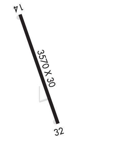
Runway Identifications
Runway Identification: 14/32Length: 3570 ft
Width: 30 ft
Surface: ASPHALT-POOR CONDITION
Edge lights: Treatment: NONE
| | Runway: 14 | | Runway: 32 |
| Mag heading: | N/A | Mag heading: | N/A |
| Approach: | | Approach: | |
| Pattern: | Left Traffic | Pattern: | Right Traffic |
| Markings: | NONSTANDARD | Markings: | NONSTANDARD |
| Marking Condition: | FAIR; RY 14 DSPLCD THLDS MKD WITH WHITE ARROWS. | Marking Condition: | FAIR; RY 32 DSPLCD THLDS MKD WITH WHITE ARROWS. |
| Arresting Dev: | | Arresting Dev: | |
| Lat & Long: | | Lat. & Long.: | |
| Elev: | N/A | Elev: | N/A |
| TCH: | | TCH: | |
| Visual Glide Path: | | Visual Glide Path: | |
| Displaced Threshold: | 825 feet | Displaced Threshold: | 780 feet |
| Touchdown Zone: | NO | Touchdown Zone: | NO |
| Touchdown Elev.: | | Touchdown Elev.: | |
| Visual Glide Slope: | | Visual Glide Slope: | |
| RVR Equipment: | | RVR Equipment: | |
| RVV Equipment: | NO | RVV Equipment: | NO |
| Approach Lights: | | Approach Lights: | |
| REIL: | NO | REIL: | NO |
| Centerline Lights: | NO | Centerline Lights: | NO |
| Touchdown lights: | NO | Touchdown lights: | NO |
| Runway Category: | Runway with a Visual Approach | Runway Category: | Runway with a Visual Approach |
| Declared Distances: | | Declared Distances: | |
| Obstructions: | TREES | Obstructions: | TREES |
| Marked: | NOT Marked/Lighted | Marked: | NOT Marked/Lighted |
| Clearance slope: | 1:1; APCH SLP 16:1 FM DTHR. | Clearance slope: | 3:1; APCH SLP 13:1 FM DTHR. |
| Obstruction height: | 40 feet AGL | Obstruction height: | 65 feet AGL |
| Dist. from runway: | 200 feet | Dist. from runway: | 445 feet |
| Centerline offset: | | Centerline offset: | |
| Comments: | RWY 14 +5 TO +80 FT TREES WI PRI SFC BGN 25 FT FM END OF RWY TO 200 FT FM END OF RWY 0B. | Comments: | +5 FT FENCE 13 FT FM END OF RWY 0B; |

