Current Weather/Notams (Metars, TAFs, Notams, NWS Forecast, PIREPS, and nearby weather)
Customs Information Send updates to Support@FltPlan.com
Customs Not Available
Database effective 05/16/2024
Airport Diagram might not be current.
|
| Facility Name: | RAY COMMUNITY |
| City Name: | RAY |
| County: | MACOMB |
| State abbrev: | MI |
| State Name: | MICHIGAN |
| | |
| Ownership: | PRIVATELY OWNED |
| Use: | OPEN TO THE PUBLIC |
| Owner's Name: | MACOMB AIRWAYS, INC |
| Address: | 59819 INDIAN TRL |
| | RAY, MI 48096-3809 |
| Owner's Phone: | 586-749-9558 |
| | |
| Manager's Name: | JOE KOZAR |
| Address: | 59819 INDIAN TRL |
| | RAY, MI 48096-3809 |
| Phone: | 586-999-8665; ADMIN BLDG 586-749-9558. |
| | |
| FAA Region: | GREAT LAKES |
| FAA Field Office: | DET |
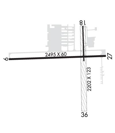
Runway Identifications
Runway Identification: 01/19Length: 2202 ft
Width: 123 ft
Surface: ASPHALT GRASS-FAIR CONDITION
Edge lights: Treatment: NONE
| | Runway: 01 | | Runway: 19 |
| Mag heading: | 5° | Mag heading: | 185° |
| Rwy Slope: | .36% Up | Rwy Slope: | -.36% Down |
| Approach: | | Approach: | |
| Pattern: | Left Traffic | Pattern: | Left Traffic |
| Markings: | | Markings: | BASIC |
| Marking Condition: | FAIR; 3 FT YELLOW CONES. | Marking Condition: | GOOD; 3 FT YELLOW CONES. |
| Arresting Dev: | | Arresting Dev: | |
| Lat & Long: | N4244.0 W08253.2 | Lat. & Long.: | N4244.4 W08253.3 |
| Elev: | 624.0 ft. MSL | Elev: | 632.0 ft. MSL |
| TCH: | | TCH: | |
| Visual Glide Path: | | Visual Glide Path: | |
| Displaced Threshold: | No | Displaced Threshold: | 140 feet |
| Touchdown Zone: | YES | Touchdown Zone: | YES |
| Touchdown Elev.: | 632.0 feet | Touchdown Elev.: | 632.0 feet |
| Visual Glide Slope: | | Visual Glide Slope: | |
| RVR Equipment: | | RVR Equipment: | |
| RVV Equipment: | NO | RVV Equipment: | NO |
| Approach Lights: | | Approach Lights: | |
| REIL: | NO | REIL: | NO |
| Centerline Lights: | NO | Centerline Lights: | NO |
| Touchdown lights: | NO | Touchdown lights: | NO |
| Runway Category: | Runway with a Visual Approach | Runway Category: | Runway with a Visual Approach |
| Declared Distances: | | Declared Distances: | |
| Obstructions: | TREE | Obstructions: | |
| Marked: | NOT Marked/Lighted | Marked: | |
| Clearance slope: | 16:1 | Clearance slope: | 20:1; APCH RATIO 20:1 TO DTHR. |
| Obstruction height: | 27 feet AGL | Obstruction height: | |
| Dist. from runway: | 439 feet | Dist. from runway: | |
| Centerline offset: | 125 right of centerline | Centerline offset: | |
| Comments: | | Comments: | |
Runway Identification: 10/28Length: 2495 ft
Width: 60 ft
Surface: ASPHALT-FAIR CONDITION
Edge lights: Medium IntensityTreatment: NONE
| | Runway: 10 | | Runway: 28 |
| Mag heading: | 94° | Mag heading: | 274° |
| Rwy Slope: | -.08% Down | Rwy Slope: | .08% Up |
| Approach: | | Approach: | |
| Pattern: | Left Traffic | Pattern: | Left Traffic |
| Markings: | BASIC | Markings: | BASIC |
| Marking Condition: | GOOD | Marking Condition: | GOOD |
| Arresting Dev: | | Arresting Dev: | |
| Lat & Long: | N4244.2 W08253.7 | Lat. & Long.: | N4244.2 W08253.1 |
| Elev: | 630.0 ft. MSL | Elev: | 628.0 ft. MSL |
| TCH: | 40 ft. AGL | TCH: | |
| Visual Glide Path: | 3.00 degrees | Visual Glide Path: | |
| Displaced Threshold: | No | Displaced Threshold: | 210 feet |
| Touchdown Zone: | YES | Touchdown Zone: | YES |
| Touchdown Elev.: | 630.0 feet | Touchdown Elev.: | 630.0 feet |
| Visual Glide Slope: | 2-Light PAPI on LEFT side of Runway | Visual Glide Slope: | 2-Light PAPI on LEFT side of Runway |
| RVR Equipment: | | RVR Equipment: | |
| RVV Equipment: | NO | RVV Equipment: | NO |
| Approach Lights: | | Approach Lights: | |
| REIL: | YES | REIL: | NO |
| Centerline Lights: | NO | Centerline Lights: | NO |
| Touchdown lights: | NO | Touchdown lights: | NO |
| Runway Category: | Runway with a Visual Approach | Runway Category: | Runway with a Visual Approach |
| Declared Distances: | | Declared Distances: | |
| Obstructions: | | Obstructions: | TREE |
| Marked: | | Marked: | NOT Marked/Lighted |
| Clearance slope: | 20:1; +8 FT SEASONAL CROPS, 226 FT DIST. | Clearance slope: | 12:1; APCH RATIO 20:1 TO DTHR. |
| Obstruction height: | | Obstruction height: | 43 feet AGL |
| Dist. from runway: | | Dist. from runway: | 757 feet |
| Centerline offset: | | Centerline offset: | 100 feet right of centerline |
| Comments: | | Comments: | ROAD, 65 FT DIST. |

