Click here for more info on on SMS!

K55Y

RUSHFORD MUNI
RUSHFORD
MN
Time Zone: Central
Lat: N 4348.9
Long: W 09149.8
Elev: 1211
Var: -01
Longest Runway: 3200
CTAF: 122.9

FBO & Flight Services info for K55Y

FBOs: Update your Fuel Prices

RUSHFORD MUNIPh: 507-864-2444
-
Freq: 122.9
Service
Jet
100LL
SAF
MoGas
Full        Last Update: 04/08/2024 08:32

Self  5.94    
 Address: 32168 AIRPORT DRIVE   PETERSEN MN 55962
If you are an FBO, call 1-203-262-1700 to update your info or email: FltPlan.Advertising@garmin.com
Advertise your FBO on FltPlan.com

Runway & Approach Info for K55Y
Rwy
Length
Land Dist**
Approach*
  Rwy
Length
Land Dist**
Approach*
16
3200x60  3200'          
 
  
34
  3200x60  3200'          
 
 * only ILS, LOC, LDA, and SDF approaches to a specific runway are shown
** For any Declared Landing Distance Available, please see A/FD or Approach plates
Runway Weight Capability (lbs.) Help
Runway IDSingle WheelDouble WheelDouble Tandem WheelDual Double Wheel
16/34N/AN/AN/AN/A
These numbers are Advisory and are not limits.   The Airport Manager should have more accurate Weight Limits
Approach Charts
Approaches    
Current Weather/Notams
Customs Information Send updates to Support@FltPlan.com
Customs Not Available
Database effective 04/18/2024
Airport Diagram of K55Y
Airport Diagram might not be current.

Facility Name: RUSHFORD MUNI/ROBERT W BUNKE FLD
City Name: RUSHFORD
County: FILLMORE
State abbrev: MN
State Name: MINNESOTA
   
Ownership: PUBLICLY OWNED
Use: OPEN TO THE PUBLIC
Owner's Name: CITY OF RUSHFORD
Address: 101 N MILL ST, PO BOX 430
 RUSHFORD, MN 55971-0430
Owner's Phone: 507-864-2444
  
Manager's Name: TONY CHLADEK; RUSHFORD@ACEGROUP.CC.
Address: 101 N MILL ST
 RUSHFORD, MN 55971-9195
Phone: 507-864-2444
   
FAA Region: GREAT LAKES
FAA Field Office: DMA


Sunrise / Sunset times for RUSHFORD MUNI/ROBERT W BUNKE FLD

DateSunriseSunset
04/18/24 Thursday6:1819:56
04/19/24 Friday6:1619:57
04/20/24 Saturday6:1519:58
04/21/24 Sunday6:1319:59
04/22/24 Monday6:1220:00
04/23/24 Tuesday6:1020:02
04/24/24 Wednesday6:0920:03
04/25/24 Thursday6:0720:04
04/26/24 Friday6:0620:05
04/27/24 Saturday6:0420:06
04/28/24 Sunday6:0320:08
04/29/24 Monday6:0120:09
04/30/24 Tuesday6:0020:10
05/01/24 Wednesday5:5820:11

Airport Facilities

Airport Attendance ScheduleUNATTENDED
Airport Status OPERATIONAL (This Status can change at any time - please check NOTAMS)
Airport Lighting ScheduleACTVT PAPI RWY 16 & 34; MIRL RWY 16/34 - CTAF.
Airport Storage AvailableTie Downs
Extra Services AvailableNONE
Wind IndicatorYES - (lighted)
Control TowerNO
CTAF Frequency122.900
Unicom Frequency
Rotating Beacon ColorWG
Segmented CircleNO
Landing FeeNO

Airport Inspection Data

Airport InspectedSTATE - performed by STATE AERONAUTICAL PERSONNEL
Inspection Date07/01/2022

Airport Services

Type of Fuel AvailableGrade 100LL; -10FUEL AVBL SELF SVC VIA CREDIT CARD.
Airframe Repair ServiceNONE
Power Plant Repair ServiceNONE

Geographic Data

LatitudeN4348.9
LongitudeW09149.8 (ESTIMATED)
Arpt Elevation1211ft (SURVEYED)
Magnetic Variation01E
3 miles Wof RUSHFORD
Traffic Pattern Altitude
Sectional ChartCHICAGO

Aircraft Data

Operations (Reported)YearlyAvg. Daily
General Aviation Transient 8002
General Aviation Local 12003
Air Taxi 00
Commerical 00
Commuter 00
Military 00
Aircraft based on Field
General Aviation Singles 4
General Aviation Multi 0
Jet Aircraft 0
General Aviation Helicopters 0
Military Aircraft 0
Gliders 0
Ultralights 0

FAA Services

FSS on field NO
FSS tie-in PRINCETON
FSS Phone 1-800-WX-BRIEF
Who issues Notams PNM
Notam D service at airport YES
ARTCC Name MINNEAPOLIS

Federal Status

Airport Certification
Aircraft Rescue & Firefighting IndexNone
Airport of EntryNo
Custom Landing RightsNo
Joint Civil/MilitaryNo
Military Landing rightsNo

Federal Agreements

NATIONAL PLAN OF INTEGRATED AIRPORT SYSTEMS (NPIAS)

Remarks

THIS AIRPORT HAS BEEN SURVEYED BY THE NATIONAL GEODETIC SURVEY.
DEER ON & INVOF ARPT.
FOR CD CTC ROCHESTER APCH AT 507-424-8111.
Airport Communications & Frequencies:
CTAF Frequency:
122.900
Remarks
  • APCH/DEP SVC PRVDD BY MINNEAPOLIS ARTCC ON FREQS 132.35/307.3 (ROCHESTER RCAG) WHEN ROCHESTER APCH CLSD.
  • ROCHESTER Primary Approach Frequencies:  
    119.8
    251.125
    ROCHESTER Primary Departure Frequencies:  
    119.8
    251.125
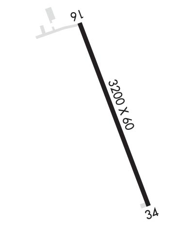
    Runway Identifications
    Runway Identification: 16/34
    Length: 3200 ft
    Width: 60 ft
    Surface: ASPHALT-GOOD CONDITION
    Edge lights: Medium Intensity

    Treatment: NONE

     Runway: 16   Runway: 34
    Mag heading: 161°Mag heading: 341°
    Rwy Slope: -.88% DownRwy Slope: .88% Up
    Approach: Approach:
    Pattern: Left TrafficPattern: Left Traffic
    Markings: NONPRECISION INSTRUMENTMarkings: NONPRECISION INSTRUMENT
    Marking Condition: GOODMarking Condition: GOOD
    Arresting Dev: Arresting Dev:
    Lat & Long: N4349.2  W09149.9Lat. & Long.: N4348.7  W09149.7
    Elev: 1211.0 ft. MSLElev: 1183.0 ft. MSL
    TCH: 40 ft. AGLTCH: 40 ft. AGL
    Visual Glide Path: 3.00 degreesVisual Glide Path: 3.00 degrees
    Displaced Threshold: NoDisplaced Threshold: No
    Touchdown Zone: NOTouchdown Zone: YES
    Touchdown Elev.: Touchdown Elev.: 1209.3 feet
    Visual Glide Slope: 2-Light PAPI on LEFT side of RunwayVisual Glide Slope: 2-Light PAPI on LEFT side of Runway
    RVR Equipment: RVR Equipment:
    RVV Equipment: NORVV Equipment: NO
    Approach Lights: Approach Lights:
    REIL: NOREIL: NO
    Centerline Lights: NOCenterline Lights: NO
    Touchdown lights: NOTouchdown lights: NO
    Runway Category: Runway with a Visual ApproachRunway Category: Runway with a Non-precision Approach
    Declared Distances: Declared Distances:
    Obstructions: Obstructions: TREES
    Marked: Marked: NOT Marked/Lighted
    Clearance slope: 20:1Clearance slope: 5:1
    Obstruction height: Obstruction height: 31 feet AGL
    Dist. from runway: Dist. from runway: 379 feet
    Centerline offset: Centerline offset: 260 feet right of centerline
    Comments: Comments:
    C:/P: