Click here for more info on on SMS!

K55K

OXFORD MUNI
OXFORD
KS
Time Zone: Central
Lat: N 3716.1
Long: W 09705.6
Elev: 1194
Var: -07
Longest Runway: 3380
CTAF: 122.9

FBO & Flight Services info for K55K

FBOs: Update your Fuel Prices

AIRPORTPh: 620-455-2223
-
Freq: 122.9
Service
Jet
100LL
SAF
MoGas
Fuel Avail: NO FUEL AVAILABLE
Full        Last Update: 04/18/2024 05:44:58

Self        
If you are an FBO, call 1-203-262-1700 to update your info or email: FltPlan.Advertising@garmin.com
Advertise your FBO on FltPlan.com

Runway & Approach Info for K55K
Rwy
Length
Land Dist**
Approach*
  Rwy
Length
Land Dist**
Approach*
17
3380x60  3380'          
 
  
35
  3380x60  3380'          
 
 * only ILS, LOC, LDA, and SDF approaches to a specific runway are shown
** For any Declared Landing Distance Available, please see A/FD or Approach plates
Runway Weight Capability (lbs.) Help
Runway IDSingle WheelDouble WheelDouble Tandem WheelDual Double Wheel
17/35N/AN/AN/AN/A
These numbers are Advisory and are not limits.   The Airport Manager should have more accurate Weight Limits
Approach Charts
FltPlan does not have IFR approach charts available for K55K.
Current Weather/Notams
Customs Information Send updates to Support@FltPlan.com
Customs Not Available
Database effective 04/18/2024
Airport Diagram of K55K
Airport Diagram might not be current.

Facility Name: OXFORD MUNI
City Name: OXFORD
County: COWLEY
State abbrev: KS
State Name: KANSAS
   
Ownership: PUBLICLY OWNED
Use: OPEN TO THE PUBLIC
Owner's Name: CITY OF OXFORD
Address: 115 S SUMNER
 OXFORD, KS 67119
Owner's Phone: 620-455-2223
  
Manager's Name: PATRICK KOPFER
Address: 115 SO. SUMNER, P.O. BOX 337
 OXFORD, KS 67119
Phone: 620-455-2223
   
FAA Region: CENTRAL
FAA Field Office: NONE


Sunrise / Sunset times for OXFORD MUNI

DateSunriseSunset
04/17/24 Wednesday6:5020:06
04/18/24 Thursday6:4920:07
04/19/24 Friday6:4720:08
04/20/24 Saturday6:4620:09
04/21/24 Sunday6:4520:10
04/22/24 Monday6:4320:11
04/23/24 Tuesday6:4220:11
04/24/24 Wednesday6:4120:12
04/25/24 Thursday6:4020:13
04/26/24 Friday6:3920:14
04/27/24 Saturday6:3720:15
04/28/24 Sunday6:3620:16
04/29/24 Monday6:3520:17
04/30/24 Tuesday6:3420:18

Airport Facilities

Airport Attendance ScheduleUNATTENDED
Airport Status OPERATIONAL (This Status can change at any time - please check NOTAMS)
Airport Lighting Schedule
Airport Storage AvailableTie Downs
Extra Services AvailableCrop Dusting
Wind IndicatorYES - (unlit)
Control TowerNO
CTAF Frequency122.900
Unicom Frequency
Rotating Beacon Color
Segmented CircleNO
Landing FeeNO

Airport Inspection Data

Airport InspectedSTATE - performed by STATE AERONAUTICAL PERSONNEL
Inspection Date05/21/2021

Airport Services

Type of Fuel AvailableNone
Airframe Repair ServiceNONE
Power Plant Repair ServiceNone

Geographic Data

LatitudeN3716.1
LongitudeW09705.6 (ESTIMATED)
Arpt Elevation1194ft (ESTIMATED)
Magnetic Variation07E
4 miles Eof OXFORD
Traffic Pattern Altitude
Sectional ChartWICHITA

Aircraft Data

Operations (Reported)YearlyAvg. Daily
General Aviation Transient 10003
General Aviation Local 15004
Air Taxi 00
Commerical 00
Commuter 00
Military 00
Aircraft based on Field
General Aviation Singles 9
General Aviation Multi 0
Jet Aircraft 0
General Aviation Helicopters 0
Military Aircraft 0
Gliders 0
Ultralights 0

FAA Services

FSS on field NO
FSS tie-in WICHITA
FSS Phone 1-800-WX-BRIEF
Who issues Notams ICT
Notam D service at airport YES
ARTCC Name KANSAS CITY

Federal Status

Airport Certification
Aircraft Rescue & Firefighting IndexNone
Airport of EntryNo
Custom Landing RightsNo
Joint Civil/MilitaryNo
Military Landing rightsYES

Federal Agreements

SURPLUS PROPERTY AGREEMENT UNDER PUBLIC LAW 289

Remarks

FOR CD CTC WICHITA APCH AT 316-350-1520.
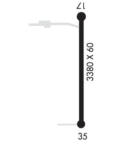
Runway Identifications
Runway Identification: 17/35
Length: 3380 ft
Width: 60 ft
Surface: ASPHALT-GOOD CONDITION
Edge lights:

Treatment: NONE

 Runway: 17   Runway: 35
Mag heading: N/AMag heading: N/A
Rwy Slope: -.06% DownRwy Slope: .06% Up
Approach: Approach:
Pattern: Left TrafficPattern: Left Traffic
Markings: BASICMarkings: BASIC
Marking Condition: FAIRMarking Condition: FAIR
Arresting Dev: Arresting Dev:
Lat & Long: N3716.4  W09705.6Lat. & Long.: N3715.9  W09705.6
Elev: 1193.6 ft. MSLElev: 1191.6 ft. MSL
TCH: TCH:
Visual Glide Path: Visual Glide Path:
Displaced Threshold: NoDisplaced Threshold: No
Touchdown Zone: NOTouchdown Zone: NO
Touchdown Elev.: Touchdown Elev.:
Visual Glide Slope: Visual Glide Slope:
RVR Equipment: RVR Equipment:
RVV Equipment: NORVV Equipment: NO
Approach Lights: Approach Lights:
REIL: NOREIL: NO
Centerline Lights: NOCenterline Lights: NO
Touchdown lights: NOTouchdown lights: NO
Runway Category: Runway with a Visual ApproachRunway Category: Runway with a Visual Approach
Declared Distances: Declared Distances:
Obstructions: Obstructions: Unknown
Marked: Marked: NOT Marked/Lighted
Clearance slope: 50:1Clearance slope: 38:1
Obstruction height: Obstruction height: 42 feet AGL
Dist. from runway: Dist. from runway: 1800 feet
Centerline offset: Centerline offset: B
Comments: +15 FT ROAD 140 FT FROM EOR.Comments:
C:/P: