Current Weather/Notams (Metars, TAFs, Notams, NWS Forecast, PIREPS, and nearby weather)
Customs Information Send updates to Support@FltPlan.com
Customs Not Available
Database effective 04/18/2024
Airport Diagram might not be current.
|
| Facility Name: | RWJ AIRPARK |
| City Name: | BAYTOWN |
| County: | CHAMBERS |
| State abbrev: | TX |
| State Name: | TEXAS |
| | |
| Ownership: | PRIVATELY OWNED |
| Use: | OPEN TO THE PUBLIC |
| Owner's Name: | RWJ PROPERTY OWNERS ASSOCIATION |
| Address: | 15814 SUNDOWNER |
| | MOUNT BELVIEU, TX 77580 |
| Owner's Phone: | (281) 573-9609 |
| | |
| Manager's Name: | DENNIS J. COX |
| Address: | 15506 SUNDOWNER |
| | BEACH CITY, TX 77523 |
| Phone: | 512-825-9771 |
| | |
| FAA Region: | SOUTHWEST |
| FAA Field Office: | TEX |
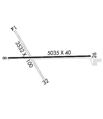
Runway Identifications
Runway Identification: 08/26Length: 5035 ft
Width: 40 ft
Surface: ASPHALT-FAIR CONDITION
Edge lights: Low IntensityTreatment: NONE
| | Runway: 08 | | Runway: 26 |
| Mag heading: | 84° | Mag heading: | 264° |
| Rwy Slope: | -.06% Down | Rwy Slope: | .06% Up |
| Approach: | | Approach: | |
| Pattern: | Left Traffic | Pattern: | Left Traffic |
| Markings: | NONSTANDARD | Markings: | NONSTANDARD |
| Marking Condition: | GOOD; RWY MKGS NSTD, NRS 35 FT TALL, THR BAR 15 INS WIDE. | Marking Condition: | GOOD; DSPLCD THR MKGS NSTD, NRS 35 FT TALL, THR BAR 15 INS WIDE. |
| Arresting Dev: | | Arresting Dev: | |
| Lat & Long: | N2945.7 W09451.3 | Lat. & Long.: | N2945.7 W09450.3 |
| Elev: | 29.8 ft. MSL | Elev: | 26.7 ft. MSL |
| TCH: | | TCH: | |
| Visual Glide Path: | | Visual Glide Path: | |
| Displaced Threshold: | No | Displaced Threshold: | 939 feet |
| Touchdown Zone: | YES | Touchdown Zone: | YES |
| Touchdown Elev.: | 29.8 feet | Touchdown Elev.: | 28.3 feet |
| Visual Glide Slope: | | Visual Glide Slope: | |
| RVR Equipment: | | RVR Equipment: | |
| RVV Equipment: | NO | RVV Equipment: | NO |
| Approach Lights: | | Approach Lights: | |
| REIL: | NO | REIL: | NO |
| Centerline Lights: | NO | Centerline Lights: | NO |
| Touchdown lights: | NO | Touchdown lights: | NO |
| Runway Category: | Runway with a Visual Approach | Runway Category: | Runway with a Non-precision Approach |
| Declared Distances: | | Declared Distances: | |
| Obstructions: | BLDG | Obstructions: | ROAD |
| Marked: | NOT Marked/Lighted | Marked: | NOT Marked/Lighted |
| Clearance slope: | 5:1 | Clearance slope: | APCH SLOPE 0:1 TO DSPLCD THR; +4 FT FENCE 92 FT R CNTRLN & +15 FT RD, 60 FT R CNTRLN AT DSPLCD THR; 18:1 OVR 85 FT WATER TWR 1600 FT 185 FT L. |
| Obstruction height: | 18 feet AGL | Obstruction height: | 10 feet AGL |
| Dist. from runway: | 300 feet | Dist. from runway: | 201 feet |
| Centerline offset: | 168 left of centerline | Centerline offset: | |
| Comments: | | Comments: | +10 FT RD 0-200 FT FM THR 60 FT R CNTRLN; +4 FT FENCE 0-200 FT FM THR 92 FT R CNTRLN. |
Runway Identification: 14/32Length: 3532 ft
Width: 100 ft
Surface: GRASS-FAIR CONDITION
Edge lights: Treatment: NONE
| | Runway: 14 | | Runway: 32 |
| Mag heading: | 143° | Mag heading: | 323° |
| Rwy Slope: | -.14% Down | Rwy Slope: | .14% Up |
| Approach: | | Approach: | |
| Pattern: | Left Traffic | Pattern: | Left Traffic |
| Markings: | | Markings: | |
| Marking Condition: | | Marking Condition: | |
| Arresting Dev: | | Arresting Dev: | |
| Lat & Long: | N2946.0 W09451.2 | Lat. & Long.: | N2945.5 W09450.8 |
| Elev: | 33.0 ft. MSL | Elev: | 28.0 ft. MSL |
| TCH: | | TCH: | |
| Visual Glide Path: | | Visual Glide Path: | |
| Displaced Threshold: | 340 feet | Displaced Threshold: | 600 feet |
| Touchdown Zone: | YES | Touchdown Zone: | YES |
| Touchdown Elev.: | 33.0 feet | Touchdown Elev.: | 31.3 feet |
| Visual Glide Slope: | | Visual Glide Slope: | |
| RVR Equipment: | | RVR Equipment: | |
| RVV Equipment: | NO | RVV Equipment: | NO |
| Approach Lights: | | Approach Lights: | |
| REIL: | NO | REIL: | NO |
| Centerline Lights: | NO | Centerline Lights: | NO |
| Touchdown lights: | NO | Touchdown lights: | NO |
| Runway Category: | Runway with a Visual Approach | Runway Category: | Runway with a Visual Approach |
| Declared Distances: | | Declared Distances: | |
| Obstructions: | ROAD; APCH SLOPE 21:1 TO DSPLCD THR OVR 31 FT TREES, 675 FT DSTC, 35 FT B. | Obstructions: | ROAD |
| Marked: | NOT Marked/Lighted | Marked: | NOT Marked/Lighted |
| Clearance slope: | APCH RATIO 15:1 TO DSPLCD THR OVER 36 FT BLDG, 565 FT DSTC, 45 FT L. | Clearance slope: | 1:1 |
| Obstruction height: | 15 feet AGL | Obstruction height: | 17 feet AGL |
| Dist. from runway: | 0 feet | Dist. from runway: | 25 feet |
| Centerline offset: | 120 left of centerline | Centerline offset: | 50B |
| Comments: | | Comments: | |

