Current Weather/Notams (Metars, TAFs, Notams, NWS Forecast, PIREPS, and nearby weather)
Customs Information Send updates to Support@FltPlan.com
Customs Not Available
Database effective 04/18/2024
Airport Diagram might not be current.
|
| Facility Name: | MADISONVILLE MUNI |
| City Name: | MADISONVILLE |
| County: | MADISON |
| State abbrev: | TX |
| State Name: | TEXAS |
| | |
| Ownership: | PUBLICLY OWNED |
| Use: | OPEN TO THE PUBLIC |
| Owner's Name: | CITY OF MADISONVILLE |
| Address: | 210 W. COTTONWOOD |
| | MADISONVILLE, TX 77864 |
| Owner's Phone: | 936-348-2748 |
| | |
| Manager's Name: | FABRICE KABONA; CITY/AMGR. |
| Address: | 210 W. COTTONWOOD |
| | MADISONVILLE, TX 77864 |
| Phone: | 936-755-0371; FABRICE KABONA@CI.MADISONVILLE.TX.US |
| | |
| FAA Region: | SOUTHWEST |
| FAA Field Office: | TEX |
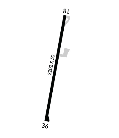
Runway Identifications
Runway Identification: 18/36Length: 3202 ft
Width: 50 ft
Surface: ASPHALT
Edge lights: Medium IntensityTreatment: NONE
| | Runway: 18 | | Runway: 36 |
| Mag heading: | 183° | Mag heading: | 3° |
| Rwy Slope: | -.83% Down | Rwy Slope: | .83% Up |
| Approach: | | Approach: | |
| Pattern: | Left Traffic | Pattern: | Left Traffic |
| Markings: | NONPRECISION INSTRUMENT | Markings: | NONPRECISION INSTRUMENT |
| Marking Condition: | GOOD | Marking Condition: | GOOD |
| Arresting Dev: | | Arresting Dev: | |
| Lat & Long: | N3055.0 W09557.1 | Lat. & Long.: | N3054.5 W09557.2 |
| Elev: | 286.7 ft. MSL | Elev: | 260.2 ft. MSL |
| TCH: | | TCH: | |
| Visual Glide Path: | | Visual Glide Path: | |
| Displaced Threshold: | No | Displaced Threshold: | No |
| Touchdown Zone: | YES | Touchdown Zone: | YES |
| Touchdown Elev.: | 286.7 feet | Touchdown Elev.: | 283.1 feet |
| Visual Glide Slope: | | Visual Glide Slope: | |
| RVR Equipment: | | RVR Equipment: | |
| RVV Equipment: | NO | RVV Equipment: | NO |
| Approach Lights: | | Approach Lights: | |
| REIL: | NO | REIL: | NO |
| Centerline Lights: | NO | Centerline Lights: | NO |
| Touchdown lights: | NO | Touchdown lights: | NO |
| Runway Category: | Runway with a Non-precision Approach | Runway Category: | Runway with a Non-precision Approach |
| Declared Distances: | | Declared Distances: | |
| Obstructions: | TREES | Obstructions: | TREES |
| Marked: | NOT Marked/Lighted | Marked: | NOT Marked/Lighted |
| Clearance slope: | | Clearance slope: | |
| Obstruction height: | 61 feet AGL | Obstruction height: | 50 feet AGL |
| Dist. from runway: | 201 feet | Dist. from runway: | 201 feet |
| Centerline offset: | 178 right of centerline | Centerline offset: | 225 feet right of centerline |
| Comments: | 50 FT TREES 156 FT R & 178 FT L, 0-199 FT DSTC. | Comments: | 50 FT TREES 180 FT L, 0-199 FT DSTC. |

