Approach Charts
| FltPlan does not have IFR approach charts available for K50D. |
Current Weather/Notams (Metars, TAFs, Notams, NWS Forecast, PIREPS, and nearby weather)
Customs Information Send updates to Support@FltPlan.com
Customs Not Available
Database effective 05/16/2024
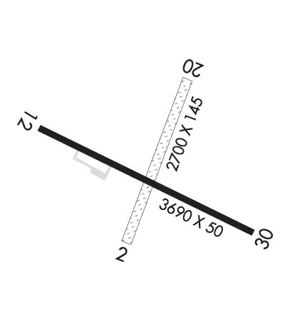
Airport Diagram might not be current.
|
| Facility Name: | IRON COUNTY |
| City Name: | CRYSTAL FALLS |
| County: | IRON |
| State abbrev: | MI |
| State Name: | MICHIGAN |
| | |
| Ownership: | PUBLICLY OWNED |
| Use: | OPEN TO THE PUBLIC |
| Owner's Name: | IRON COUNTY |
| Address: | COURTHOUSE, 2 S 6TH ST STE 7 |
| | CRYSTAL FALLS, MI 49920-1438 |
| Owner's Phone: | 906-875-3301 |
| | |
| Manager's Name: | KRIST ATANASOFF |
| Address: | 303 SELDEN RD |
| | IRON RIVER, MI 49935-1831 |
| Phone: | 906-265-6144; CELL 906-367-2563. |
| | |
| FAA Region: | GREAT LAKES |
| FAA Field Office: | DET |
Runway Identifications
Runway Identification: 02/20Length: 2700 ft
Width: 145 ft
Surface: GRASS-FAIR CONDITION
Edge lights: Treatment: NONE
| | Runway: 02 | | Runway: 20 |
| Mag heading: | 22° | Mag heading: | 202° |
| Rwy Slope: | .37% Up | Rwy Slope: | -.37% Down |
| Approach: | | Approach: | |
| Pattern: | Left Traffic | Pattern: | Left Traffic |
| Markings: | | Markings: | |
| Marking Condition: | 3 FT YELLOW CONES. | Marking Condition: | 3 FT YELLOW CONES. |
| Arresting Dev: | | Arresting Dev: | |
| Lat & Long: | N4600.4 W08816.5 | Lat. & Long.: | N4600.8 W08816.3 |
| Elev: | 1330.0 ft. MSL | Elev: | 1340.0 ft. MSL |
| TCH: | | TCH: | |
| Visual Glide Path: | | Visual Glide Path: | |
| Displaced Threshold: | No | Displaced Threshold: | No |
| Touchdown Zone: | NO | Touchdown Zone: | NO |
| Touchdown Elev.: | | Touchdown Elev.: | |
| Visual Glide Slope: | | Visual Glide Slope: | |
| RVR Equipment: | | RVR Equipment: | |
| RVV Equipment: | NO | RVV Equipment: | NO |
| Approach Lights: | | Approach Lights: | |
| REIL: | NO | REIL: | NO |
| Centerline Lights: | NO | Centerline Lights: | NO |
| Touchdown lights: | NO | Touchdown lights: | NO |
| Runway Category: | Runway with a Visual Approach | Runway Category: | Runway with a Visual Approach |
| Declared Distances: | | Declared Distances: | |
| Obstructions: | TREES | Obstructions: | TREE |
| Marked: | NOT Marked/Lighted | Marked: | NOT Marked/Lighted |
| Clearance slope: | 1:1 | Clearance slope: | 5:1 |
| Obstruction height: | 30 feet AGL | Obstruction height: | 45 feet AGL |
| Dist. from runway: | 40 feet | Dist. from runway: | 235 feet |
| Centerline offset: | 129 left of centerline | Centerline offset: | 140 feet right of centerline |
| Comments: | | Comments: | |
Runway Identification: 12/30Length: 3690 ft
Width: 50 ft
Surface: ASPHALT-POOR CONDITION
Edge lights: Non-Standard Lighting SystemTreatment: NONE
| | Runway: 12 | | Runway: 30 |
| Mag heading: | 118° | Mag heading: | 298° |
| Rwy Slope: | -.05% Down | Rwy Slope: | .05% Up |
| Approach: | | Approach: | |
| Pattern: | Left Traffic | Pattern: | Left Traffic |
| Markings: | NUMBERS ONLY | Markings: | NUMBERS ONLY |
| Marking Condition: | FAIR | Marking Condition: | FAIR |
| Arresting Dev: | | Arresting Dev: | |
| Lat & Long: | N4600.7 W08816.9 | Lat. & Long.: | N4600.4 W08816.1 |
| Elev: | 1336.0 ft. MSL | Elev: | 1334.0 ft. MSL |
| TCH: | | TCH: | |
| Visual Glide Path: | | Visual Glide Path: | |
| Displaced Threshold: | No | Displaced Threshold: | No |
| Touchdown Zone: | NO | Touchdown Zone: | NO |
| Touchdown Elev.: | | Touchdown Elev.: | |
| Visual Glide Slope: | | Visual Glide Slope: | |
| RVR Equipment: | | RVR Equipment: | |
| RVV Equipment: | NO | RVV Equipment: | NO |
| Approach Lights: | | Approach Lights: | |
| REIL: | NO | REIL: | NO |
| Centerline Lights: | NO | Centerline Lights: | NO |
| Touchdown lights: | NO | Touchdown lights: | NO |
| Runway Category: | Runway with a Visual Approach | Runway Category: | Runway with a Visual Approach |
| Declared Distances: | | Declared Distances: | |
| Obstructions: | TREES | Obstructions: | TREES |
| Marked: | NOT Marked/Lighted | Marked: | NOT Marked/Lighted |
| Clearance slope: | 9:1 | Clearance slope: | 6:1 |
| Obstruction height: | 60 feet AGL | Obstruction height: | 22 feet AGL |
| Dist. from runway: | 788 feet | Dist. from runway: | 350 feet |
| Centerline offset: | 145 left of centerline | Centerline offset: | 130 feet left of centerline |
| Comments: | | Comments: | |

